

Profile
Blog
Photos
Videos

- Blog
-
Location Date Europe 
1581120000 North America 1425081600 Oceania 1424995200 Asia 1421798400 -
-
Location Date Great Haywood 1538953200 Liverpool 1538866800 Tamfourhill 1537138800 Glasgow City 1537052400 Inveraray 1536793200 Machrihanish 1536706800 Southend 1536620400 Campbeltown 1536534000 Brodick 1536447600 Whiting Bay 1536361200 Machrie 1536274800 Strathaven 1536188400 Oxford 1536102000 Birmingham 1534374000 Chichester 1533942000 Portsmouth 1533337200 Carmarthenshire 1527980400 Aberteifi 1527548400 London 1521849600 Cheltenham 1517875200 Caerphilly 1517097600 Greenwich 1511049600 Guildford 1509753600 Bristol 1509321600 Aberdeenshire 1505516400 Crathes 1505430000 Dufftown 1505343600 Helmsdale 1505257200 Backaskaill 1505170800 Pierowall 1505084400 Kirbuster 1504998000 Orkney
1504911600 Deerness 1504825200 Kirkwall 1504479600 Birsay 1504393200 Highland 1504220400 Achany 1504134000 Dingwall 1504047600 Thornhill 1503961200 Wanlockhead 1503874800 Llandeilo 1503615600 Bletchley 1501801200 Warwick 1500764400 Kent 1500159600 Wimbledon 1499900400 Edgbaston 1498345200 Kensington 1498172400 Greater London 1496444400 Tewkesbury 1496271600 Tongwynlais 1485561600 Alton 1476918000 Pevensey 1476572400 Bodiam 1476486000 Cardiff 1475535600 Stirling 1475276400 Dunkeld 1475190000 Drumnadrochit 1475103600 Golspie 1475017200 John O' Groats 1474930800 Durness 1474844400 Talladale 1474758000 Lealt 1474671600 Tokavaig 1474585200 Glenfinnan 1474498800 Tobermory 1474412400 Argyll And Bute 1474326000 Fionnphort 1474239600 Glasgow 1474153200 Govan 1474066800 Larkhall 1473894000 Great Witley 1472425200 Nottingham 1466809200 Bolsover 1464908400 Warkworth 1464822000 Corbridge 1464735600 Northumberland 1464649200 Rothbury 1464562800 Alwinton 1464476400 Alnwick 1464390000 Richmond 1462662000 Croydon 1462575600 Caernarfon 1462143600 Conwy 1462057200 Harlech 1461970800 Manchester 1460156400 St Katharine's & Wapping 1455321600 Wood Green 1455235200 Woking 1454716800 Bishops Cleeve 1454198400 Wolverhampton 1448323200 Kingston Upon Thames 1445554800 Ayr 1442358000 Stranraer 1442271600 Dumfries 1442185200 Penrith 1442098800 Tintagel 1437260400 Wiltshire 1435359600 Tregaron 1433631600 Chedworth 1432335600 Brewood 1429916400 -
Location Date Sat, 09 September 2017 1504987708 Thu, 07 September 2017 1504813898 Wed, 06 September 2017 1504731161 Tue, 05 September 2017 1504640633 Sat, 02 September 2017
1504388847

Today I finally got to Orkney, and the sun shone all day - I had to break out the suncream!
Yesterday's excursions on Cape Wrath must've taken it out on me as I slept for a full 8 hours! Therefore it was, by my standards, a lazy start to the day. When checking out after another lovely breakfast (the sausage in particular was special) I asked about accessing the lovely beach I could see from my room, but it turns out that because it's the other side of the river it involves a drive followed by a 1 mile walk. This would've made getting to the ferry a bit tight, so instead he showed me where I could get another great view, and suggested I visit Farr Bay, just outside Bettyhill. So I followed his advice - and he was right!
I then made for Dunnet Head, via a brief petrol stop in Thurso. Dunnet Head is the northern most point of the British mainland and a place I visited last year. However, I decided to go again so that I could get a preview of Orkney as the island of Hoy is visible - and it was a lot less windy than last year!
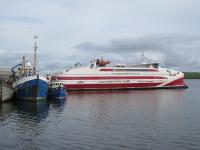
Next I revisited The Castle of Mey, but only for the tearoom. Here I tucked into a lovely Cheese and Ham Toastie and Diet Coke. Then I drove to Gills Bay Ferry Terminal, where I arrived 20 minutes before check in closed.
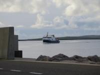
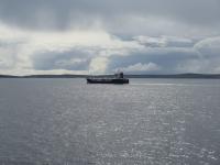
The ferry is a catamaran, so not roll-on-roll-off. This means that cars were loaded in a horseshoe arrangement around the outside of the vehicle deck, and then the rest in the middle. As soon as we left the dock, a chorus of car alarms started as many drivers hadn't disabled their alarms. The Minx stayed quiet as I hadn't locked her doors.
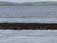
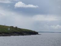
The crossing was calm and offered some great views as we passed the islands of Stroma and South Ronaldsay. After an hour we arrived at St. Margaret's Hope, in the north of South Ronaldsay.
I immediately went to the south of the island, while virtually everyone else went in the opposite direction, to visit two neolithic tombs.
The first was The Tomb of The Otters, aka Banks' Tomb. This was only discovered 10 years ago when a bistro and accompanying car park was being built. No-one realised exactly what it was that was getting in the way, so they left it and built the car park around it. It was only three years later when someone stuck a camera into the mound and saw a skull that they found it was a 5,000 year old tomb. After the fascinating introduction, I was shown the tomb. To get through the tiny entrance I had to get on my hands and knees. The tomb is unique in that it hasn't been fully excavated yet but I'd open to the public - so the one excavated chamber can be seen and the others are still full of earth. The tomb got it's name because there is plenty of evidence that otters lived among the bodies - otter skeletons and droppings and possibly buried there too
The second site was just a mile away and known as The Tomb of The Eagles. This is another 5,000 year old tomb, but the site also includes a much more recent Bronze Age site - only 3,000 years old. After an interesting introductory talk, the tomb was reached by a circular walk that was just over a mile long. The entrance to the tomb is, again, tiny. However, a trolley is provided to aid ingress and egress. Once inside, I could stand up straight and see the fully excavated chambers which followed the same layout as the Tomb of the Otters. The concrete roof has sky lights to light up the interior - sadly the original roof was destroyed well before the tomb was discovered. It got its name from the number of White Tailed Eagle bones discovered. Some human bodies were buried with more eagle bones than others, so they were probably some sort of status symbol.
I then drove back up the island a short distance to Olav's Wood. This is a beautiful off-the-beaten-track haven for wildlife that follows the course of a burn. The start of the walk passes through the youngest part of the wood, full of saplings. There are several paths to follow, but they all lead to Helen's Wood - the oldest and densest part of the wood. It's named after Helen Manson who undertook the earliest planting. Consisting of mature spruce trees, it is like entering Into The Woods of fairytales - both eerie and beautiful.
It was now time to head to Mainland Orkney. Fortunately, although I had to cross several islands, another ferry trip was not necessary - thanks to the Churchill Barriers. Nestling in the middle of this group of islands is Scapa Flow - an important naval base. However, in the second World War, it was open to U-Boat attacks due to the number of entrances available between the islands - and the Royal Oak was torpedoed and sunk here. Therefore, to make it easier to defend, Churchill ordered the construction of barriers between the islands of the eastern approaches. These are now vital road links and enabled me to drive from South Ronaldsay via Burray, Glimps Holm and Lamb Holm to reach Mainland, crossing four barriers. Alongside a couple of the barriers blockships, previous attempts to block the entrances, can still be seen.
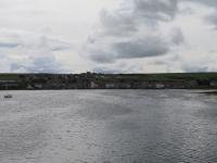
I made for one of the two main towns, Kirkwall, to find somewhere to eat, and stumbled across a chippy! So I had Haggis and Chips and Cheese, but no gravy! However, I have at last found a chippy that sells Battered Mars Bar, so had to try that. I parked next to the harbour to eat my delicious meal - and the Mars was lovely.
Then I checked in to my home for the next 9 nights. Fortunately, first impressions are that it's lovely!
Today we drove 106 miles.
- comments