

Profile
Blog
Photos
Videos
Van Trip 2007

- Blog
- Oceania
-
Location Date New South Wales 1346454000 Queensland 1346367600 Victoria 1180825200 Northern Territory 
1180479600 South Australia 1179097200 -
Location Date Tennant Creek 1180479600 Barrow Creek 1180393200 Alice Springs 1179702000 Kings Canyon 1179529200 Yulara
1179183600
Marla to Ayres Rock
Day 25
Kilometres travelled today...... 499
We left Marla at 8:30am travelling on the Stuart Highway. After crossing the border we arrived at the town of Kulgera, where we enjoyed morning coffee and sandwiches for morning tea. Kulgera is 21 kilometres north of the border with South Australia, and 275 kilometres south of Alice Springs. It is the first town you arrive at after crossing the border and sits on the junction of the Stuart Highway and the road to Aputula.
It is the southernmost permanent settlement in the Northern Territory.
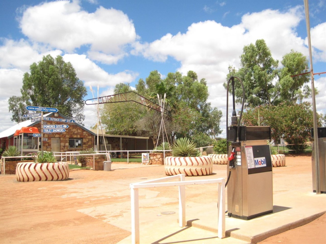
After leaving Kulgera we proceeded to Curtin Springs where we again enjoyed a coffee and cakes.
Curtin Springs is a 416,400 hectare working cattle station and roadhouse located on the Lasseter Highway, 85 kilometres east of Ayres Rock
The land was originally known as Mt Conner Station in the 1930s when it was first taken up by Paddy DeConnley. Abraham Andrews leased Mt Conner Station, together with vacant crown land, which became known as Curtin Spring Station around 1940. Curtin Springs was built in 1943 and is now owned and operated by the Severin family who took over the pastoral lease in 1956
The Severin family now offer accommodation and other services to tourists. There is also a campground with free camping without electricity and sites with electricity. There are bathrooms with showers. The station has a collection of birds and emus that are walking around the premises. One of the Emus took a liking to the cat on our caravan spare wheel cover, and spent some time stalking it.
We had originally decided to stay here overnight, but because we were only 85 kilometres from the Rock, we decided to push on.
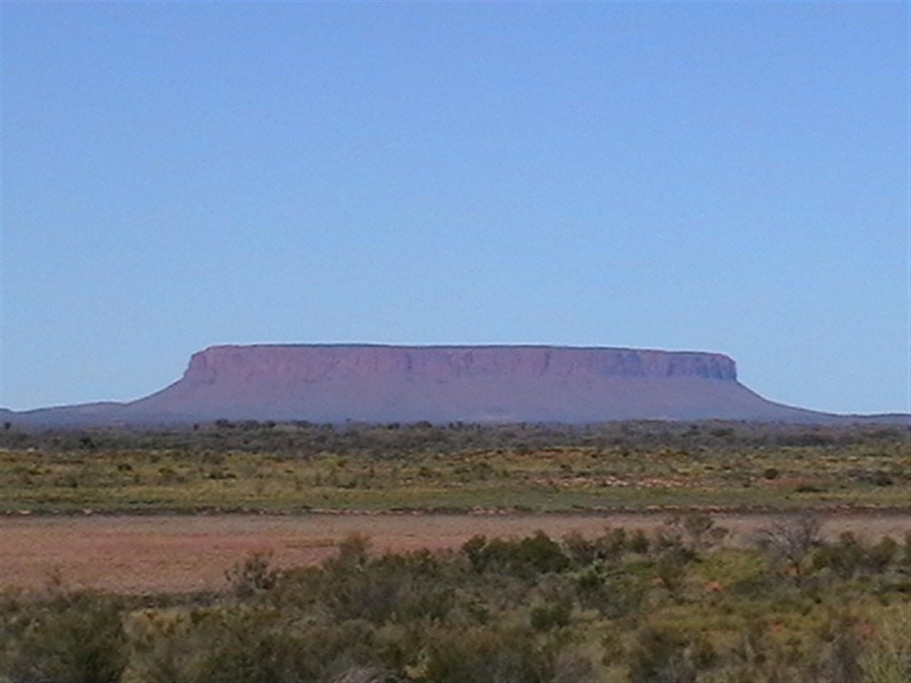
After leaving Curtin Springs we headed along the Lassiter Highway on our way to Yulara. Mid way along the highway we could see in the distance a flat mountain which we mistakenly believed to be Ayres Rock. It turned out to be Mount Connor, which looks similar to the Rock.
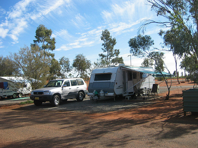
We arrived at the Yulara Resort at 3:00pm and settled in the red dust on site 58. The weather was nice and warm with a temperature of about 26 degrees.
After setting up the van it was time for happy hour, followed by sausages for dinner, cooked on the George Foreman. BLOODY FLIES !!!!
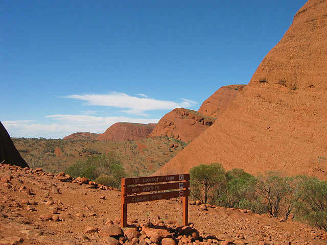
We stayed at Yulara for 4 days. visiting all of the local attractions, including. the Olgas,
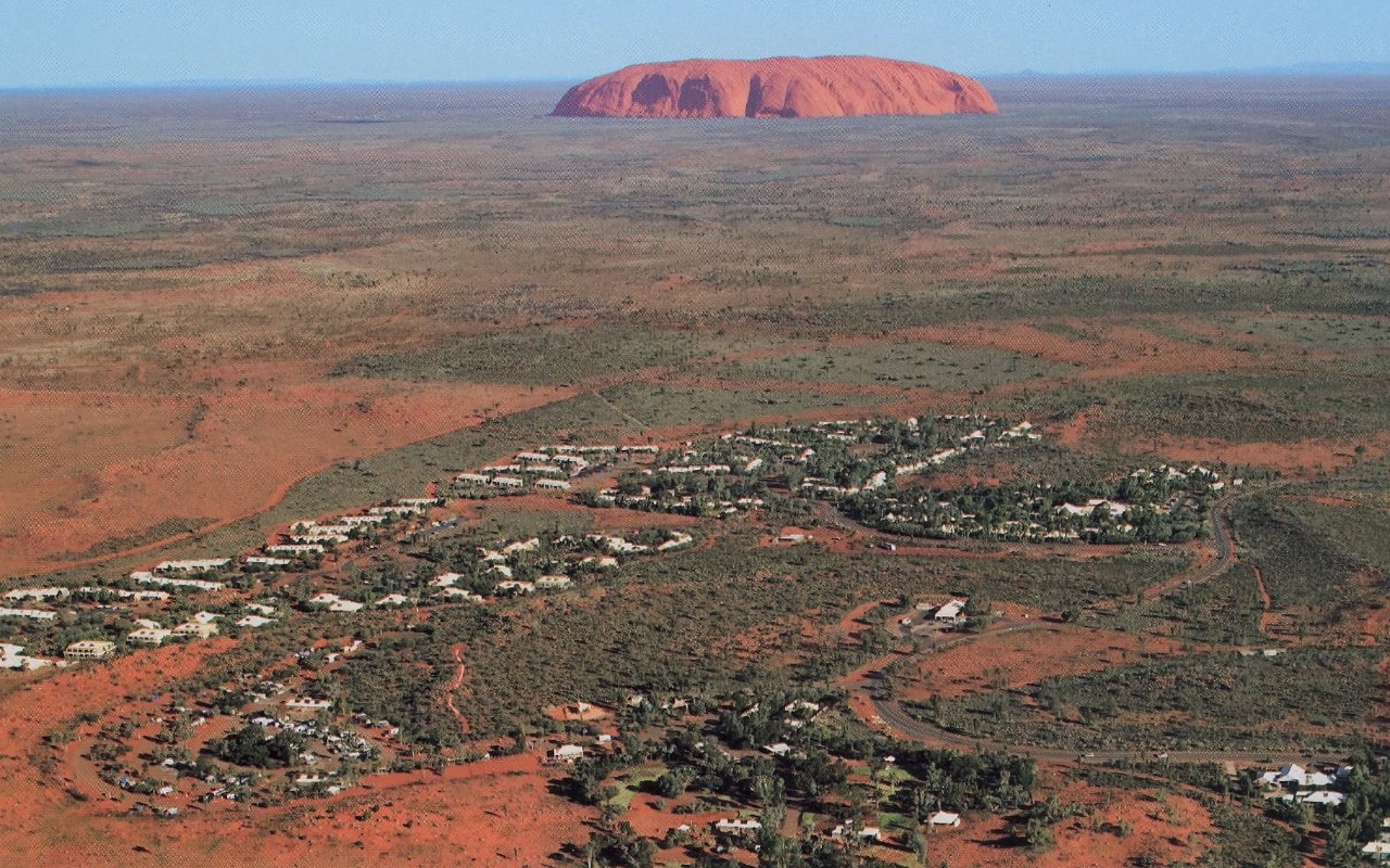
Yulara is an isolated town in the Southern Region of the Northern Territory. More than three-quarters of the residents are from either overseas or another Australian state. The name is derived from local Aboriginal words for howling and dingos. It is 18 km from Ayers Rock and 55 km from the Olgas (Kata Tjuta).
The nearby Connellan Airport makes it possible to reach the area in a few hours from Perth, Sydney, Melbourne, or Cairns , compared to five hours by car from Alice Springs, the nearest major town, 428 kilometres northeast.
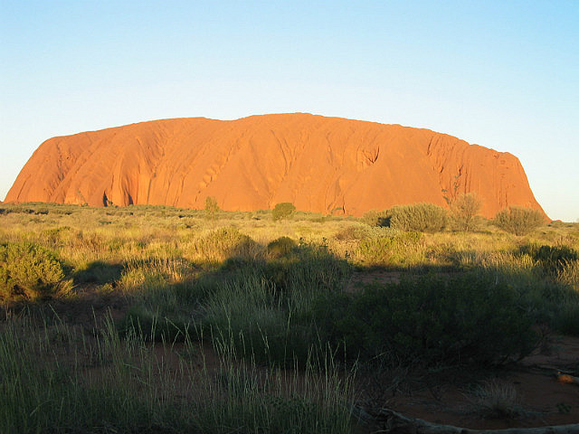
Uluru is one of Australia's most recognisable natural landmarks. The sandstone formation stands 348m high, rising 863m above sea level, with most of its bulk lying underground, and has a total circumference of 9.4 km Both Uluru and the nearby Olgas formation have great cultural significance for the Aṉangu people, the traditional inhabitants of the area, who lead walking tours to inform visitors about the local flora and fauna, & bush foods,
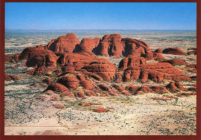
The Olgas (Kata Tjuta), sometimes known as Mount Olga are a group of large domed rock formations located about 55 kilometres from Yulara, The 36 domes that make up Kata Tjuta / Mount Olga cover an area of 21.68 km.2 The highest point, Mount Olga, is 1,066m above sea level, or approximately 546m above the.surrounding plain (198m higher than Uluru).
We spent many hours exploring the Rock and the Olgas. Whilst at the Olgas we did three walks, one of which was part of the 6km Valley of the Winds walk which was just breathtaking. It was understandable to see why this walk got its name as the wind tones were all varied, and it is easy to see why the Aboriginals believe that the spirits talk to them through these winds.
One of the highlites of our stay was a visit to the sunset viewing of the Rock with our friends from Thornleigh in Sydney, David & Cindy Bell, where we sipped Champagne, crackers and dip and watched the startling change in the colours of the Rock as the sun went down. The sunset makes the rock look more red.
This was to be our last night at Yulara. We enjoyed our 4 days exploring the magnificent scenery in the area, including the red dust and the flies. We both agreed that our favourite location was the Olgas.
We were sad to leave our friends David & Cindy, but we were to meet up with them again in Alice Springs.
Day 25
Kilometres travelled today...... 499
We left Marla at 8:30am travelling on the Stuart Highway. After crossing the border we arrived at the town of Kulgera, where we enjoyed morning coffee and sandwiches for morning tea. Kulgera is 21 kilometres north of the border with South Australia, and 275 kilometres south of Alice Springs. It is the first town you arrive at after crossing the border and sits on the junction of the Stuart Highway and the road to Aputula.
It is the southernmost permanent settlement in the Northern Territory.
After leaving Kulgera we proceeded to Curtin Springs where we again enjoyed a coffee and cakes.
Curtin Springs is a 416,400 hectare working cattle station and roadhouse located on the Lasseter Highway, 85 kilometres east of Ayres Rock
The land was originally known as Mt Conner Station in the 1930s when it was first taken up by Paddy DeConnley. Abraham Andrews leased Mt Conner Station, together with vacant crown land, which became known as Curtin Spring Station around 1940. Curtin Springs was built in 1943 and is now owned and operated by the Severin family who took over the pastoral lease in 1956
The Severin family now offer accommodation and other services to tourists. There is also a campground with free camping without electricity and sites with electricity. There are bathrooms with showers. The station has a collection of birds and emus that are walking around the premises. One of the Emus took a liking to the cat on our caravan spare wheel cover, and spent some time stalking it.
We had originally decided to stay here overnight, but because we were only 85 kilometres from the Rock, we decided to push on.
After leaving Curtin Springs we headed along the Lassiter Highway on our way to Yulara. Mid way along the highway we could see in the distance a flat mountain which we mistakenly believed to be Ayres Rock. It turned out to be Mount Connor, which looks similar to the Rock.
We arrived at the Yulara Resort at 3:00pm and settled in the red dust on site 58. The weather was nice and warm with a temperature of about 26 degrees.
After setting up the van it was time for happy hour, followed by sausages for dinner, cooked on the George Foreman. BLOODY FLIES !!!!
We stayed at Yulara for 4 days. visiting all of the local attractions, including. the Olgas,
Yulara is an isolated town in the Southern Region of the Northern Territory. More than three-quarters of the residents are from either overseas or another Australian state. The name is derived from local Aboriginal words for howling and dingos. It is 18 km from Ayers Rock and 55 km from the Olgas (Kata Tjuta).
The nearby Connellan Airport makes it possible to reach the area in a few hours from Perth, Sydney, Melbourne, or Cairns , compared to five hours by car from Alice Springs, the nearest major town, 428 kilometres northeast.
Uluru is one of Australia's most recognisable natural landmarks. The sandstone formation stands 348m high, rising 863m above sea level, with most of its bulk lying underground, and has a total circumference of 9.4 km Both Uluru and the nearby Olgas formation have great cultural significance for the Aṉangu people, the traditional inhabitants of the area, who lead walking tours to inform visitors about the local flora and fauna, & bush foods,
The Olgas (Kata Tjuta), sometimes known as Mount Olga are a group of large domed rock formations located about 55 kilometres from Yulara, The 36 domes that make up Kata Tjuta / Mount Olga cover an area of 21.68 km.2 The highest point, Mount Olga, is 1,066m above sea level, or approximately 546m above the.surrounding plain (198m higher than Uluru).
We spent many hours exploring the Rock and the Olgas. Whilst at the Olgas we did three walks, one of which was part of the 6km Valley of the Winds walk which was just breathtaking. It was understandable to see why this walk got its name as the wind tones were all varied, and it is easy to see why the Aboriginals believe that the spirits talk to them through these winds.
One of the highlites of our stay was a visit to the sunset viewing of the Rock with our friends from Thornleigh in Sydney, David & Cindy Bell, where we sipped Champagne, crackers and dip and watched the startling change in the colours of the Rock as the sun went down. The sunset makes the rock look more red.
This was to be our last night at Yulara. We enjoyed our 4 days exploring the magnificent scenery in the area, including the red dust and the flies. We both agreed that our favourite location was the Olgas.
We were sad to leave our friends David & Cindy, but we were to meet up with them again in Alice Springs.
- comments