

Profile
Blog
Photos
Videos
Van Trip 2007

- Blog
- Oceania
-
Location Date New South Wales 1346454000 Queensland 1346367600 Victoria 1180825200 Northern Territory 
1180479600 South Australia 1179097200 -
Location Date Tennant Creek
1180479600 Barrow Creek 1180393200 Alice Springs 1179702000 Kings Canyon 1179529200 Yulara 1179183600
Wycliffe Well to Barkly Homestead
Day 40
Kilometres travelled today........ 345
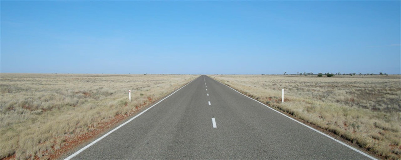
Our plans changed however. When we arrived at the Three Ways in the Northern Territory, we decided head back to the Queensland Coast via the Barkley Homestead, Camooweal, Mount Isa, Cloncurry and Charters Towers to Rollingstone Beach 50 kilometres north of Townsville
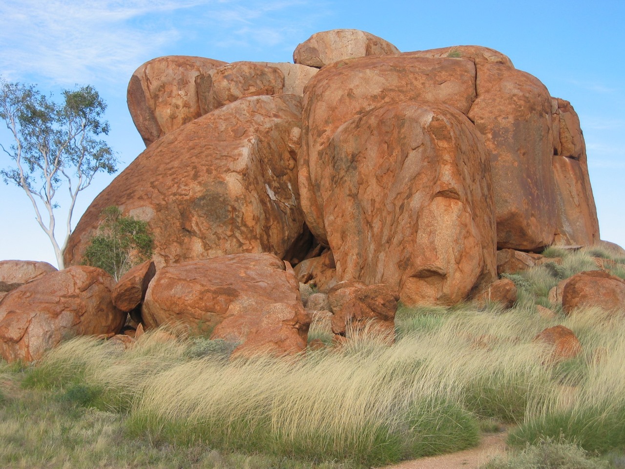
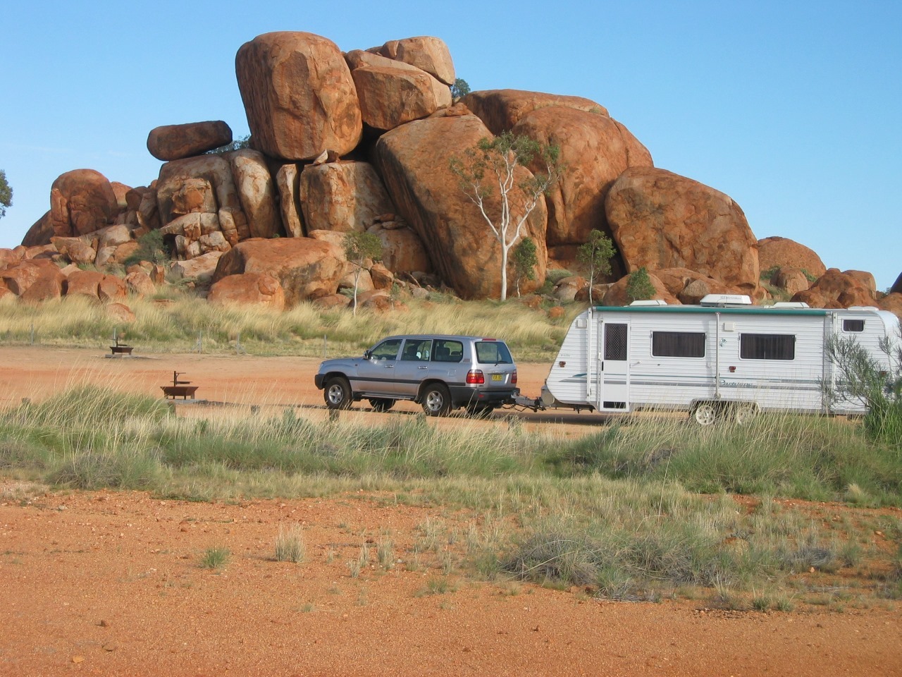
The area is located near Wauchope, approximately 114 km south of Tennant Creek, in the Northern Territory. The site is known as Karlu Karlu to the land's Aboriginal traditional owners. The 'Devils Marbles' or 'Karlu Karlu' with its gigantic, rounded granite boulders, some spectacularly poised, is a remarkable landscape. Scattered clusters of these 'marbles', including many balancing rocks, are spread across a wide, shallow valley. The Devils Marbles is a nationally and internationally recognised symbol of Australia’s outback.
The Devils Marbles are made of granite, which surfaces like a little geological island in the desert, surrounded by large amounts of sandstone. The granite was formed millions of years ago as a result of the hardening of magma within the Earth's crust. Thick layers of sandstone on top of it put a lot of pressure on this granite. After the folding of the Earth's crust, which lead to the lifting of the granite and the erosion of the sandstone, the granite came to the surface. The pressure was gone, letting the granite expand; cracks formed, and it fell apart in big, square blocks.
One of the marbles was removed from a formation in 1953 and taken to Alice Springs to form a permanent memorial to John Flynn, the founder of the Royal Flying Doctor Service in Australia. At the time, this was seen as a way of remembering his link to the outback, but in later decades it was a source of great controversy because the rock was removed from a sacred site without the direct permission of the tribal elders. In the late 1990s, a boulder swap was arranged, and the missing marble was removed from the grave, cleaned, and returned to its original place. The grave is now marked with a similar boulder donated by the local Arrernte people.[3]
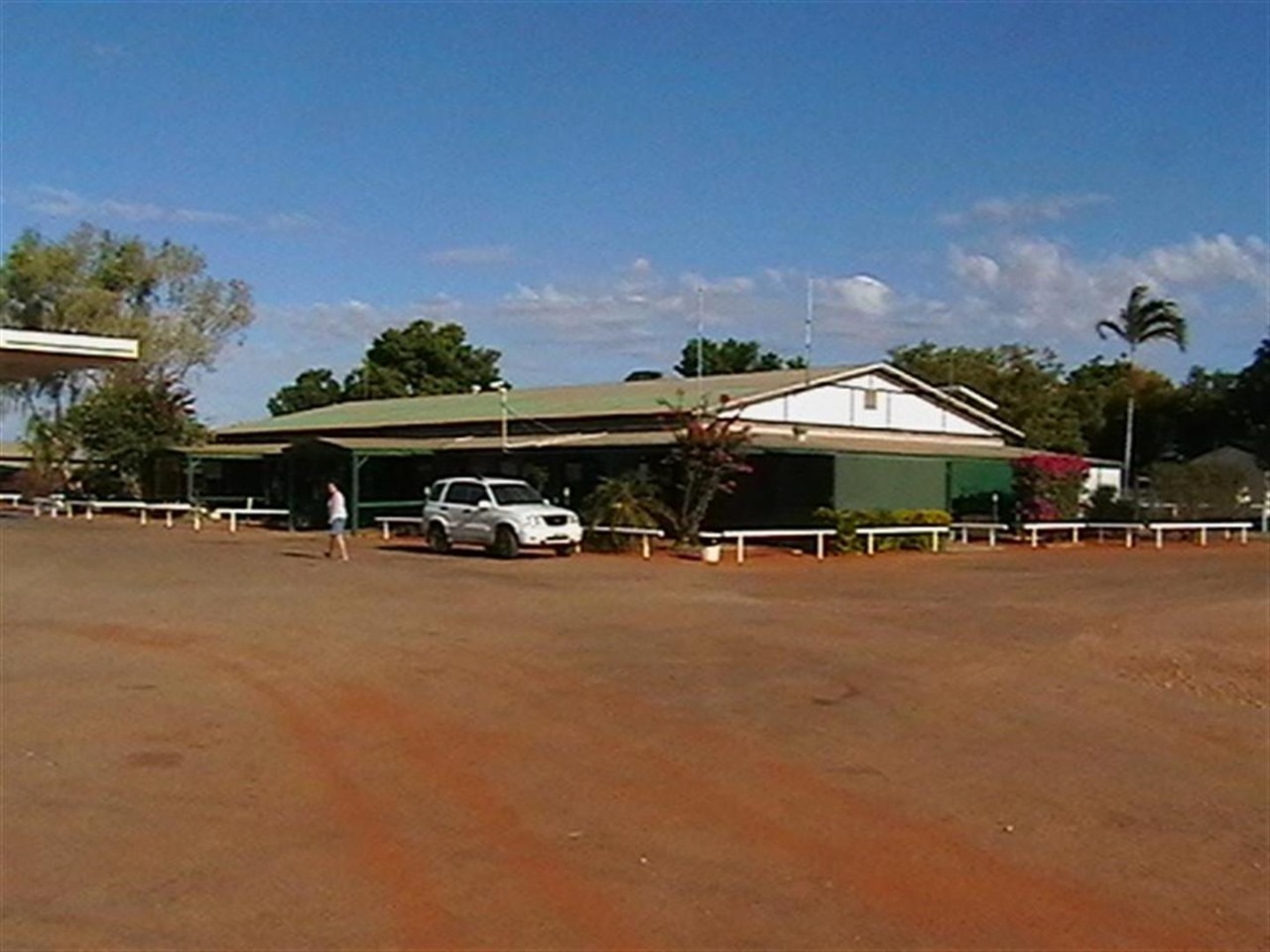
The Threeways Roadhouse and Tourist Park is situated on the corner of Barkly
& Stuart Highways and is a convenient stop for travellers heading North,
South or East.
The Roadhouse first sold fuel in the 1960's from 44 gallon
drums! In 1972 Shell developed the present site and today the Roadhouse is a
family run business with an emphasis on friendly service. Keeping with tradition
we are still a Shell fuel outlet accepting Shell fuel cards and all major credit
cards.
Our Park features spacious, shady and grassed sites for Caravans
and Campers in an outback setting. Enjoy a swim in the sparkling pool or relax
with a cold beer or wine at the bar. Cook your own meal on our free BBQ's or
dine at our restaurant and sample mouthwatering specials from our kitchen. Stay
for a couple of days and visit some of the local points of interest - Mary Ann
Dam, Devils Pebbles and so much more.
Three Ways is a roadhouse located at the junction of the Stuart
and Barkly Highways, 25 kilometres north of Tennant
Creek. This a great place to take a break and unwind during a long journey,
all while enjoying warm Northern Territory hospitality.
A local point of interest is the Flynn Memorial. Reverend John
Flynn pioneered the Royal Australian Flying Doctors Service. The memorial
originally sat at the exact meeting spot of the Barkly and Stuart Highways, but
the point has now been moved 250 metres south.
The Three Ways Roadhouse offers restaurant meals, take away
food, refreshments and fuel. It has a landscaped caravan park with barbecues, a
swimming pool, and air-conditioned motel units and cabins.
Temperatures for Three Ways
Three Ways has hot summer temperatures. The summer high
temperature for Three Ways is approximately 35 °c. The summer low temperature is
approximately 21 °c.
Three Ways has warm winter temperatures. The winter high
temperature for Three Ways is approximately 20 °c. The winter low temperature is
approximately 15 °c.
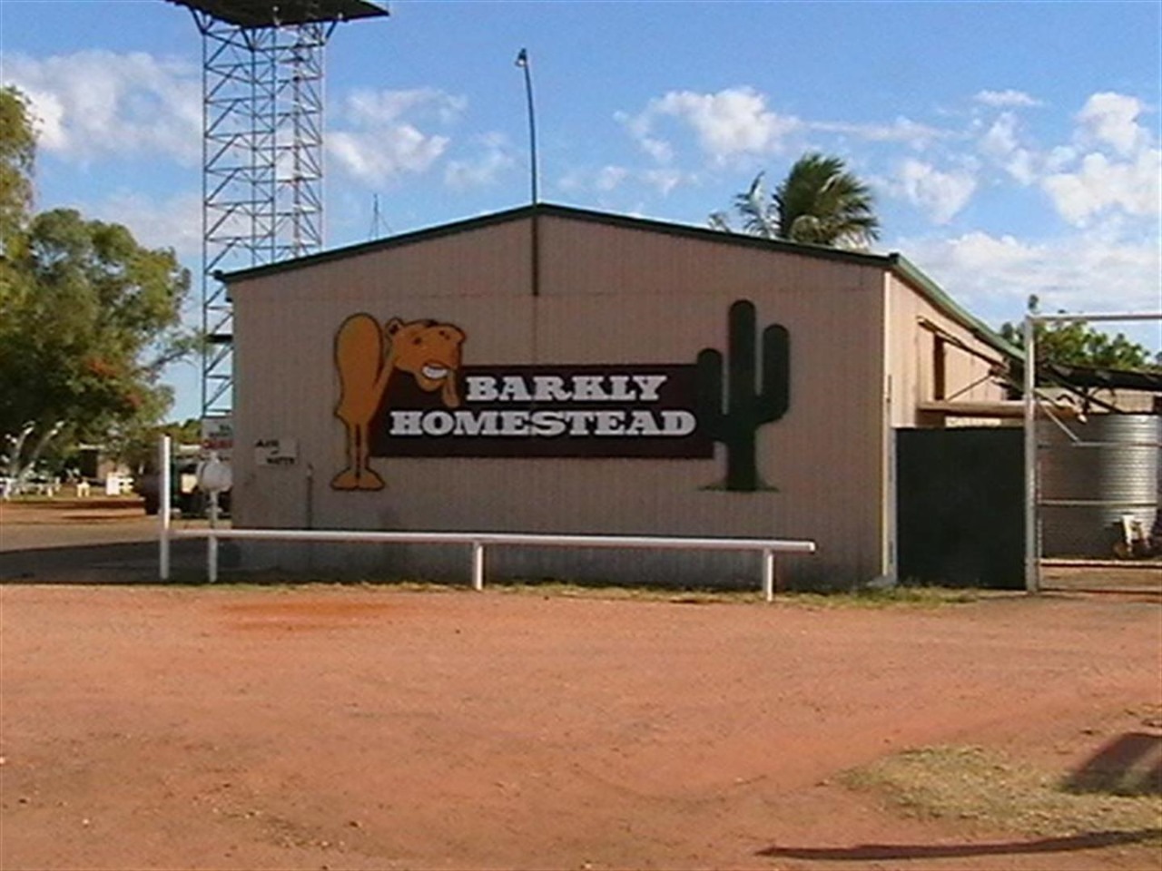
Barkly Homestead is a remote homestead situated on the Barkly Tablelands, it is located between the Queensland Border Town of Camooweal and the Northern Territory town of Tennant Creek.
The homestead provides, Fuel, Meals, Snacks, Camping, Motel, Cabin, and Powered Caravan Sites to travelers passing along the Barkly Highway[1]
The Barkly Homestead is located 210 kilometres north-east of Tennant Creek, at the junction of the Barkly Highway and the Tablelands Highway and right next to the Barkly Wayside Inn Airport. A welcome stop off point for weary travellers, the homestead offers a variety of accommodation such as modern motel units and self-contained cabins or shady grassed camping sites where you can pitch a tent or park your caravan. Relax and dine in comfort in the licensed restaurant, chill out with a cold drink... at the bar, take a dip in the refreshing pool or just unwind in the picnic area and enjoy a barbecue. With shady surrounds and great Territory hospitality, the Barkly Homestead is a key stopover point in this unique desert region and youâ??ll come away refreshed and ready to commence the next part of your travelling adventure.
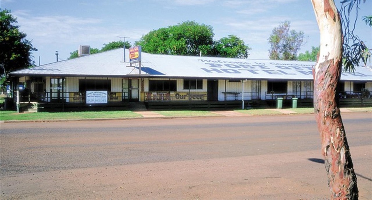
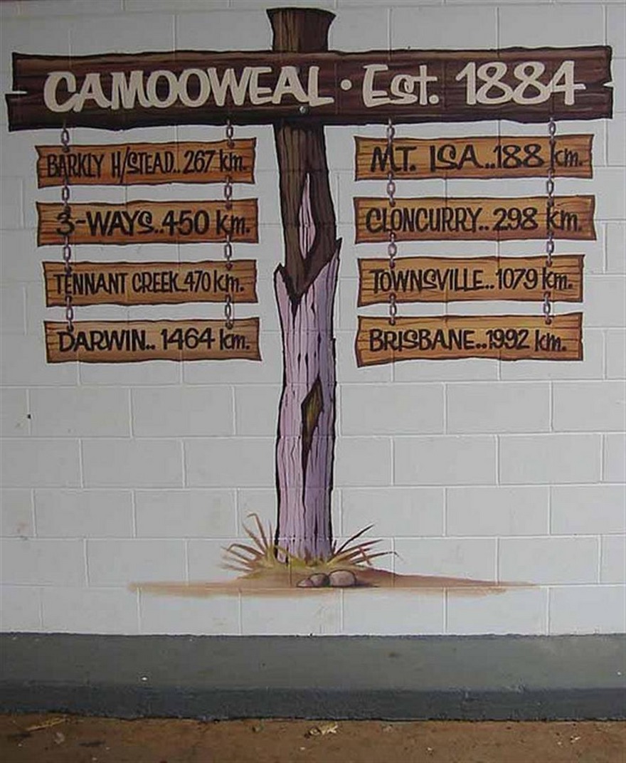
Camooweal is a small town in north-western Queensland, Australia, located 188 km north-west of the city of Mount Isa and 12 km east of the Northern Territory border. Local government is provided by the Mount Isa City Council. The town lies on the Barkly Highway, and is adjacent to the Georgina River. At the 2011 census, Camooweal had a population of 187.[1]
The area was originally inhabited by the Indjilandji Indigenous Australians.[2][3] The town is said to take its name from surveyor Mr GT Weale, who was apparently the first person to bring camels into the area,[4] although this has been questioned.[5]
William Landsborough in 1861 named the Barkly Tablelands after the Governor of Victoria, His Excellency, Sir Henry Barkly. The first settler to the area was John Sutherland, who took up the Rocklands lease in 1865. Stock losses to the local dingos and Wedge-tailed Eagles; lack of water and isolation soon forced him to abandon his lease. The Englishmen Benjamin Crosthwaite and William Tetley, who were marginally more successful, took up the lease again in 1876.
The initial town was gazetted in 1884 to be built on a 4-square-mile (10 km2) plot by Lake Francis. A year later the present site was re-gazetted and within a year a post office was built. Other milestones for the town were the addition of a police station in 1886, opening of a provisional school in 1893, drilling of the town bore in 1897 and the arrival of electricity in 1952.
The road through Camooweal to the Northern Territory was the inland defence route for World War II. This road was built by army engineers and carried over 1000 vehicles a day and there are numerous historical sites marked along the road.
The population of Camooweal is only a few hundred people. Along the main road (the Barkly Highway) there are several caravan stops or van parks which will take mobile homes and tents. There is an airstrip that is used by the Royal Flying Doctor Service to bring medical services to the town.
Australian country musician Slim Dusty (official discography) wrote a song entitled simply 'Camooweal' which features this town.
Day 40
Kilometres travelled today........ 345
Our plans changed however. When we arrived at the Three Ways in the Northern Territory, we decided head back to the Queensland Coast via the Barkley Homestead, Camooweal, Mount Isa, Cloncurry and Charters Towers to Rollingstone Beach 50 kilometres north of Townsville
The area is located near Wauchope, approximately 114 km south of Tennant Creek, in the Northern Territory. The site is known as Karlu Karlu to the land's Aboriginal traditional owners. The 'Devils Marbles' or 'Karlu Karlu' with its gigantic, rounded granite boulders, some spectacularly poised, is a remarkable landscape. Scattered clusters of these 'marbles', including many balancing rocks, are spread across a wide, shallow valley. The Devils Marbles is a nationally and internationally recognised symbol of Australia’s outback.
The Devils Marbles are made of granite, which surfaces like a little geological island in the desert, surrounded by large amounts of sandstone. The granite was formed millions of years ago as a result of the hardening of magma within the Earth's crust. Thick layers of sandstone on top of it put a lot of pressure on this granite. After the folding of the Earth's crust, which lead to the lifting of the granite and the erosion of the sandstone, the granite came to the surface. The pressure was gone, letting the granite expand; cracks formed, and it fell apart in big, square blocks.
One of the marbles was removed from a formation in 1953 and taken to Alice Springs to form a permanent memorial to John Flynn, the founder of the Royal Flying Doctor Service in Australia. At the time, this was seen as a way of remembering his link to the outback, but in later decades it was a source of great controversy because the rock was removed from a sacred site without the direct permission of the tribal elders. In the late 1990s, a boulder swap was arranged, and the missing marble was removed from the grave, cleaned, and returned to its original place. The grave is now marked with a similar boulder donated by the local Arrernte people.[3]
The Threeways Roadhouse and Tourist Park is situated on the corner of Barkly
& Stuart Highways and is a convenient stop for travellers heading North,
South or East.
The Roadhouse first sold fuel in the 1960's from 44 gallon
drums! In 1972 Shell developed the present site and today the Roadhouse is a
family run business with an emphasis on friendly service. Keeping with tradition
we are still a Shell fuel outlet accepting Shell fuel cards and all major credit
cards.
Our Park features spacious, shady and grassed sites for Caravans
and Campers in an outback setting. Enjoy a swim in the sparkling pool or relax
with a cold beer or wine at the bar. Cook your own meal on our free BBQ's or
dine at our restaurant and sample mouthwatering specials from our kitchen. Stay
for a couple of days and visit some of the local points of interest - Mary Ann
Dam, Devils Pebbles and so much more.
Three Ways is a roadhouse located at the junction of the Stuart
and Barkly Highways, 25 kilometres north of Tennant
Creek. This a great place to take a break and unwind during a long journey,
all while enjoying warm Northern Territory hospitality.
A local point of interest is the Flynn Memorial. Reverend John
Flynn pioneered the Royal Australian Flying Doctors Service. The memorial
originally sat at the exact meeting spot of the Barkly and Stuart Highways, but
the point has now been moved 250 metres south.
The Three Ways Roadhouse offers restaurant meals, take away
food, refreshments and fuel. It has a landscaped caravan park with barbecues, a
swimming pool, and air-conditioned motel units and cabins.
Temperatures for Three Ways
Three Ways has hot summer temperatures. The summer high
temperature for Three Ways is approximately 35 °c. The summer low temperature is
approximately 21 °c.
Three Ways has warm winter temperatures. The winter high
temperature for Three Ways is approximately 20 °c. The winter low temperature is
approximately 15 °c.
Barkly Homestead is a remote homestead situated on the Barkly Tablelands, it is located between the Queensland Border Town of Camooweal and the Northern Territory town of Tennant Creek.
The homestead provides, Fuel, Meals, Snacks, Camping, Motel, Cabin, and Powered Caravan Sites to travelers passing along the Barkly Highway[1]
The Barkly Homestead is located 210 kilometres north-east of Tennant Creek, at the junction of the Barkly Highway and the Tablelands Highway and right next to the Barkly Wayside Inn Airport. A welcome stop off point for weary travellers, the homestead offers a variety of accommodation such as modern motel units and self-contained cabins or shady grassed camping sites where you can pitch a tent or park your caravan. Relax and dine in comfort in the licensed restaurant, chill out with a cold drink... at the bar, take a dip in the refreshing pool or just unwind in the picnic area and enjoy a barbecue. With shady surrounds and great Territory hospitality, the Barkly Homestead is a key stopover point in this unique desert region and youâ??ll come away refreshed and ready to commence the next part of your travelling adventure.
Camooweal is a small town in north-western Queensland, Australia, located 188 km north-west of the city of Mount Isa and 12 km east of the Northern Territory border. Local government is provided by the Mount Isa City Council. The town lies on the Barkly Highway, and is adjacent to the Georgina River. At the 2011 census, Camooweal had a population of 187.[1]
The area was originally inhabited by the Indjilandji Indigenous Australians.[2][3] The town is said to take its name from surveyor Mr GT Weale, who was apparently the first person to bring camels into the area,[4] although this has been questioned.[5]
William Landsborough in 1861 named the Barkly Tablelands after the Governor of Victoria, His Excellency, Sir Henry Barkly. The first settler to the area was John Sutherland, who took up the Rocklands lease in 1865. Stock losses to the local dingos and Wedge-tailed Eagles; lack of water and isolation soon forced him to abandon his lease. The Englishmen Benjamin Crosthwaite and William Tetley, who were marginally more successful, took up the lease again in 1876.
The initial town was gazetted in 1884 to be built on a 4-square-mile (10 km2) plot by Lake Francis. A year later the present site was re-gazetted and within a year a post office was built. Other milestones for the town were the addition of a police station in 1886, opening of a provisional school in 1893, drilling of the town bore in 1897 and the arrival of electricity in 1952.
The road through Camooweal to the Northern Territory was the inland defence route for World War II. This road was built by army engineers and carried over 1000 vehicles a day and there are numerous historical sites marked along the road.
The population of Camooweal is only a few hundred people. Along the main road (the Barkly Highway) there are several caravan stops or van parks which will take mobile homes and tents. There is an airstrip that is used by the Royal Flying Doctor Service to bring medical services to the town.
Australian country musician Slim Dusty (official discography) wrote a song entitled simply 'Camooweal' which features this town.
- comments