

Profile
Blog
Photos
Videos

- Blog
-
Location Date Europe 1409526000 Asia 1403391600 Oceania 
1402786800 South America 1344639600 -
Location Date New Zealand
1402786800 Western Australia 1390608000 Queensland 1368658800 New South Wales 1364515200 Fiji 1356998400 -


The Canterbury bank holiday was fast approaching, Stevie was up in Wellington on work training. So we arranged for her return flight to go to Nelson so we could explore the Abel Tasman. I had the Friday off and would hire a car and meet her up in Nelson.
I would say I woke up early, like the start of most of our blogs, but I had a day to drive up as I didn't need to meet Stevie until 20:30.
I started the journey like most. Stopping off at McDonalds to indulge in an fat ridden quarter pounder with cheese and a box of salt that had a few fries in it.
I started the journey without GPS. Armed with nothing but a child like sense of wonder. I headed towards Arthurs Pass. My natural male compass failed when I actually arrived at Lewis pass, about 80km from Arthurs Pass.
Lewis Pass is the northernmost of the three main passes. Its located on Route 7 and traverses from north Canterbury to the west coast. Lewis Pass is named after Henry Lewis who first surveyed the passage. Stevie and I have done this route many times before as it is on the way to Hanmer Springs.
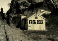
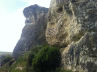
Along the drive I can cross Weka Pass a gorge where erosion has created a number of distinctive limestone formations. One well known formation is Frog Rock. I decided to pull over and walk around Frog rock because of its unusal presence in the area. When I got to the top I seemed alot higher than I was, it was a little unsettling. On my way up a small building caught my eye. So I decided to investigate. It appeared to be an old small cafe that had long been abandoned. It had no windows and Frog Rock painted in large black letters on the side.
Next to the old cafe ran a railway, which looked like it was no longer in use. However I later found out that it formed the Weka Pass Railway, one of the premier tourist railways in New Zealand. It created a nice photo so I took some artist shots before heading back to the car and headed up Route 7.
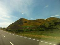
The route seemed more alive this time round. We were in mid spring and all the flowers had started to blossom turning the once snowed capped mountains into green and yellow rolling hills and valleys. From Spring Junction I reared off onto Route 65 stopping off at every opportunity to explore and take photos. I came across a herd of cows laying by the side of a the Maruia river, it took a few moments to take in how wild they looked as you usually see cow in a farmers field.
30km down Route 65, 15km from the Buller River I came across Maruia Falls which was an unexpected wide falls that formed by the Murchison Earthquake of 17 June, 1929. The resulting landslides changed the landscape and caused a drop in the bed of the Maruia River forming the falls.
I eventually reached Route 6 and headed north towards Nelson. Nelson is New Zealand's second oldest city and named after Lord Nelson. There wasnt much to do in Nelson. I looked around the streets. It had the feel of a small town on a large scale, if that makes any sense. I grabbed a Kebab and went to go back to the car when I had the realisation that I could not remember where I had parked. After some searching and back tracking I eventually found it and headed to the Airport to pick up Stevie.
I still had an 1hr 1/2 to kill so booked our water taxi's and lunch for the next day.
Stevie landed at 8.30pm, We jumped in the car and headed to the Abel Tasman which is about an hour outside Nelson down Route 60, We entered Marahau and passed Sandy bay into 'The Barn' Our Hostel on the border of the national park. We arrived late so our key was waiting for us under the long closed reception's night light. Brushing off the cobwebs I grabbed the keys and our bags and headed to the cabin Stevie had reserved. I say cabin, it was a small box with a large bed and nothing else. We passed your typical backpackers in their beads, sitting around an open fire, a solo guitar with the group singing red hot chilli pepper songs. It had been a long day for us both so we hit the sac ready for our early start.
- comments