

Profile
Blog
Photos
Videos

- Blog
- Europe
- UK
-
Location Date Windermere 1461798000 Ambleside 1461711600 Aberfoyle 1461625200 Edinburgh 1461538800 Inveraray 1461452400 Ardentinny 1461366000 Benmore 1461279600 Trossachs 1461193200 Stonehaven 1461020400 Pitcaple 1460934000 Ullapool 1460847600 Tain 1460761200 Hill Of Fearn 1460674800 Calgary 1460588400 Gometra House 1460502000 Tobermory 1460415600 Croggan 1460329200 Carsaig 
1460242800 Bunessan 1460242800 Argyll And Bute 1460156400 Glencoe 1460070000 London 1459810800
Sunday 10th April - written by Nick
Paul and Nick were the first to leave Scoor on the Sunday morning, bound for the rugged Carsaig Arches on the south coast of Mull. Karen, Matt, Nigel and Nicky were off to Ardalanish to see the weavers, not keen on the 6 hour round trip by foot that awaited us.
The drive to the small settlement at Carsaig took us along a worn piece of road, signposted with warnings of the dangers of taking heavy loads along it. Moss covered stone walls and lichen ridden trees lined our pot-holed road, but by far the greatest amusement came when we sighted one of the typical red telephone boxes, not only in an isolated location, but located directly beside a roaring waterfall! Paul tells us that the phone box made an appearance in the film "I Know Where I'm Going" which was filmed on Mull.
With us on this hike was the trusty green walking guide from the cottage bookshelf and it directed us to begin our trek from the small pier beside Carsaig House. From the pier we made our way along the coast, first scrambling over the rocky shore, then squelching across the boggy fields, across a small creek or two and through a small gate, before finding ourselves closed in by a line of steep cliffs on one side and the crashing waves on the other.
So we walked for some time, making conversation about another isolated phone box -this one in America's Mojave desert- and odds and ends of geology and history. Eventually we paused within sight of a dramatic waterfall tumbling over the cliff, had a snack and clicked some photos before heading off once more.
It was soon afterwards that we came to realise that we were not fully alone. Wandering along the grassy slopes above us was a small herd of about half a dozen goats, the nannies keeping their kids close while the billy goats bathed in the sunshine. As we continued the initial novelty wore off as we soon realised that this whole area was dominated by our bearded friends, clambering up and down the cliffs to and from the rocky shore.
We bashed on, carefully finding our way along the slightly worn path towards our goal, stopping occasionally to gaze back towards our point of departure and out across the Firth of Lorn towards Colonsay and Jura.
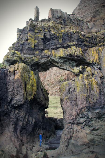
We made good time and reached the first of the two spectacular stone arches well within the outlined 3 hours, stopping on an elevated rocky outcrop to view and photograph it. The arches themselves are the result of a number of ancient lava flows which have created distinct layers of rocks of different ages and different types. The sea has then eroded through the softer of these layers over thousands of years, first forming caves before finally breaking through the black basalt rock and leaving the arch shape. Vivid green moss clung to the side of this first arch, growing in the small rivulets of water created by a nearby stream flowing down the cliff.
A quick look back through the guide book revealed the reason behind our good progress, as in our rush to see the arch we had blindly walked on by the other interesting stops along the way, including a cave used by some travelling nuns in the 16th century, and a rock shaped like a sphinx. Clearly the view of our walking boots had been much more impressive.
As we sat to eat our lunch (packed sandwiches and sausages prepared in the morning) we watched as several goats made their way along a precarious track over the top of the arch, with sheer drops onto the rocky beach on either side. They carefully made their way over the top and down the steep drop on the other side, reappearing as they wandered through the arch itself to feast upon the seaweed that had washed up.
However our bemusement at the blind courage of these animals soon turned to fear as a quick flip through our guide book led us to realise that this goat track was meant as our way over to the second arch!
The passage directly read:
Once this arch has been sufficiently admired and photographed from this point, you should retrace your steps to a small stream where a goat track leads up the gully and over the arch -a good and level path but affording no protection whatsoever against the sheer drop to the sea. One step off the path would put the walker in a totally irretrievable position, but this is the only way to get down to the beach and stand beneath the great arch.
It seemed to us from we saw that a "totally irretrievable position" was clearly a softer way of saying "dead" as the sheer drop off either side of this goat track was at least a dozen metres high and straight onto the rocky beach below.
On top of that, if the path we were confronted with could be described as "good and level" then we'd hate to see one that was in any way worse. What we saw was a narrow, muddy, stepped path dotted with goat droppings and one we were in no hurry to take.
Yet, we had come all this way, walking for close to 2 and a half hours, and we were desperate to at least glimpse the second arch, hidden away behind the first. Determined, I bravely ventured along the first section of the narrow goat track before returning with the confirmation that it was far too unsafe for us to use. Mum's words of warning to us both about not falling in, off or on anything rang in our ears. A period of indecision followed which finally ended when Paul came to realise that by making the ascent straight up the grassy, but less steep cliff face we stood a chance of making our way over to the second arch while keeping a good amount of ground between us and The Irretrievable Position. Taking this safer, although more demanding route, we finally made our way down onto the beach, legs aching and slightly wobbly from our detour.
At last we gazed upon the second, equally impressive arch, this one taller and thinner with a chimney shaped top to it. After snapping our well-earned photos and taking some time to recover, we wandered over and through the first wider arch, gaining a much closer look at the geological history layered on the inside walls.
Not long after we made our way back the way we had come, huffing and puffing as we went up and down the large slope. On our return trip we were now on the lookout for the sights we had previously missed: the Nun's Cave and the sphinx-shaped rock.
The cave was first on our way, low and slightly hidden by a small mound between it and the path -the guide book had used the sphinx rock as a way to locate it- small trickles of water created a veil to the entrance and one that was not totally unwelcomed by the two sweaty red-faced walkers. Inside the cave were many etchings into the rock, some quite recent, but many much older. A remarkable number of them sported dates from the 17 and 1800's, when the cliffs nearby were being quarried for stone used in the construction of the abbey on Iona. But the main attraction were the slightly weathered crucifixes, some quite intricate, that were supposedly etched by the nuns as they sheltered there after making their way through the cliffs via a narrow nearby pass.
A short walk away, sticking out from the cliffs and overlooking the sea was the rocky sphinx. Found it!
Another hour or more of walking led us back to our starting point at the pier where we were relieved to see the car and start the drive home.
- comments