

Profile
Blog
Photos
Videos

- Blog
-
Location Date North America 1254265200 Oceania 
1238198400 Europe 1224284400 - New Zealand
-
Location Date Christchurch 1238198400 Queenstown 1237852800 Wanaka 1237680000 Hokitika 1237507200 Nelson 1237334400 Wanganui
1237075200 Rotorua 1236902400 Whitianga 1236816000 Auckland 1236643200
When you look at a map of New Zealand, one thing that jumps out is the number of national parks and reserves. On the North Island alone, I counted at least 14. A guesstimate would be at least 10 of the island is preserved. The last two days, we've been riding through or near two of these parks - Tongariro National Park and Whanganui National Park.
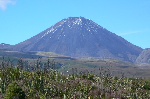
Tongariro National Park is dominated by volcanoes. There are 3 big ones all clustered together - Tongariro, Ngauruhoe and Ruapehu. Ruapehu is the highest point on the North Island and it was covered in new snow while we passed by. Ngauruhoe looks just like the volcano a school child would draw with steep sides and a craggy open top where the lava would shoot out. It was also used as the site for Mount Doom in The Lord of the Rings movies. Tongariro is broad and doesn't really look volcanic, but there is a crease in the side where a hot spring was belching steam into the air while we were near. Two people in our group took a small airplane tour over the volcano region and were amazed by the number of crater lakes high in the mountains and the number of smaller volcanoes all around the obvious ones. Three others in the group spent the day hiking instead of biking. There is a very popular 18km day-hike through the region called the Tongariro Alpine Crossing. They looked completely beat at the end of the day, but had huge smiles when asked if it was worth it.
Just a few kilometers away is Whanganui National Park. This is home to some of the last sections of virgin forest on the North Island. The longest navigable river in New Zealand runs through it and into the Tasman Sea at the town of Wanganui. The wide slow moving river makes it a great spot for a canoe trip, but we had to settle for a bike ride over a few hill tops and then a long beautiful descent following the river to the ocean.
- comments