

Profile
Blog
Photos
Videos

- Blog
- Oceania
-
Location Date Tasmania 1217890800 South Australia 
1215730800 Northern Territory 1215212400 Western Australia 1214521200 Victoria 1207263600 -
Location Date The Birdsville Track 1215730800 Nullarbor
1209250800 Eyre Peninsula 1208818800 Yorke Peninsula 1208300400 Adelaide 1208127600 Rapid Bay 1207695600
.jpg)
.jpg)

.jpg)
.jpg)
.jpg)
About 70km west of Ceduna is the small community of Penong. Penong consists of 1 shop, 1 roadhouse, 1 nice old stone pub, a primary school and about 100 windmills. Penong's thing seems to be windmills. The "welcome to Penong" sign has a picture of a windmill with some sort of statement linking Penong to Windmills. This may the only windmill led tourism boom in Australia?It'll be standing room only soon I'm sure.
About 20km south of Penong is Point Sinclair (Cactus beach). I had heard and read that Point Sinclair has "world class surf breaks". I had also heard there was a campground there but there wasn't a campground marked in any of the numerous atlases' (atlas-i?) I carry with me. I was prepared for disappointment as I had been to a few camp spots that were supposed to be good but I didn't really like (for that unknown reason again?).
I had just pulled up at the turn off to Pt Sinclair when this guy got out of a car that had pulled up coming from Pt Sinclair. He explained that he just hitched out to get some plonk for that night and would I mind giving him a lift back. I said no worries and drove him back to the Penong pub. He (Dave) made the purchase of a bottle of Port and a bag of ice (I enquired and the ice was not for the port). This was Dave's last night at the campsite after being there a week or so and he thought he might have a few drinks. Being nearly broke by this stage, Port was considered the best value for money (Dave is not Aboriginal.) He was able to give me the run down on the place plus where to have a surf.
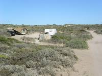
After parting company with Dave, I drove around and found myself a campsite. This is a campsite with character with the toilets being the standout feature. The campsite is in the sand dunes and in a fragile environmental area so I guess this makes septic tanks and long drops unsuitable. The toilets there are just a bucket with a seat on top. The bucket is screened by a shoulder high stone circular wall. Hence, when you take a s***, you do it alfresco.
There is a shower with same stonewall arrangement. It's perfectly discreet but your head is visible from the outside. I did enjoy watching the surfy chicks having their showers.
The other piece of character was the people that were collected there. I didn't see any grey nomads there but more your alternate types and surfies (old and young). The night I was there, at least, had a good feel.
The owner of the land (Ronny) is quite a character having been there 30 years and having done a lot of the setting up and building himself. He did get some "Coast care" funding but he did a lot of the labour himself.
The surf was relatively gentle that afternoon so I thought I would have a go. I went out on the "Castles" break. I managed to stand up a few times and enjoyed it. This was the first time I have tried surfing on a reef break so I was quite concerned about coming into contact with the bottom. So concerned that I managed to get hit on the head by my board at one stage. No damage done though and my head was ok too. A couple of women were surfing the same break and were totally showing me up (which isn't saying much). The older lady (I would be guessing late 40's by the face wrinkles?) was catching waves with regular monotony and then paddling straight back out the back again. My arms felt like they were about to drop off and I was catching a tenth of the waves she was. I didn't let this worry (much) and I still managed to have fun.
I was thinking of staying another night at Pt. Sinclair however I was feeling the urge to press on plus the weather was on the change. I had previously considered staying at Fowlers bay due to the good fishing reputably there so I decided to detour of the highway for a quick look. One thing I have found odd is that people in SA refer to this part of the coast as the West coast. I hadn't realised there was a West coast in SA?
Getting back on the Eyre highway and Nundroo is the next roadhouse to the West. This is the end of the main SA power grid. Therefore, no more power poles and lines beside the road.
There is a whale watching point at the very head of the Great Australian Bight and I wanted to drive in and have a look but the road was closed unfortunately. Disappointed about that really-it's not like I will be driving past this point everyday.
The Nullarbor Plain is marked by a large sign that is rather superfluous really. There's not a tree in sight and the sign says there a no trees here. Nullarbor is the Latin words Nullius (Nil) and Arbor (Tree) joined together i.e. nil trees. I did in fact see a few trees but only a handful of stunted, sickly looking things over a distance of several hundred kilometres of pancake flat road.
While I'm talking about names, I found out that the Eyre highway is named after Edward John Eyre. Eyre was the first European to make a land crossing of the continent from Adelaide to Albany in 1841. It took him four months and he nearly came to grief as these explorers always seem to do. I bet he would be astounded to learn that most people these days do the same trip in about 3 hours by plane.
This area of the world is known for its low rainfall but, you guessed it, when I'm here it rains. There was quite a thunderstorm with lightning hitting the ground as I was driving along. Quite spectacular.
There is nothing much in this part of the world at all with the exception of a few roadside lookouts overlooking the sea. The land is, as I said, pancake flat with the exception, that is, of the approximately 90m cliffs dropping down to the ocean. These lookouts double up as overnight camp spots too. I kind of like being able to just stop and camp in the middle of the middle of nowhere. I was not alone with this desire with about 6 other campers there for the night.
I had a few kilometres to cover the next day so I had planned to get an early start. This plan failed miserably of course and it wasn't until about 9 30 that I got on the road. The WA border was about 80km along the road which is also the location of Border village roadhouse and the Quarantine checkpoint for west bound traffic. The SA authorities don't do a Quarantine check until Ceduna about 500km east for some strange reason. I had made sure I had eaten all my vegetables and fruit the night before so I didn't have to hand over anything uneaten to the Fruit and veggie quarantine Nazis. It's a real pain actually as you can't stock up on your fruit and veg beforehand because if you do, you'll only have to hand it over at the border. To make matters worse, once you cross the border, the roadhouses don't have any fruit and veg for sale. I stopped and asked at the roadhouses along the way and they all helpfully said I could buy fruit and veg in Norseman, only about 700km away! Too bad if you were vegetarian. I reckon there could be a good business opportunity selling the confiscated fruit and vegies back to the tourist on the WA side of the border.
Eucla has some ruins of a Telegraph station nearby so I dropped in for a look. The sand has nearly completely covered the building which makes it look more interesting.
Mundrabilla had signs saying cheap fuel so I pulled in for a top up. Diesel was selling for the rock bottom price of only $1.79 a litre. This was actually much cheaper than the other roadhouses which were selling for around $2.05 a litre. Diesel was selling for around $1.60 a litre when I left Adelaide so 45 c a litre is a huge mark-up but the roadhouses know you need fuel, and there's nowhere else to go, so they can charge the exorbitant prices.
I found out that there is another time zone operating in Australia. From the WA border to Caiguna, a distance of about 350km, they keep 45 minutes behind central time i.e. a time zone half way between central and western standard time zone. Must be confusing but better than 4 pm sunsets in winter I suppose.
Out of Caiguna lies the longest straight road in Australia at 146.6 km. I believe that's slightly longer than the distance from Launceston to Burnie but without any bends in the road. The road does go up and down slightly so unfortunately you can't see the end of the straight 146 km away. I did notice later at night when I was camped that the time from when I first saw the loom of a truck's headlights till the truck had finally reached me took about 20 minutes (ok, I had nothing better to do). At 100km per hour that means I first saw the lights of the truck about 30 km away. Not bad over land.
At about4 pm WA time I pulled into a roadside stop for the night. This had been my longest leg so far at only 475 km, but it was still longer than I really want to do in a day. I reckon 300km is ideal and fairly easy to do. I wouldn't be much of a long haul truck driver.
The next day I did manage to get on the road before 8 am. This was thanks to the time zone change meaning getting up at 6 30 am was actually only 8 am central time. It took me a total of 1 hour and 45 minutes to traverse the 146km straight! Not far after the end of the straight is the Balledonia roadhouse. The roadhouse has a museum attached which had a collection of bits and pieces from Skylab which fell in the area surrounding Balledonia in 1979. There were a few other bits and pieces including a display on the Redex car endurance rally held in Australia in the 1950's.
During a roadside comfort stop I happened to meet a bloke whom was telling me he had a conversation with a truckie at a roadhouse whom informed him how the crows at some of the roadhouses had learned to pick the insects out of the car and trucks radiators. The truckies knew about this and deliberately parked there for an hour or so to allow the birds to clean out the insects from their radiators thereby reducing the risk of their engines overheating. I thought this was a neat human-crow relationship and at the next roadhouse I observed the crows congregating around newly arrived cars and picking insects from the cars grills.
The same bloke I was chatting to was telling me the large road trains travelling across the Nullarbor were only getting about 1.5km to every litre of Diesel they burn. This is a very poor fuel economy figure with my camper getting about 7.5 km to the litre (which I had thought was rather ordinary). It makes you wonder how the truckies can make a living when fuel is around the $2 a litre.
Fuel consumption is a real ice breaker when starting a conversation with a bloke. Ask any bloke on the road about fuel consumption and you'll immediately get facts and figures plus theories, tips and optimum speeds to reduce fuel consumption. What I find interesting is that you can ask just about any woman the same question and they will be more or less completely disinterested. Why would that be?
From Balledonia you can either continue on the Eyre highway to Norseman before heading south to Esperance or take a dirt road that more or less takes you direct to Esperance. The latter option involved about 200km less driving (think of the fuel saving!) but was rougher and slower. I didn't really want to go to Norseman, despite the fruit and veg for sale there, so I decided to tackle the dirt road. I had reports that the road was corrugated so I let about 10 psi out of my tyres and headed south west on the dirt road. The change in the landscape over the 200km to Esperance was quite apparent with it generally becoming more green and lush. Esperance also marks the end of the Nullarbor and the start of South West WA. It also marks the end of this blog until the next instalment. Cheers!
- comments