

Profile
Blog
Photos
Videos

- Blog
- Oceania
-
Location Date Tasmania 1217890800 South Australia 1215730800 Northern Territory 1215212400 Western Australia 
1214521200 Victoria 1207263600 -
Location Date The Kimberley 1214521200 Port Hedland 1212879600 Carnarvon 1211410800 Perth 1210719600 South West Wa
1210028400
.jpg)
.jpg)
.jpg)

Cape Le Grand is in a National Park located about 60 km to the East of the town of Esperance. This park was the destination from my journey from Balledonia. Cape Le Grand NP lies on the South coast and has numerous white beaches interspersed with granite outcrops. It is not unlike what you will find on the east coast of Tasmania.
I stayed in the Lucky bay campground for a couple of nights. It was lucky for me as I managed to turn up just in time to get one of the last camp sites there. The campground actually has hot showers which is unusual in my experience for a National Park. I thoroughly appreciated having a wash as I hadn't had a shower since Pt Sinclair. It's always good to get clean again.
Each campground has a "host" whom collects money, cleans the toilets and generally keeps order. This is all work the Park ranger would normally have to do if there wasn't a host in attendance. I spoke to my host about this arrangement and he explained it's an unpaid job but he doesn't have to pay any camp fee and also gets free camping in WA national parks for a further year after being here a month. Not a bad retirement job.
The day I was there it was overcast, windy and a bit chilly. This was good weather for a hike so I went on the Rossiter bay walk. Rossiter bay is named after the ship that Edward John Eyre happened to meet here and which helped him out on his journey across Australia. The walk took me about 3 hours taking in the Lucky bay beach and a climb over the surrounding granite hills. I had planned to do a spot of fishing on my return but the weather still wasn't the greatest and I really couldn't be bothered by then.
The early sunsets are really noticeable here. It starts getting dark a bit after 5 pm which is a pain. Maybe the time zone near the WA border should be extended to include Esperance too?It must be ordinary in the middle of winter here with very early sunsets.
The next day I checked into the Seafront caravan park in Esperance. I did some much needed laundry and then took off for a drive around the tourist loop just to the east of Esperance. Pink lake is the first stop. The lake turns pink due to the high salinity content. A sunny day is required for the lake to turn pink so I was out of luck as it was cloudy. The drive continues around the coast taking in the beaches. The beaches are marked on the map as surf beaches but I didn't see anyone surfing there that day maybe due to the onshore winds.
There is a wind farm located on the hills to the east of Esperance. Due to it's distance from Perth (some 700km), Esperance is not included in the states main power grid and has to generate its own power. The wind farm supplies something like 20% of the towns' power requirements with the rest of the power coming from diesel generators. The sign I read says the wind turbines save using about 250,000 litres of diesel a year for power generation in Esperance.
The Museum in Esperance has an interesting collection of memorabilia from Esperance and the surrounding area. It's worth the $5 (or $4 concession rate!) entry fee. I found out that Esperance was named after the ship "L'Esperance", Captained by Bruni d'Eentrecasteaux, and Esperance translates from French roughly to "Hope". I could have found that out for free on Wikipedia but it was still worth a visit.
The distance between Esperance and Albany is about 500km so I decided to plan on doing this over two days. Ravensthorpe is about 200km from Esperance but I decided on stopping another 80km up the road from Ravensthorpe at a roadside stop. With the fuel prices being so high (Diesel around $1.75 /litre) my budget is getting blown out so I'm trying to spend some nights at free or cheap camping areas to save a bit of money. I'm meeting quite a few other people on the road with the same problem staying at free/cheap camping areas. I might have to stop eating soon too?
Albany is a spread out kind of place in a large natural harbour. The harbour is formed by large granite boulders and headlands. Whaling was big here in the old days. They've had to wind up this industry (only in the seventies apparently) for some reason? Nowadays the industries are farming, silica sand and tourism.
I decided to stay in a Caravan park in Middleton beach which turned out to be a good park but a bit on the expensive side ($30/night). It was a bit rainy and windy when I arrived in the early afternoon but I was still planning to have a look around that afternoon. It didn't happen and ended doing not much at all. I did go and visit the M.'s, who live in Albany, and whom I hadn't seen for several years.
The next day I was going to make up for wasted time the previous afternoon and start out early. I did manage to get on the road before midday at least. The first visit was the wind farm to do some tilting at windmills (to fight a futile, unwinnable battle-from Don Quixote apparently. Story of my life really.). Albany's wind farm provides about 75% of the town's power.
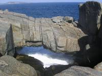
Further along the road is the Gap and Natural Bridge. These two tourist spots are granite rock formations (more bloody rocks) on the coast from by the action of the Southern Ocean. A little bit further on is some blow holes which were working ok when I was there due to the swell running at the time.
At the end of the road is Whale-world. I had actually been to Whale-world in the past so I decided to give it a miss. The fact that the entry cost is $20 had nothing (much) to do with my decision.
Back in town is the replica ship (brig actually) the "Amity". This was only $5 entry hence more my style. The "Amity" is the brig that bought the first British settlers to Albany and Albany was the first settlement in WA. Hence this is the reason to go to all the effort to build the replica brig.
After having a cappuccino in town I decided I had exerted myself enough for one day and so retired back to the caravan park. The pool looked good and the spa was even better. I did catch up with M. again and headed out on the town for a brew and counter meal. Can't remember the name of the pub (The Essex?) but their special pie and pint was magnificent.
The next morning I had to first get the camper secured back on the Ute tray. This was the first time I had taken the camper off this trip. It normally takes a little time to get the Ute aligned with the camper before it can be secured in place. I therefore would normally avoid taking the camper off unless I really want to use the Ute separately.
After this little struggle was complete, I headed out of Albany on the scenic route and pulled into a little surf beach on the advice of Mr. M. the night before. The surf looked good and there were quite a few surfers in the water. I had no intention of having a paddle and was just watching the surf when a cute surfie chick decided she would get changed in front of me. It was the best sight I have seen all trip! Unfortunately I didn't get any photo's to show you.
The drive along the South Western highway starts out mainly in farmland around Albany but this progressively changes to Eucalypt forests with some very impressive stands of Tingle wood and Kari trees. Some of the trees grow right beside the road and I imagine a few of these trees would have had a car or two wrapped around them at some stage. Along this road are some pleasant small town including Denmark and Walpole.
There is a tree top walk in what is called The Valley of the Giants Treetop walk. This tree top walk is located about 25km out of the town of Walpole. This walk consists of metal catwalk spans sitting on steel pylons elevated up to the treetop level. The highest point in the walk is at 40m above the ground. The structure has numerous stays, secured into the ground, holding the structure in place however, the catwalks and pylons are in constant motion not unlike a ship's motion at sea. Not bad value though at $8 entry.
That night I camped in the middle of the Kari's at Shannon national park campground. I liked the wood fired showers although I didn't try them out. I was still in need of a cold shower after the cute surfie chick incident.
The light rain at night would have pleasant except for the bad headache I had. The next days drive was further along the South West veering away to the very South Western point of Australia. The first stop prior to that was at the Bi Centennial tree. This was a giant Kari tree with a rather rickety looking spiral ladder going up to a lookout perch about 60m above the ground. This was, surprisingly, open for anyone to climb if they were game. It looked like you could very easily fall between the rungs so I don't know how the National Park deals with the public liability issue? I would have liked to see someone climb it. I tried the first rung but that wobbled too much for me.
The drive takes you through some forests with huge trees growing. It's not what I would expect to see in WA. The average rainfall in the area around Pemberton is about 1.2m annually apparently. The sign on the way into Lake Pedder in Tas. says, if I remember rightly, the average rainfall is 1.9m. The SW of WA and Tas. therefore have high rainfall in common.
I did notice some Trout fishing in SW WA too. Marron (freshwater crayfish) is popular and is unique to the area. I haven't tried one but apparently it taste like chicken (har, har).
After a brief stop in Pemberton for a newspaper, it was on the road again for a few more k's to Beedelup falls. Not all that spectacular really but apparently waterfalls aren't all that common in SW WA.
The road ends at the Cape Leeuwin lighthouse. This is where the Southern and Indian Oceans meet at the SW tip of Australia. The lighthouse and grounds are open to the public (for a fee of course). There are tours of the actual light but I didn't bother (costs $12). There are plenty of signs and information on the history of the place to look at. There were plenty of people having a look around when I was there too.
An interesting waterwheel is nearby that was used to pump water from a spring to the lighthouse keepers cottages.
I'm finally starting to head north now. I've travelled approximately 6000km so far which is significant in that the car was overdue for an oil change (by 1000km). Extending the recommended oil change interval is not a good idea at the best of times and during a long trip like this I would rather nurse the engine a bit. However, it's a pain doing any maintenance when you're not in your own garage and you're not familiar with any decent mechanics in the area you happen to be in. Also, a lot of caravan parks specifically state that no mechanical repairs are allowed in their parks. I had planned for doing the inevitable oil changes myself, so it was just a matter of finding a campsite that I could do the oil change in at the appropriate time. I found the campsite that night and with no signs around (that I could see) saying I couldn't do any car servicing, I went ahead with the 155 000km service.
The next day I had a late start but a sump full of fresh oil. I really wanted to have a surf here just so I can have bragging rights at saying "I've done Margaret River". The reality is that the surf is rather too large, the reefs to shallow and sharp, and I'm much too scared! The coast between Cape Leeuwin and Cape Naturaliste has numerous surf breaks along its length. The most popular (and scary) surf break is at the Margaret River heads. This is near the small town (village) of Prevelly. There is a town called Margaret River but this is actually about 7km inland of Prevelly. The surf at the Margaret river mouth was huge the day I was there. There were a few people out surfing with many more onshore just watching.
I stayed in the caravan park at Yallingup that night. I had thought the surf would be a bit gentler there but it was not to be. There wasn't much wind that night which seemed to make the sound of the surf even louder and ominous inside the camper.
At the northern tip of this coast is Cape Naturaliste. Naturaliste is the name of one of the French ships that explored the area. The other ship was the Geographe. The lighthouse is usually open to the public-except on the day I was there. There is a museum adjacent to the light which was open and quite interesting. Of interest, the clockwork mechanism that turned the light wasn't replaced with an electric motor until 1978. Prior to the electric motor being installed, the light keepers had to wind up the clockwork mechanism every hour during the night. The light was also kerosene powered up until 1978.
From Yallingup to Busselton, my next nights stop, is only about 30km but there is numerous pleasant beaches and bays to look at. This part of the coast is north facing and doesn't get the big surf like the west facing coast. On its day, the surf can be quite good (so I've heard) however I wasn't there on the right day. It was a very pleasant day in very pleasant surroundings so I wasn't complaining.
Busselton is a smallish holiday town that was used as a shipping port until the early 1970's when Bunbury (about 60km north) became the main port for the area. The jetty has been preserved in order to keep the "feel" of the town. This wouldn't normally be a big deal except this jetty is 1846m long and the brag is that it's the longest wooden jetty in the southern hemisphere. I would have wandered along except that pushbikes weren't allowed and it cost $2.50 just to walk on it. Stingy aren't I!
I'm still about 200km or so from Perth but I'm more or less at the end of the South West area of WA. The journey continues northwards now. I will report on this later on. Regards...
- comments