

Profile
Blog
Photos
Videos

- Blog
- Oceania
-
Location Date Tasmania 1217890800 South Australia 1215730800 Northern Territory 1215212400 Western Australia 
1214521200 Victoria 1207263600 -
Location Date The Kimberley 1214521200 Port Hedland 1212879600 Carnarvon
1211410800 Perth 1210719600 South West Wa 1210028400
.jpg)
.jpg)
.jpg)
.jpg)
.jpg)
The drive from Perth can be done on the Brand highway. I chose to take a more interesting route along the coast. There are numerous coastal communities on this stretch of coast between Perth and Geraldton. Most of these communities are a mixture of fishing, farming and tourism communities. The coastal communities mostly seem to be near a reef which takes most of the sting out of the Indian Ocean swells.
I chose to stay in Ledge Pt. about 150 km from Perth. The caravan park is a "Big 4" caravan park which I'm coming to think of as the "Big Rip Orff" caravan parks. They are generally good quality but overpriced for what you get-a place to park, some power and a shower.
The next day I had to go back to the Brand highway before heading back to the coast and Jurien bay. It was raining and windy when I got there so I didn't hang around but kept on driving north.
Geraldton is a large town (about the size of Devonport) and has a large port exporting Grain, ore and mineral sands. There is also a large rock lobster (crayfish) industry. Nobody I've spoken to has paid the place any compliments which, on past experience, should have made me stop and have a look around for myself. However, I just kept on driving to Coronation beach about 30km north of Geraldton. Coronation beach has a camp ground right on the beach which made it a good place to spend the night. The surf was working well if you were prepared to paddle out over the reef. I wasn't that prepared.
I stopped at Lynton to have a look at the remains of a convict depot. These depots were built to house convicts from Fremantle that were to be used at labour in the colony.
Further along the road are the cliffs along the coast near Kalbari. There are no protective reefs on this particular stretch of coast hence the swell come in unfettered to the cliffs and have helped create some interesting rock formations. Further towards Kalbari are some surf breaks which had some monster swells pounding the coast. The only people surfing were being towed in by a jet ski.
The next day was quite a laid back day and I didn't do a whole lot. I did ride the treddly down to look at the surf at Jakes point. The surf must have been about 7-8 foot as it was noticeably higher taller than the surfers. Jakes is a left hand point break that breaks close to a rock ledge. It's a good place to spectate as it's possible to stand out on the point and watch someone catch a wave quite close in front of you then surf past you. If the surfer gets the right wave, the rides can be quite long too. I really wish I was good enough to surf waves like this. I shall have to do some practice…
The next I day I drove out of Kalbarri further up the Murchison River where there are a few lookouts and walks. I ended up walking the "Loop" walk which took about 2 ½ hours to complete. The Murchison River has created an interesting gorge with many twists and turns. The last time I was here (in 1991) I went on a scenic flight which was a really good way of seeing the river in all it's glory.
That night I pulled over on the North West Coastal Highway again at the Murchison River. The river was no longer in a gorge at this point but was a pleasant place to stop for the night. It was made even more pleasant due to it being a free campsite! There were about 16 people camped there and I did consider crossing over and camping on the other side of the river. I didn't move over and was glad I didn't as the next day I discovered a large group of bikies had set up there camp there for the night.
I am most displeased by the cost of fuel at the more remote Roadhouses. I had to pay $1.89/litre which is about 20c/litre more than the price in Perth. I'm dreading what it's going to cost further north in the Kimberly's.
I pulled into Shell beach on the way to Denham and walked out on the beach. The beach is composed of billions of tiny white shells. When I was last here people used to drive onto the beach but this is no longer possible as the shells were getting crushed and discoloured by the vehicular traffic. The shells are mined and used for chook feed, building and for paths and garden beds. Apparently there are enough new shells being deposited to make this shell mining sustainable. The depth of the shells is 5 metres on some parts of the beach.
Denham is the most westerly town in Australia, not the most westerly point of land. The most westerly point of land is on the opposite side of Denham sound (Shark bay) at Steep point. To get there, I would have to take the Useless loop road (I love that name) which is 280km round trip. There isn't much there so I didn't bother.
I checked into the most Westerly caravan park in Australia and then went down to the beach for a swim. I was assured that even though it's called shark bay, there are no sharks near the beach. You wouldn't think it was named Shark bay because there were No sharks here though would you?
The resort in Denham (appropriately named the Denham Resort) has a great balcony looking over the sea. I remember going there last time I was here so I thought I should check it out again. I can say the view is good, beer is good and the locally caught Mullet was good.
The next day I visited the Discovery Centre in Denham. This building is a fairly recent building the main purpose of which is to house numerous displays regarding Shark bays' World Heritage Area Status. There is also a fair amount of historical information from Aboriginal times on to the Dutch explorations with Captain Dirk Hartog being the first recorded European to step foot in Australia in 1616. There was further Dutch visits then came the English "buccaneer" William Dampier's visits in the late 1600's and also the French (Baudin and Hamelin) expeditions of the early 1800. The town Denham gets its' name from Captain Henry Denham whom charted the area in 1858. There is also information on the guano, fishing and pearling, sandalwood, shell and salt harvesting and sheep farming in the area. Interestingly the main industry in the area nowadays is Tourism although fishing, salt production and pearl farming still occur today. I bet those early Europeans and the Aboriginals would never have picked that Tourism would be the major industry in the area in the 2000's.
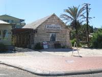
There is a restaurant in Denham that is made from bricks made from the tiny shells found at Shell beach. The sign on the door states that it is the most westerly restaurant in Australia. The sign also points out that the air pockets in the bricks, created by the shells, gives the building good acoustic properties and also insulates the building from the summer heat. I only found two building made from shells however, so there must be some drawbacks to building a house from shells. Maybe the constant sound of the sea would get a bit annoying?
The day was again warm (about 26 degrees) and sunny with light winds. It's really easy to get used to this type of weather! I made the most of it by having another swim in front of the caravan park.
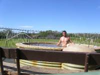
The next day I embarked on the 25km drive to Monkey Mia. Not far from Denham is what is known as Little Lagoon because it is a little lagoon. I had a paddle around in the shallows looking at the baitfish then headed off further down the road to Peron homestead. Peron homestead was a sheep station up until 1993 until it was turned into a National Park. There is a now a programme (project Eden) to remove the numerous species of feral animals that are endangering the native animals. There is no camping at the station but there is a picnic area with a natural artesian spa. The water comes up from 550m below the surface apparently and is said to be about 44 degrees. I tried the spa and found the water quite hot but pleasant and rejuvenating.
Monkey Mia exists almost entirely for the tourists. The name Monkey Mia is apparently comes from Mia, which is the Aboriginal word for place or home and the Monkeys that visiting sailors had. Not exactly sure of the veracity of this name derivation but it's the only explanation that I've come across. The Dolphin feeding is the big drawcard to Monkey Mia and has been the basis for all the additional tourism and infrastructure in the area. Naturally, those in control of the area are very protective of the Dolphins and the feeding is now strictly controlled and supervised. The Dolphin feeding is generally done in the early morning so I checked into the Monkey Mia Resorts' busy camping ground (and put the resorts hot tub to good use) so I could be there for the next mornings' feeding.
Bright and early the next morning (at 7.30 that is) I was on the beach for the Dolphin interaction and feeding. The "show" is more organised and controlled now which is, as I noted previously, to protect the Dolphins and the Tourism industry. One thing you can't do anymore is touch the Dolphins. This actually has benefits as the Dolphins tend to come up very close to the shore and they may touch you. I was not touched by a Dolphin however but I did get a close look at the Dolphins. There are two "Rangers" (I don't actually know what their job titles are) in the water in front of the crowd of people, one of them does the talking over a PA system while the other slowly moves up and down the beach so as to get the Dolphins to swim past the people. After about 25minutes of this, the crowd is instructed to move out of the water. The Dolphins recognise this mass exodus and start blowing and they all move right in close. Another 4 people arrive with a bucket of fish each and spread out up and down the beach. People are then randomly picked from the crowd to come into the water and give a Dolphin a fish. The last fish from each bucket is fed to each Dolphin at the same time to prevent squabbling amongst the Dolphins over the last fish. Once this is done the buckets are rinsed out which lets the Dolphins know it's all over and they rack off out to sea for a while. The day I was there they came back again after 10 minutes and the show was repeated. They generally feed the Dolphins 3 times a morning.
One of the more interesting stories told by the Rangers was how some of the Dolphins have in the past brought fish of their own and given them to the Rangers at the feeding times. The assembled crowd of course all went "ahhh.." in unison at hearing this little anecdote. I thought later that perhaps the Dolphin was just showing the human what type of fish they actually want to be fed?
The Dolphins at Monkey Mia are Bottle nosed Dolphins. The Dolphins here are related to the first Dolphins in Monkey Mia that fishermen used to feed on a regular basis. Dolphins tend to stay in packs of 5 or so adults and possibly a calf each (Dolphins only have one calf at a time). Dolphins also tend to stay segregated i.e. the boys and girls only get together when it's time to make little Dolphins (or maybe that's just the Aussie Dolphins?). The Dolphins that come into the beach at Monkey Mia are all females-the males are too big and aggressive and for this reason are deliberately not fed.
The Dolphins are individually recognisable by the shape of their Dorsal fin. The fins are generally straight at birth but over their life (Dolphins live to around 35-40 years) the Dorsal gets damaged by predators and passionate male Dolphins. The Dolphins have all been given names and a Dolphin family tree is known for the Dolphins at Monkey Mia.
Besides Dolphin feeding, there are a couple of yachts in Monkey Mia that offer tours. There is also hire boats available too but these things all cost money so I went for a swim and then read a few more chapters of my novel instead. I did also enjoy a beer or two on the beach at sunset.
When I was heading back to the North West Coast highway from Monkey Mia, I decided to pull into Hamelin pools campground for the night. The caravan park is situated at the site of the old Telegraph station building which normally is open for inspection but was closed when I arrived due to water damage from recent rains. A short walk from the caravan park is the Hamelin pools Stromatolites. Stromatolites are ancient relics of life forms that resemble the simplest form of life found on earth 3.5 million years ago. The interpretation signs say the oxygen these life forms produced played an important part in the evolution of other life forms on the planet. There is a viewing platform over the water to allow you to have a close up look at the Stromatolites. They are really nothing spectacular to look at however and if I wasn't told they were actually living organisms, I would have thought they were unremarkable brown rocks.
I'm now glad I didn't start this Safari any earlier. There had been some serious rain here about a month ago. The Shark bay are doesn't seem to drain too well-something to do with being close to sea level and the water table close to the surface. The Hamelin pools caravan park had to close for 2 weeks due to flooding and there was still evidence of the flooding. This wasn't good for business as the caravan park was closed during peak school holiday period. Interestingly too is that the park doesn't have mains power and instead has to run a generator. This generator costs about a $100 A DAY to run which is a pretty high overhead particularly when the place is flooded and there are no customers.
The run North up to Carnarvon is about 220 km. There is one roadhouse along this stretch and not much else. I pulled in to the roadhouse as I was getting low on fuel. When I saw the $1.95/litre price I didn't stop and decided to try and make it to Carnarvon. It turned out I didn't have enough in the tank but fortunately I had a jerry can full of fuel in the camper which I had to stop and put in the cars fuel tank. You will be glad to hear my plan paid dividends as I was able to purchase fuel in Carnarvon for $1.74/litre. I saved myself about $14 hence felt pretty pleased with myself!
Besides having cheaper fuel, Carnarvon is a pleasant town that has a nice, wide main street with plenty of trees. The 1 Mile jetty was the main port for the area but is no longer used. The Jetty has undergone a change to the metric system in recent times (it's now about 1 kilometre long) with some local lads kindly lighting a fire on the jetty and destroying a large section. I am told the repair will be undertaken shortly.
Carnarvon sits on the Gascoyne river which supplies the town with freshwater along with some underground aquifers. This area of Australia is also sometimes referred to as the Gascoyne area of WA. A sign on the road on the way here says you're passing the 26th parallel and entering Northwest WA. I have now come to the conclusion I'm not really in the Mid West WA anymore so I'd better end this blog here. Of course I will take this up again a little further up the road. Bye for now!
- comments