

Profile
Blog
Photos
Videos

- Blog
- Oceania
- New Zealand
-
Location Date Dargaville 1302303600 Northland 1302217200 Coromandel 1302217200 Wellington 1301785200 Napier 1301785200 Rotorua 1301785200 Nelson 1301097600 Hokitika 1300320000 Wanaka 1300060800 Te Anau 1299715200 Dunedin 1299196800 Middlemarch 
1298678400 Cxlyde 1298160000 Lake Tekapo 1297641600 Mount Cook 1297641600 Christchurch 1297209600 Kaikoura 1296691200 Picton 1296518400 Taupo 1296086400 Raglan 1295740800 Auckland 1295654400

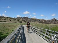
Otago Central rail Trail
The rail trail support facilities are excellent. You can have your bags delivered every day to your accomodation at your next stop off point. In our case, as our "accomodation" had 4 wheels & was mobile we organised for one of us to be picked up every afternoon at our arrival point and to go back to the departurepoint by shuttle & bring forwards the van
Day1 Clyde to Omakau 36km
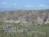
Fantastic weather, clear blue sky & 24C in a semi arid countyside very reminiscent of Provence. The mountains to the North West act as a barrier and make Central Otago semi desert despite our very southerly latitude The hills are even covered in thyme - originally planted by the first settlers, it has spread everywhere. Despite this the Manuherikia river (+ all the farm land it irrigates) which follows the rail trail is a green & lush contrast.
Most of the day was an uphill pedal but being an ex-railway track the gradient is very gentle & there was no wind ( more of this later - wind can bea BIG issue up here on these vast wide open plains).
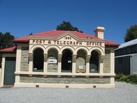
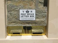
Arrived in Omakau - as expected, it's just a few houses clustered around a pub & a garage/agricultural repair shop. Just 2km away we visited the old gold mining town of Ophir - some very quaint little buildings remain from the boom days, including the Post Office which is still in service including it's original interior with Victorian fixtures & fittings. Found a great spot to "freedom camp" by the side of the river.
Day2 Omakau to Oturehua 32km
We will be having a contest on our return with a prize for the person who can correctly pronounce "Oturehua"(it's not pronounced like you think it is). We are having all sorts of problems with the maori place names. We can't pronounce them & we can't remember them. Driving around is a nightmare as the navigator can't pronounce the place we're supposed to be heading for and the driver can't recognise it anyway, even if it were pronounced correctly. So most places end up sounding "wai……mmm……aka ? ? !!!"
Back on the rail trail another gorgeous day, even hotter at 27C and the dreaded wind is thankfully still keeping away. We planned today to be our shortest day in km as it was 100% uphill.
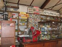
Arrived in Oturehua - a very dusty crossroads with as expected a few houses and an interesting old general store. Didn't fancy parking there for the night so after we'd picked up the van we drove to St Bathans, another old gold mining town. This was 25km down a gravel track deep in the mountains and the old town has nowadays shrunk from former glory of several thousand citizens in the 1860s to a population of about 9, most of whom work in the Vulcan Hotel which has allegedly a haunted room. The gold mining produced a huge hole in he ground which has become a crystal clear blue lake. We got some fantastic photos of it, went for a refreshing swim and parked there for the night.
Day 3 Oturehua to Daisy Bank 48km
Weather changed during the night. Dull & overcast and a strong gusty WIND. Worried about having it in our faces for the longest day of the trip. 48km to do, first 8km uphill to the highest point of the journey then 40km downhill. In the end no problems- the wind was behind us virtually all day so we rattled off the 48km and found somewhere nice to freedom camp near to a river.
Day 4 Daisy Bank to Middlemarch 44km
From Daisy bank we leave the arid Central Otago area and come down into the coastal climate area i.e. it can & does rain regularlarly - and it did. Most of the time we were just below the clouds with non stop rain & the wind had turned and was driving the rain into our faces cancelling out the advantage of the downhill slope. Stewart was VERY grumpy and we were soon soaked to the skin. Definitely NOT the best day of the 4 , but we made it to the end and a relaxing weekend.
- comments