

Profile
Blog
Photos
Videos

- Blog
-
Location Date Iran 1255129200 Uzbekistan 1253142000 Kyrgyzstan 
1251846000 China 1250204400 -
Location Date Sun, 30 August 2009
1251611442 Sun, 30 August 2009 1251609693
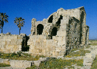
Hey.I will now tell you about my second day in Turpan (17th August).That day we went to see the Jiaohe ruins. The city of Jiahoe was, for the most part, controlled by the kingdom of Goachang (the other ruins) but apparently it became the regional administrative centre during the 8th century BC which is why a large part of the ruined town was governemnt buildings.The ruins are situated on on top of a 2 km long steep-sided plateau, inbetween 2 halves of a forking river.Its a great position. If we looked down on wither side of the plateau to the valleys below we could see the running water, emerald green trees and crops and the Uygurs harvesting them.These ruins were better preserved than Gaochang, but they are still not as telling as,for example, a Roman ruined city.However I could get a feel of the residential areas as I meandered down the narrow streets and noticed how close together the houses had been built (alomost on top of one another).It must have been chaos during the times of the Silk Route. You could also distinguish enough between the wealthier residences which were situated nearer the government and temple districts and seemed as if they had had a proper structure with rooms and the poorer houses, which was located near what seemed to be specialist buildings for trades, like blacksmiths and metal workersand were little more than hovels or small caves with one room and a rounded doorway.All the roads of the town ended in the Temple District that was next to the Government District but set apart from other buildings. Here we could see grand arched entrances, high walls and a big altar where a massive Buddha would have once sat.After the ruins it was straight to the Turpan Karez (irrigation site). Apparently there is a whole network of these throughout XinJiang and they date back 2000 years, which shows just how civilised they were.The Turapn Karez has been spruced up and turned into a tourist attraction, but it is still a working irrigation site.It is made up of a network of underground channels carrying water from the glaciers on the Tian Shan mountain range.Wells and vertical shafts are dug in strategic places, bringing water to small channels on the surface that run through fields and towns. Apparently many ancient Silk Road cities (being of a particularly dry climate) relied on these systems and someone told me the idea came to XinJiang on the Silk Road from Ancient Persia.The site was lovely.Underground, where the channels were was so cool and there were statues depicting the evolution of water-drawing methods over the years.There was a nice fountain and shady areas (the whole site was under grape vines), where you could stretch out on the outside beds.For 5 yuan I had a cup of fresh grape juice which was delicious. Apparently the grapes here have the highest sugar content in the world.Anyway I have to go and look at some Kyrgz handicrafts now so I will update more soon.x
- comments