

Profile
Blog
Photos
Videos

- Blog
-
Location Date New Zealand 
1329177600 Victoria New South Wales Cook Islands -
Location Date Franz Josef 1329177600 Christchurch Central Queenstown Dunedin Pohara
Momorangi Bay Whitianga
Friday 24th February
In the morning we parked up on the headland, in the rain, overlooking the campsite hoping to see the Hectors Dolphins in Porpoise Bay but we were to be disappointed.
Today we were going into the Catlins National Park to see the Cathedral Caves and as we found out yesterday, had timed it perfectly! They can only be accessed at low tide which was at 10.56am today. On the way there we saw a waterfall called Niagara Falls - I'm not sure if it was because they resembled the famous falls or because the village they were in was called Niagara. The falls are normally around 6ft high in a straight line across the river, but the rain had swelled the river so much that we could only see the top 12 inches of the falls, and the river was brown with the sediment brought down from the surrounding hills.
The rain stopped as we parked in the Cathedral Caves Car Park. The access to the caves is across private land so there was a charge of $5 (£2.50) to use the track down to the beach. It was another superb 2km/15-20 minute rainforest walk with tree ferns 3 or 4 times our height. We emerged onto a wide golden beach and walked for another 10 minutes along the beach to the caves. It was actually one cave with 2 entrances backing into the cliffs meeting in a 'V' shape. The ceiling of the cave reaches 30 metres (nearly 100ft) in a well-defined 'cathedral' shape. The caves looked as though they filled up to about 4ft with the high tide as there was a layer of barnacles around that height together with a strange purple hue - some sort of sea lichen type plant that grows in the darkness of the caves? The tide had started to come in as we walked back across the beach to the track up through the rainforest, and it had also started to rain again.
Just up the road we pulled in at the Florence Hill Lookout which was high on a cliff overlooking Tautuku Bay, a huge crescent shaped expanse of golden sand. It wasn't until someone walked along the beach that you realised how big it was. We stayed here and had lunch, being rocked about by a strong wind!
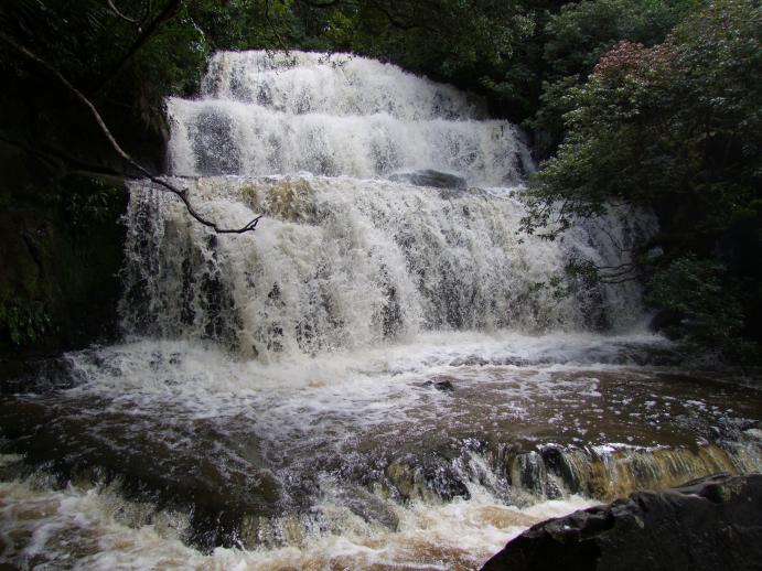
The next stop on the map was Purakaunui Falls, driving through exceptionally English looking countryside with green grass, trees, cows and sheep in fields. There are very pretty pictures of the falls in the tourist leaflets - an upside down fan shape of little rivulets trickling 20m (65ft) over three distinct tiers - but today it looked like a wedding cake with three solid tiers of white water cascading down over the rocks. Very impressive waterfall though!
The last tourist visit we made today was to see some 300 year old Totara trees. We followed a footpath from the tiny gravel pull in, across farmland into the Nature Reserve where they stood. The path then went in a loop through the forest. This was not rainforest this time so the trees were slightly different. The Totara trees are very tall and the oldest one had a huge girth. We were followed around the forest by a few native NZ Fantails. These birds are a little bigger than a sparrow and have about 8-10 larger tail feathers that spread up behind them like a fan. They were following us to catch insects that we disturbed as we went along - so the North Islander couple we met in the forest told us. The birds came quite close, but moved so quickly that it was hard to photograph them.
We drove on to Dunedin, and were caught in a traffic jam (= 5 cars!) because the local police were breath testing all the drivers. Martin had to say the numbers 1 to 10 into a hand held machine, which then showed he tested negative for alcohol.
We spent the night in Dunedin in another rather cramped Holiday Park.
Saturday 25th February
After a false start in which we ended up driving into and then immediately out of Dunedin by taking the wrong road, we managed to park and walk for what seemed to be miles, past the university student accommodation, into the town. The centre of the town is an octagon in the middle of which stands a statue of Robert Burns. Another octagon of streets surrounds the first one and the rest of the streets radiate out from that. We were there on a Saturday (busy enough) and also, so it turns out, on the first week of the new students arriving at the university. So the town was even busier than normal with groups of students exploring the town too!
Dunedin was originally named New Edinburgh, but its name was later changed to Dunedin (Scottish Gaelic Dùn Èideann). Dunedin was not my favourite place, (but we were only there a couple of hours and one of those was in a café for lunch) but it was good to see the contrast between this and the smaller towns. On the way out of Dunedin we found Baldwin Street - the steepest street (i.e. residential) in the world - and took pictures along with other tourists at the bottom. We watched some of the people who had walked to the top; it looked like quite an effort, perhaps we should do that next time we are in town! It is a cul de sac without a turning point at the end so you cannot drive up it (only those who live there and have driveways can safely go in and out). From the main road it slopes gently at the bottom and then halfway along rises steeply up with a gradient of 35% (1 in 3).
Dunedin is on the south east coast and we were now travelling north along the coastline before going inland again towards Mount Cook. Our first stop was unscheduled at what Martin thought was a layby, but turned out to be the beginning of a road, so we kept going. I could see from the map that it ended at the shore where there was a Recreation Reserve (parking and sometimes toilets) called Shag Point. We parked and wandered across to look down over the cliff. There was a lovely rocky 'V' shaped cove where lots of NZ fur seals were lazing on the rocks! We stayed to watch for a while and then noticed a big grey 'rock' moving slightly…it was about 20 times the size of the seals and it waved a flipper in the air - it was and Elephant Seal. HUGE! It didn't move very much and was on a ledge well away from the sea and looked very dry; perhaps it had come in at high tide and was stuck there waiting for the next one. We drove round to the car park at the next bay and then saw the shags on the rocks after which the area had been named. Martin and another man helped a French gentleman get his small campervan out of a ditch (his wife was not very pleased with him!).
Our next (scheduled) stop was at the Moeraki Boulders where we had fun on the beach taking photos of this natural phenomenon. They were huge spherical boulders thought to have formed like pearls in layers. Maori legends explain them as food and water stores in gourds that were washed ashore from an ancient canoe wreck at Shag Point.
We had crossed a small stream running down to the sea to get to the boulders and whilst we were there the tide had started to come in. The stream was flowing wider now as the tide came in to swell it. I took my shoes and socks off and waded across. A group of people further upstream were trying to bridge the stream with large pieces of driftwood. One young man just waded in with all his clothes on to get the driftwood stacked in the right place! Martin and others crossed the new bridge when they had finished.
A few miles on we stopped for the night at Oamaru. We managed a successful Skype with my Mum, Dad and Nan, it was mid-morning for them and late evening for us, I'm sure I woke half the campsite up with my loud talking…well they were on the other side of the world!
Sunday 26th February
In the morning we spent a few hours in Oamaru - a wonderful place! A Victorian town first settled in the gold rush era and then progressed to grain imports. There are no trees in the area so they looked for other materials to build with and found limestone. They were able to create intricately carved buildings with the more prestige businesses like banks having majestic columns fronting their premises. The main street is extra wide because the wagons - pulled by bullock trains not horses - had to be able to turn in the street. As it was Sunday and it was a small town, most of the modern shops in the high street were shut for the day. The Victorian Precinct however, was alive with 2nd hand stalls, craftspeople, music and the local farmers/producers market. Some of the townsfolk (possibly the local theatre company who had their meeting place advertised nearby) were dressed up in Victorian costume. In the local producers market I bought some local Whitestone 'Windsor Blue' award winning cheese - a blue cheese made with cream rather than milk, yum! Fudge, and plum preserve also made its way into my bag and whilst checking out the fruit stall I noticed they were giving away a sample bag of fruit if you could find the password C…. T…. It was Crimson Tide, a variety of red fleshed pear. I got my bag of sample fruit which included a peach, nectarine, plums and apricots. Afterwards we went to the i-site to look at the weather forecast for the next few days. When we were there we watched a short film about the town and local area, and Martin bought a cool dude bush hat!
As well as its Victorian architecture, unrivalled in New Zealand, Oamaru is also famous for its Little Blue Penguin colony which comes ashore each evening. The sign in the i-site said that 86 had come ashore last evening - it was advertising tickets to see them. We decided not to pay the $20 each for the commercial tour (the shore where they come in is probably private land so the owner can charge), instead wanting to remember the penguins we have already seen completely in the wild.
We reluctantly left Oamaru and stocked up in the supermarket at the edge of town on the way out. We were now inland and the mountains once again started to appear in the distance. We were headed towards 2 big lakes linked by power stations. Lake Waitaki was first and the road went over the dam between it and Lake Aviemore. Both lakes were a deep turquoise blue - we now know that the turquoise lakes are fed by glaciers and the glass green lakes are fed by rivers. We took the long back road around Lake Aviemore and stopped to have lunch at a nice scenic spot. It was sunny and hot and we even got the chairs out to sit at the side of the lake to eat. After a grey morning it was looking good for our trip to Mount Cook the next day.
We followed the road around the rest of the lake and noticed there were several areas where permanent caravans and tents had been set up. I later found out on the internet that it only costs $280 (£140) for a season ticket to leave your tent or caravan there. The perfect place for a weekend getaway, especially if you don't live too far away.
On the map I spotted a feature called 'Clay Cliffs' I thought I had seen a picture of them in a leaflet and wanted to have a look in real life. I directed Martin down the road towards them. The map showed that there was 4km of gravel road to get to them and we travelled slowly down it as it was very loose and bumpy. We got to the gate for the Clay Cliffs and it said there was another 4km of gravel track over private land to get to them! We paid our $5 into the honesty box and went through the gate. The road was even more bumpy than the last bit so we went even slower. Eventually we got to the cliffs and I took loads of photos. They looked like hundred foot high groups of termite mounds coming out of the cliffs, formed by weather erosion of the soft white clay cliffs. Quite spectacular, as the hills and mountains in the surrounding area appeared to be made from hard rock, and these stood out because they were so pale in colour. When we finally got back to the main road we made our way to Lake Ruataniwha Motor Camp. As we approached the camp we could see snow-capped mountains in the distance. I eagerly took pictures thinking the highest one was Mount Cook… it wasn't, but I didn't find that out until the next day.
Monday 27th February
We left early as we wanted to be able to park easily at Mount Cook. 'Early' for us is up about 7am and leaving the site between 8 and 9am and finding somewhere nice on the way to have breakfast. 'Normal' time is up about 8am, having breakfast on site and leaving at 10am - this is the 'checkout' time at nearly all sites. There is no campsite at Mt Cook, only hotels and lodges.
Aoraki Mt Cook is the highest mountain in New Zealand at 3754m (12,316ft). It is one of the few places where the Maori name precedes the English name; this recognises its importance to the Ngāi Tahu Maori tribe of the area.
We were surprised that the car parks were not already full, as this is a major tourist attraction. But unless visitors had stayed at Aoraki Mt Cook the night before, most of them would have travelled further than us, so we had timed it right. We found a place to park with views of the mountain and had breakfast. We then spent an hour or so at the information centre reading the displays and stories about the early explorers and mountaineers - those that went up the face of the mountain 5 different ways and with only hobnail boots and tweed jackets! We found the details of the walk we wanted to do - the Red Tarns Track, as recommended by Sam; 'go over the bridge, up a steep hill and you get amazing views of the village and the mountain' - sounds good. Found the start of the track and off we went over the bridge and up some steep steps…and then some more steps…and some more…and more. I'm surprised it wasn't billed as the 'Longest, steepest, highest flight of steps in New Zealand'! The guide book says 2 hours return - I think it took us 2 hours to get to the top (with stops…to admire the views of course). The track was cunningly constructed so that you couldn't see more than about 20 steps in front of you, then it turned a corner …and there were 20 more steps! It was hard work, and it was hot and sunny, but it was worth it in the end. The views were amazing and the sense of achievement was immense. We sat alone at the Red Tarns (so called because of the red leaf pond weed that grows in them), and watched a man with a large rucksack (who had passed us on the way up) continue to the top of Mount Sebastapol and disappear over the top. A short while later 3 girl backpackers came down the same way the man had gone up. We sat for a while longer enjoying the view, getting our breath back, drying the sweat, and counted our blessings. Aoraki Mt Cook was in full view, and we had blue skies and sunshine. It is not very often that the top is seen in all its glory - its name was thought to have meant 'cloud piercer'. Photos taken and feeling rested, we made our way back down in less than half the time it took to go up. We were to feel the effects of the day in our calf muscles for several days after!
We travelled back on the same road we had approached Aoraki Mt Cook as the road does not continue on through the valley. At the end of the 55km road we headed towards Lake Tekapo where we were stopping for the night.
Tuesday 28th February
At Lake Tekapo is the University of Canterbury's astronomical observatory on Mount John. We saw why it was the ideal place as last night we once again could see the Milky Way in the clear night sky.
Just down the road is the Church of the Good Shepherd, built in 1872, a joint effort of early pioneers of more than one denomination . It is one of the most photographed churches in New Zealand. I took my own photos of the tiny church and sat inside for a few minutes looking out over the altar through the large window that frames the stunning views of the lake and mountains.
Close to the Church of the Good Shepherd is one of New Zealand's best known public monuments, a bronze statue of a New Zealand Collie sheepdog erected in 1968 as a reminder of how hard the dogs worked on the farms in this area in early days.
It wasn't long after we had left Lake Tekapo that we heard the sad news that my lovely, gentle, sweet, kind Nanny had passed away a few hours before, only a couple of weeks after her 90th birthday.
Wednesday 29th February
Yesterday afternoon we had stopped at Christchurch, almost exactly 1 year on from its major earthquake. The city was still quiet and a 'red zone' (cordoned off exclusion area) still exists around the centre, where they are taking the buildings down one by one. We had a late lunch at 'Restart', an area just outside the city centre where nearly 30 retailers have set up in brightly coloured shipping containers to keep their businesses going.
Tonight we stopped in Kaikoura, a town famous for the dolphins and whales that frequent its shores. We were booked on a 7.45am(!) whale watching trip.
We were both seasick (despite tablets and pressure point bands), but we weren't the only ones that were affected. It did detract from the experience but I'm sure we'll look back and be glad we did it. We saw 2 sperm whales and Wandering Albatross in the couple of hours we were on the boat. It took us another couple of hours to recover whilst we wandered round Kaikoura; not wanting to stop in case our legs wouldn't work again (on top of calf muscles aching from the climb up and down Mount Sebastopol)!
Then we were back on the road heading towards Blenhiem. As we left Kaikoura I spotted a small shop (a well-equipped 'shack' at the bottom of a garden) advertising freshly cooked crayfish. I had just found out that 'kai-koura' literally meant 'eat crayfish' so I stopped and bought one, just to support the local producer of course ! Crayfish are like small lobster and turn the same pink when cooked. Very nice, not as strong a taste as lobster, but just as expensive !
The coastal drive was again spectacular and we stopped at Ohau Point Lookout on the cliff to get a good look, not realising that it was the viewing area for yet another Fur Seal Colony. This was the biggest one we had seen so far and the most entertaining! The shore was full of large rock pools and the pups were splashing about having fun. We were still feeling a bit dazed from the morning's excursion so we agreed to have a longer stop at the next quiet pull in (Ohau Point was busy with people watching the seals). Not far down the coast was a large gravel car park at Paparoa Point down on the shore and we stopped there for a couple of hours. There were a few people taking photos so I went to have a look. There were a handful of Fur Seals on the rocks on the shore, some only a few feet away. They looked bigger than the ones at Ohau Point…perhaps these were the males escaping from the females and pups down the coast! Signs all along the coast tell you to keep 20 metres (65ft) away, but it was difficult here as they were closer than that to the car park. They didn't seem to mind people being so close but kept their eye on you as you walked past.
We stopped at Blenheim Top 10 Holiday Park for the night. At least half of the places we have stopped have been Top 10 Holiday Parks. They usually have a small motorlodge/motel, basic cabins for backpackers, larger cabins with kitchens for families and sites for motorhomes and tents. They also have toilets, showers, large kitchens with tables and chairs - useful for those with small tents, or campervans with just beds - a laundry, and free gas barbeques. They have cost between $30-$48 (£15-£24) per night.
- comments