

Profile
Blog
Photos
Videos

- Blog
-
Location Date New Zealand 
1329177600 Victoria New South Wales Cook Islands -
Location Date Franz Josef 1329177600 Christchurch Central Queenstown Dunedin
Pohara Momorangi Bay Whitianga
Sunday 19th February
(Happy 45th Birthday Jayne Gray! Did you like our card?)
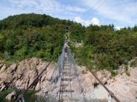
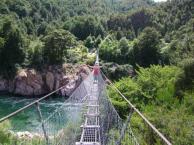
A nice lazy morning because we didn't have to leave the campsite until this afternoon after the jetboat trip. The Skippers Canyon Jetboat minibus collected us from the campsite just after midday. 10 other people had already been picked up on the way out from Queenstown. After a few minutes we were at the start of Skippers Canyon Road. Although the road is a public road it is 'unsealed' (not tarmac-ed), and it is a single track 16.5 km (10 miles) long with only a handful of passing places. There is a notice at the beginning to say that rental vehicles are not insured on this road. The road is there because of the gold rush of 1862 when one day 2 Maori shepherds found 25lb of gold after they rescued their sheep dog when it was washed downstream. Within 2 months there were over 4 thousand miners in the canyon. Access was originally down a footpath into the canyon. The main problem facing the miners was lack of food (no land mammals remember?), shelter (treeless mountains in those days) and fuel (no trees, no wood). A few enterprising individuals therefore made their money from bringing in supplies (mainly goats and coal). It took 22 years for the road to be carved from the side of the canyon using only hand drills and black gun powder. There is no trace of any settlement in the canyon as the miners slept under canvas, and any semi-permanent buildings were demolished and the materials used again for another purpose. There are only 10 people living permanently in the canyon now dotted here and there, power is by diesel generators and bottled gas is used for cooking.
The minibus took 45 minutes to reach the Shotover River at the bottom of the canyon. If you haven't checked out the photos on the website link I gave last time, a couple of my photos will give you an idea of the road and the path it takes down Skippers Canyon. It wasn't as scary as I had imagined, but I did go to sleep last night telling myself that this company have been operating for 15 years without any accidents, and to just look at the scenery. It was an incredible drive and somehow I had managed to be on the side of the minibus that was on the outside of the road (with the sheer drops beside me).
At the riverside we donned our lifejackets and got in the jetboat. 30 minutes later we were back at the riverside having had an awesome ride!!!! If you ever get the chance, DO IT!
When Sam and Laurie went to Skippers Canyon, they white-water rafted downriver to their final destinationand didn't travel back through on the Skippers Canyon Road, but we did. The journey back was slightly more eventful as we met a few vehicles coming the other way, including a convoy of 4 minibuses, 2 more minibuses with full canoe trailers and a few cars. We seemed to have right of way and each time all drivers concerned were patient and careful. We also had a brief stop at an old (unprofitable) Bungy Jump operation on the way back for some photos.
Once we had been dropped off at the campsite, we resumed our own journey and made our way to Arrowtown, an old settlement town a few miles down the road. The village is filled with 200+ year old buildings still in use with today's cafes, shops and businesses. It was here that the Skippers Canyon goldminers had their gold assayed (tested, weighed and bought).
We stopped tonight at Mossburn Country Park, which was really a smallholding (tame animals including llamas) with a modern toilet/kitchen block. They also had 'cabins' which held no more than bunkbeds and a table and chairs; Backpacker accommodation. We have seen them before, but these were 'vintage' and reminded me of 1970s playing field changing rooms (before portacabins) only smaller!
9pm, and a pale pink sunset over the mountains on one side of us, and yellow tinged clouds on the other side promises good weather tomorrow. When Martin went out for his last cigarette before bed, he came back in saying the skies were so clear and dark, and no light pollution meant you could see the Milky Way. We stayed outside for a few minutes more marvelling at the sight of the 'milky' band of millions of stars across the night sky. All the other constellations (no idea which was which) were so bright and clear too.
Monday 20th February
Blue skies with sparse white clouds greeted us in the morning and we ate our breakfast outside in the hot sunshine.
We drove into Te Anau town at the south end of Lake Te Anau (the largest lake in the South Island). It was pretty around the edge of the lake with mountains in the background.
Lunch was in an open space at the side of the road where we once again had mountains all around us. The road then took us along the east edge of the lake for nearly 20 miles where we then drove through forest as the lake continued on for another 20 miles a couple of miles away to our left. Along this road there were several Dept of Conservation campsites, some with just fresh water and others with composting long drop toilets, and one with a modern building with vending machines, tables and chairs and toilets. We had pulled into nearly all of them to check them out for a rest break, but they were mostly in the trees with no view so we left. We had almost given up hope of somewhere with a view when we pulled into the last one at Lake Gunn, ah, this was more like it! A small gravel beach alongside the lake. It started raining, and the peaks disappeared into the clouds but it was still lovely. There were a few small campervans there when we arrived and when we left a couple of hours later it was packed. The DOC Warden arrived just as we were leaving to check everyone had self paid* and said last night there were 31 'units' (tents/vans etc) on the site. The DOC guide book said it only had 10 pitches! Worse still, at Cascade Creek, the site just down the road there were 78 units crammed into a 20 pitch site.
*At the DOC campsites you take a form and envelope from the roofed noticed board, complete the form and tear off the receipt at the bottom, then put the form and your payment on the envelope and post it in the payment box. The fees are between $5 and $19 (£2.50-£9.50) per person (children half price) depending on the facilities at the site. There aren't any pitches marked out, so you park/pitch where you can.
We had read that the road to Milford Sound was stunning, but from Te Anau to Lake Gunn it had been mostly through the trees. Now, however, the trees were less dense and we were spotting huge steep sided mountains of grey black rock towering above the trees. As we got closer to Milford Sound we could see patches of snow or ice on the peaks and a few long skinny waterfalls. 11 miles from Milford Sound we drove through the Homer Tunnel - carved through solid rock 1.2km long and a gradient down, of 1 in 10. Martin didn't notice the sign at the entrance saying the traffic lights would be off between 6pm and 9am, and was fearful of meeting anything coming the other way as we were only just clearing the height in the middle of the tunnel! It was exceptionally dark in the tunnel and our full beam headlights did not light the way very well. We descended slowly and carefully, breathing again when we got to the end! It turns out that nearly all the traffic through the tunnel is for the Milford Sound cruises, which close at 4pm, so most of the traffic had left the Sound area already. It was still raining when we arrived at Milford Sound Lodge & Campervan Park (which should be renamed Campervan Car Park, as about 20 large campervans were crammed together in a gravel car park). This was the first site we had pre-booked and we were glad we had, as judging by the DOC sites back down the road we would have been driving 100 miles back where we had come from to have found somewhere to stay for the night. That would not have been good as we were booked on an 8.30am Milford Sound Cruise the next day!
Tuesday 21st February
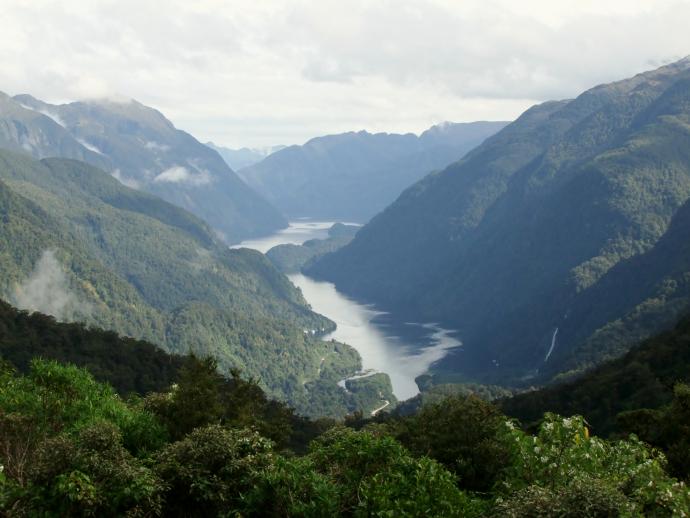
It had poured with rain all night. At least it had helped to drown out the sound of snoring in the next campervan! It was still raining this morning, and the clouds were covering everything. We made our way to the cruise terminal and got our boarding passes. We had booked to take the cruise on a small boat with Mitre Peak Cruises. It held 40 passengers but today there were less than 20 of us which was brilliant as we could move around the boat and easily take turns taking pictures in all the best places. Because of all the rain the waterfalls were spectacular. They were like white ribbons cascading down the cliffs everywhere you looked. The Captain took us towards the cliffs and nosed under one large waterfall on the way out and another on the other side of the Sound on the way back in. When we got to the Tasman Sea at the end of the Sound the swell was rocking the boat considerably, and a couple of waves broke over the bow. We were both glad when the boat turned around and got back into the shelter of the Sound. At one stage for a few minutes the sun shone through a tiny hole in the clouds and there was a low rainbow against the cliffs across the other side of the Sound. We passed a few Fur Seals lazing on the rocks on the way back, but there weren't any dolphins today. Although the cloud cover was low and we probably didn't get the full effect of the height of the walls of the Sound, the trip was well worth it and highly recommended.
Although the inlets in this area are named 'sounds' they are actually 'fiords' - they were named by Europeans who didn't know the difference. A Welshman named Milford Sound after his home town of Milford Haven.
The rain eased slightly whilst we were out on the boat and even stopped altogether a couple of times. By the time we got off the boat the clouds seemed to have cleared a touch. We had a cup of coffee in the campervan and stayed for another hour watching the clouds clearing little by little. It didn't clear completely and after lunch and a few more photos we left. We stopped at 'The Chasm' to view the shaped rocks carved out by the Cleddau River on its way down to Milford Sound. In the car park we got our first look at a Kea (olive green parrot) up close - there were signs saying not to feed them - as it hopped around the car park approaching each car and van in turn. They can be destructive and rip the rubbers from car windows etc (like the baboons at Longleat) so were not to be encouraged with food. We then went back up through the Homer Tunnel, complete with working traffic lights. As we came out we stopped to take some photos of the high peaks around us and marvelled at how the tunnel had been conceived and built in the 1930s.
We stopped tonight in a small motorpark/campsite called Possum Lodge on the edge of Lake Manapouri (the second deepest lake in South Island). An improvement on last night's site but this time we were right next to the laundry and six rows of washing lines, so we took advantage and got some of our washing done. Before tea we walked to the lakeside only a minute away. The best lakeside so far Martin has decided.
Wednesday 22nd February
Another early morning, but only a 10 minute walk from the campsite to the Real Journeys' tiny wharf for the first part of the trip. We were going across Lake Manapouri on a smallish boat to the 22km (13.5 mile) Wilmot Pass, where we would then have a coach ride to the Manapouri Hydroelectric Power Station (New Zealand's greatest engineering achievement) and finally a catamaran through Doubtful Sound to the Tasman sea and back again, with everything (except the power station) in reverse. The weather was clearer than yesterday, and although we didn't know it yet, the Tasman Sea was incredibly calm. The boat trip across Manapouri Lake was beautiful with the layers of mountains silhouetted against the sky. We passed a tug boat pushing rather than 'tugging' three platforms with a couple of flatbed trucks, a JCB type digging machine and a petrol tanker. All the equipment, supplies, workers etc. for the Doubtful Sound area goes across Manapouri Lake and then the Willmot Pass. The pass is a land locked road which just links the lake and the sound, there is no other access to the road, it was built in the mid 60's to provide access for the heavy equipment used to build the power station. This was brought in by sea, through Doubtful Sound and across the Pass. Floods, snow and landslides meant it took 2 years to build instead of the 12 months predicted. The power station was built over eight years (1964-1972) to provide electricity for an aluminium smelter 121 km away, but 15% of the electricity goes to the national grid. The tunnels and cavern housing the power station were all excavated using drill and blast methods; holes were made by hand with massive pneumatic drills into which explosives were placed to blast through the rock. 1800 workers were employed on the project and many of them lived on the Waganella, a 1930's first class passenger ship, which was moored in Deep Cove at the head of Doubtful Sound. The 2km (1.2 mile) long 9 metre (30ft) wide access tunnel which we drove down in the coach encircles the workings of the power station and spirals round it one and a half times, descending at an incline of 1 in 10. At the bottom of the access tunnel we walked a short distance to the viewing platform above the machine hall. A guide explained how it all worked; the water comes from Lake Manapouri and is fed through the power station and then exits through two 10km (6 mile) tunnels also dug through solid rock to Deep Cove in Doubtful Sound. As you can probably tell, we thought the most interesting things were about how it was built, especially as we could see the countryside they had to overcome and the rock they had dug through to do it.
After the visit to the power station the coach travelled slowly along the Wilmot Pass (gravel road) and the driver provided a commentary with facts and figures about the Pass and the flora and fauna along the way. I'm not sure if it is something the coach drivers have in common, or if they have special training, but this and the driver from Skippers Canyon Road, had a very particular sense of humour - a relaxed dry wit, and a voice that goes down in tone at the end of the sentence. Everything was delivered in the same voice, so much so that it wasn't until sentences had finished you realised they had delivered a one liner quip (you had to be there…).
Halfway along the Pass we had our first sight of Doubtful Sound (all the Americans on the coach went WWWWWOWWWWW!) and we pulled into a lookout to take photos. We were very high up and it was a truly breathtaking view. At the end of the journey through the Pass we got off the coach and waited on the quay at Deep Cove. There was a 3 masted sailing ship 'Fiordland Navigator' tied up there. It was the ship they used for overnight cruises . Two more coaches followed a few minutes later, when they had disembarked we all boarded the 'Patea Explorer' Catamaran. The captain explained that there was no set route for the next three hours, we had a nature guide on board and he would be looking out for anything interesting. We sailed along admiring the scenery until the boat suddenly went quiet as the captain cut the engines. He told us that Little Blue Penguins had been spotted by one of their other boats on its way back in and the nature guide had found them. These two tiny fat blue penguins only 12" long were floating about in the water about 10 metres (30ft) away. They looked almost cartoonish. After we had all taken photos the boat started up again and we sailed into an arm of the sound and almost at once came upon a small group of bottle nosed dolphins. The boat went quiet again and we watched them for several minutes. There was a second small group further up the arm of the Sound and we could also see them. There is a resident pod of around 60 dolphins in the Sound and they rarely leave it. They are much bigger (3.8m/10ft) than normal bottle nosed dolphins. We travelled back into the main part of the Sound and continued towards the sea. We encountered another 2 dolphins swimming along the shoreline in the next hour. Doubtful Sound is much wider than Milford Sound and the walls are not so steep. There were a few waterfalls running off the tops of the mountains, including New Zealand's highest waterfall Lady Alice Falls. This is disputed as being the highest as it is not one continuous drop but a series of falls down to the Sound." If you disagree with it being the highest waterfall then you could call it New Zealand's steepest river!" The nature guide said.
The captain then told us that as the sea was so calm, he could take us out further then they would normally go; we went out into the Tasman Sea and around an island called The Hares Ears and back into the sound. The sea is only calm enough to be able to do this about 5 times a year we were told. It was so rare that some of the crew members were taking photos of each other with the Hares Ears in the background to prove they had been there.
Back into the Sound and to rocks where a large seal colony was out sunning themselves. Just as we got there the nature guide pointed out an albatross as it skimmed across the water. It was quite far away but we could see its huge wingspan. More photos of the scenery on the way back (probably the same ones we took on the way out!) and time for complimentary tea & coffee whilst we got our breath back (both from the scenery & wildlife, and from being out on the deck!). Before we went back to the quay the captain took us into a small cove and cut the engines again, asking for no talking and no cameras whilst we experienced 'the sound of silence'. Back at the quay we boarded the coach again for the journey back over Wilmott Pass and the driver informed us there would be no planned commentary on the way back as we may wish to contemplate our day, or have a quick snooze, like he sometimes does (deadpan voice). Then it was onto the smaller boat to cross Lake Manapouri.
Today had been a completely different day from Milford Sound and they were both equally fantastic but for their own reasons; Milford for the waterfalls and the misty atmospheric high cliffs and Doubtful for the wildlife, and the added extras of the Power station, Wilmott Pass and Lake Manapouri.
We stayed a second night at Possum Lodge.
Thursday 23rd February
It was raining as we left Manapouri and didn't stop all day. Today was a longish journey with lots of short stops. The first was at Clifden to view the Suspension Bridge built in 1899 over the Waiau River. Not a patch on Bristol's Clifton Suspension Bridge, but an engineering feat of its own time. The next stop was at Orepuki Beach the 'Gemstone Beach'. The rough sea keeps the beach in constant change, one day the storms throw up stones to cover the beach and the next day the tides have swept it clean again. Gemstones including garnet, jasper and sapphire have been found here. The wind was blowing hard and the rain was falling hard too but we walked a little way up and down the beach. No stones or gems today; it was sand only. The waves were a sight to behold though, definitely a 'no swimming' beach.
We are travelling along the south coast of the South Island now; the countryside is very flat compared to what we have experienced so far. This looked like prime farming country - huge flat grassy plains ideal for sheep and cows. The next place we came to was Riverton, the oldest European settled town (early 1700s) in the South Island. We drove through the small town and an area called The Rocks (posh) and on to Howells Point. We sat in the van and had lunch, watching the waves crashing against the rocks and shores of Taramea Bay. On the way back I took some photos of huge groups of birds sat on the shore - notices said there were birds nesting on the shore and not to disturb them. I am not sure what they were - gannets, shags, guillemots?
On to Invercargill (still pouring with rain) and the i-site to get some information and see if Ann-marie (who I worked with in my last job in the MOD) was working there today. I hadn't been able to let her know we were in the area as I hadn't had internet access for a few days. As it turned out she was on holiday this week and was in Cromwell near Queenstown where we had been last week! We got our information (weather forecast - a little brighter, info on the Catlins National Park, tide times and details of a campsite for the night) and drove through Invercargill, through Fortrose, and on to Curio Bay Campsite. The campsite was in the middle of a little peninsular between Porpoise Bay and Curio Bay. Yes, there were porpoises in the bay - a resident pod of around 20 Hectors Dolphins (the same shape as killer whales but smaller), and the curios in Curio Bay were the petrified stumps and trunks of an ancient forest. There were also penguins in Curio Bay and we hoped we were here at the right time of year to see them. We got booked in at the campsite, drove up to the headland to see the view - fantastic if a bit (!) windy, the van was rocking! Back to the campsite and reversed into our little New Zealand Flax cul de sac which provided a bit of shelter from the wind, and checked out the showers (hmm, might wait until the next campsite). It had just about stopped raining, but the wind was still blowing hard, and it was just starting to get dark. We walked the few hundred yards down to the penguin viewing point at Curio Bay and saw that a warden had put up a rope barrier to stop people going too far on to the beach. To our amazement we were here at the time of year that the parent penguins spend the day in the sea and come back to their chicks at dusk. We saw a couple of groups of 2 and 3 penguins on the rocks below us and a single penguin wandering around on its own. The groups hopped and waddled about like penguins do and disappeared into the bushy vegetation at the back of the beach but the single one was still out there. The warden said it was still waiting for its parents to come back out of the sea. She told us that there were 8 pairs of penguins and their chicks at this beach - and we had seen some!! They were Hoiho or Yellow Eyed Penguins, the rarest penguin in the world. They are solitary nesters rather than other types of penguins that nest in dense colonies. We stayed until it was too dark to see anymore - the lone chick was still waddling about - and then skipped back to the campsite on a high with what we had just seen!
- comments