

Profile
Blog
Photos
Videos
Van Trip 2007

- Blog
- Oceania
-
Location Date New South Wales 
1346454000 Queensland 1346367600 Victoria 1180825200 Northern Territory 1180479600 South Australia 1179097200 -
Location Date Crows Nest
1346454000 Ourimbah 1341270000 Scone 1341183600 Gunnedah 1183330800 Broken Hill 1177801200 Cobar 1177455600 Dubbo 1177196400 Sandy Hollow 1177110000 -
Location Date Sat, 01 September 2012 1346527500 Sat, 01 September 2012
1346509140


Day 62.......1st September 2012
Kilometres Travelled........305
Our journey to Crows Nest took us via the Burnett Highway through the towns of Gayndah, Ban Ban Springs, Goomeri, Nanango and Yarraman.
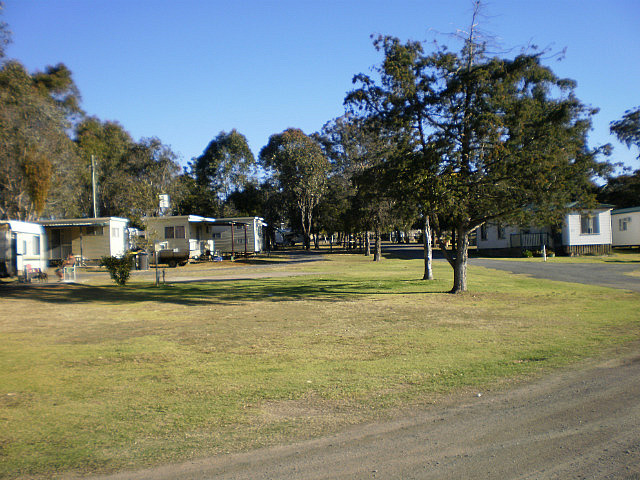
We arrived at the Van Park early afternoon and settled in to ensuite site 43 at $32.40 per night. This was our third visit to the Park and it is just as enjoyable as ever. After setting up the Van we went for a walk in the extensive grounds of the Park and discovered three Koalas sleeping in three different trees.
Gayndah is located on the Burnett River. It is 366 kilometres north of Brisbane, and 145 kilometres west of of Maryborough. In 2006 it had a population of 1,745. Agriculture and grazing have been the main industries in the area. The town was considered for the capital of Queensland, but lost to Brisbane because the river was not deep enough, making it impossible for large cargo ships to unload near the town. Gayndah is the oldest official town in Queensland. The name Gayndah is of Aboriginal origin and comes either from Gu-in-dah (or Gi-un-dah), meaning 'thunder', or from Ngainta, meaning 'place of scrub'.
Ban Ban Springs is a small community, located at the junction of the Burnett and Isis highways. On the southern side of the road junction are the springs from which the community gets its name, being rare springs from which waters flow into the nearby Barambah Creek. The name, "Ban Ban Springs", was originally used by H. Herbert when, in 1846, he first leased the pastoral run encompassing the springs. It is reported H. Herbert borrowed the words "Ban Ban" (meaning grass) from the local Wakka Wakka and/or Kabi Kabi languages.
Goomeri is in the South Burnett region of Queensland. The town is located on the intersection of the Burnett, Bunya and Wide Bay Highways, 235 kilometres from Brisbane . In 2006 Goomeri had a population of 488.
European settlement began in 1846 with the establishment of Booubyjan Homestead and Boonara Station. With delightful parks and many of the buildings built in the 1920s, Goomeri is a quiet and pleasant place that boasts an agreeably relaxed old world charm. The town is also known as "Clocktown" due to the landmark town clock built in 1939.
The Goomeri Pumpkin Festival, held on the last Sunday in May each year, attracts up to 14,000 visitors. The highlight of the Pumpkin Festival is the "Great Australian Pumpkin Roll" down Policeman's Hill.
Nanango is in the South Burnett region and is the fourth oldest town in Queensland. At the 2006 census, it had a population of 3,083. It is situated 210 kilometres north-west of Brisbane, and sits at the junction of the D'Aguilar and Burnett Highways. The area around Nanango was first settled by Europeans in 1847.
Beef, dairy and timber (in particular the valuable red cedar) were the primary early industries in the area. The discovery of gold at the Seven Mile Diggings near Nanango in 1867 precipitated a gold rush, and consequently a local population boom, however the gold deposits were found to be meagre. At one time the population included 700 miners, many of whom were Chinese . A second population boom occurred when the Brisbane Valley railway line was extended to Yarraman in 1911.
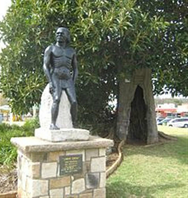
Crows Nest is a town in the Darling Downs region of Queensland. It is located on the New England Highway 158 kilometres from Brisbane and 43 kilometres from the nearby city of Toowoomba. In 2006 the town had a population of 1443. It is claimed by some that the town was named after an Aboriginal Jimmy Crow, who gave directions to early European settlers. He lived in a hollow tree known as green. However, it is also claimed that the name derives from the indigenous name for the area Tookoogandanna, meaning "the home of crows". A statue of Crow stands in the centre of the town.
Kilometres Travelled........305
Our journey to Crows Nest took us via the Burnett Highway through the towns of Gayndah, Ban Ban Springs, Goomeri, Nanango and Yarraman.
We arrived at the Van Park early afternoon and settled in to ensuite site 43 at $32.40 per night. This was our third visit to the Park and it is just as enjoyable as ever. After setting up the Van we went for a walk in the extensive grounds of the Park and discovered three Koalas sleeping in three different trees.
Gayndah is located on the Burnett River. It is 366 kilometres north of Brisbane, and 145 kilometres west of of Maryborough. In 2006 it had a population of 1,745. Agriculture and grazing have been the main industries in the area. The town was considered for the capital of Queensland, but lost to Brisbane because the river was not deep enough, making it impossible for large cargo ships to unload near the town. Gayndah is the oldest official town in Queensland. The name Gayndah is of Aboriginal origin and comes either from Gu-in-dah (or Gi-un-dah), meaning 'thunder', or from Ngainta, meaning 'place of scrub'.
Ban Ban Springs is a small community, located at the junction of the Burnett and Isis highways. On the southern side of the road junction are the springs from which the community gets its name, being rare springs from which waters flow into the nearby Barambah Creek. The name, "Ban Ban Springs", was originally used by H. Herbert when, in 1846, he first leased the pastoral run encompassing the springs. It is reported H. Herbert borrowed the words "Ban Ban" (meaning grass) from the local Wakka Wakka and/or Kabi Kabi languages.
Goomeri is in the South Burnett region of Queensland. The town is located on the intersection of the Burnett, Bunya and Wide Bay Highways, 235 kilometres from Brisbane . In 2006 Goomeri had a population of 488.
European settlement began in 1846 with the establishment of Booubyjan Homestead and Boonara Station. With delightful parks and many of the buildings built in the 1920s, Goomeri is a quiet and pleasant place that boasts an agreeably relaxed old world charm. The town is also known as "Clocktown" due to the landmark town clock built in 1939.
The Goomeri Pumpkin Festival, held on the last Sunday in May each year, attracts up to 14,000 visitors. The highlight of the Pumpkin Festival is the "Great Australian Pumpkin Roll" down Policeman's Hill.
Nanango is in the South Burnett region and is the fourth oldest town in Queensland. At the 2006 census, it had a population of 3,083. It is situated 210 kilometres north-west of Brisbane, and sits at the junction of the D'Aguilar and Burnett Highways. The area around Nanango was first settled by Europeans in 1847.
Beef, dairy and timber (in particular the valuable red cedar) were the primary early industries in the area. The discovery of gold at the Seven Mile Diggings near Nanango in 1867 precipitated a gold rush, and consequently a local population boom, however the gold deposits were found to be meagre. At one time the population included 700 miners, many of whom were Chinese . A second population boom occurred when the Brisbane Valley railway line was extended to Yarraman in 1911.
Crows Nest is a town in the Darling Downs region of Queensland. It is located on the New England Highway 158 kilometres from Brisbane and 43 kilometres from the nearby city of Toowoomba. In 2006 the town had a population of 1443. It is claimed by some that the town was named after an Aboriginal Jimmy Crow, who gave directions to early European settlers. He lived in a hollow tree known as green. However, it is also claimed that the name derives from the indigenous name for the area Tookoogandanna, meaning "the home of crows". A statue of Crow stands in the centre of the town.
- comments