

Profile
Blog
Photos
Videos


Huaraz
Ah, the Cordillera Blanca - 20 peaks over 6000m with Huaraz nestled beneath at a measly 3050m.
As we pulled into the Cruz del Sur bus station at dawn, Huaraz was wearing its rainy season attire, cloaked in a blanket of low cloud which lifted only once during our week-long stay to reveal the sparkling jewels of the Cordillera. The daddy of them all is Huascaran, the highest tropical mountain in the world at 6768m and the highest outside the Himalayas. Other famous names in the line-up include Pisco and Alpamayo.
With the mountains in hibernation, however, the main views of interest in the town were the brightly saddled alpacas munching hay in the town square waiting for customers, the pigs heads available for sale on corner carts alongside fruit and sweets, chickens being butchered on the roof opposite our bedroom window and the plates of raw fish and meat sitting unrefrigerated next to the till in the shop up the road.
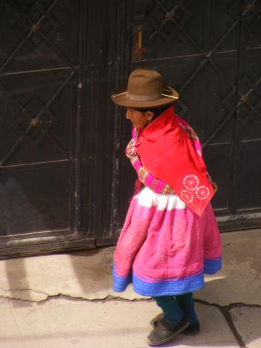
Huaraz itself is a little shabby around the edges, although regular earthquakes tend to do that to a place. Quite a few buildings seem to be held up by rickety wooden scaffolding, tied together with chicken wire. Life is pretty hard here, especially up in the hills where women spend their days bent double tilling the fields with hand ploughs or washing laundry by hand in the streams outside their doors, their grinding work and brightly coloured skirts and shawls contrasting sharply with the goretex clad hoards, rich in leisure time.
There are trekking possibilities galore here - including the Huayhuash circuit, home to Siula Grande, made famous by Joe Simpson and his severed rope. Sadly though we were stricken by stomach bugs and altitude sickness, which limited our activities. We made do with a wander up to Wilcahuain, a pre-Inca Wari tomb, nestled in the heavily farmed hills above the town, over a 1000 years old. The walk started at El Pinar, a gated community of houses in notably better nick than anything else we´d seen in the area. These are the homes of the staff of the Canadian-owned gold mines, who have arrived from outside the region.
Towards the end of the week we felt well enough to make the ascent up to the outrageously blue, prosaically named, Laguna 69 (4400m). A technically easy trek, it was made difficult by the altitude. Staggering a little with dizziness as we left Theo, our driver, at the roadside for his afternoon nap, we proceeded slowly along the valley floor, stopping for water and to catch our breath every 500m and we hadn´t even started the steep section. Big Pink Blouses! The walk helped with our acclimatisation though and we were able to enjoy a morning´s mountain biking before leaving for Lima.
On the way back from Laguna 69, amongst all the tumbledown houses with corrugated iron roofs, one unmarked building stood out as a concrete fort, complete with turrets and searchlights. What could it be? What could require such protection? Is it the local bank, a courthouse, or the gold-mines´ depository? No - it´s more important - it´s the beer factory!
On a more sombre note, Theo also told us about the landslide which destroyed the village of Yungay, killing 17,000 people in 1970. The only survivors had sheltered in the cemetery at the time, high above the town. It´s a strange old world...
- comments