

Profile
Blog
Photos
Videos

- Blog
-
Location Date North America 1463094000 South America 
1462748400 - Bahamas
-
Location Date Green Turtle Cay 1462748400 Kemps Point 1461970800 Nassau 1461020400 Moss Town
1460415600 Rock Sound 1459638000 Old Bight Settlement 1459292400 Victoria Village 1459036800 Governor's Harbour 1458086400 Old Bight 1457136000 Lower Deadman’S Cay 1455494400 George Town 1455235200 Black Point 1454544000 Bullocks Harbour 1454544000 Deep Creek 1454198400 Bailey Town 1453075200 Alice Town 1452470400 Man Of War Cay 1396998000 Seymour’S 1395014400 Rokers Point Settlement 1392336000 Baraterre 1391126400 -
Location Date Tue, 12 April 2016 1460466280 Thu, 07 April 2016 1460033934 Tue, 09 February 2016 1455021735 Wed, 03 February 2016
1454525304


January 31, 2016
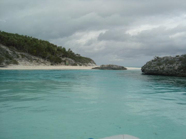
We got up and had breakfast, then dropped the dinghy to go ashore at Shroud Cay in Exuma Park. There is a creek that runs through the island to the other side that Karen wanted to explore. We motored north along the island shore for a couple of miles until we found the creek opening. There was a speed limit sign at the opening of the creek requiring no more than three miles per hour. This is to protect the fragile environment in the creek and to keep the noise down to not scare off the wildlife.
We headed up the creek which snaked through the island. We kept to the deepest part of the channel to make sure we did not kick up any sand and take it into the outboard motor. The creek seemed to go on forever as it turned back and forth across the island. We got to see a couple of sea turtles and many fish in the creek as we traveled through it. The mangroves were very small lining the creek barely reaching three feet tall. You could get a good view of the entire inside of the island due to the low flat growth of the interior.
We finally found the other side of the island and beached our dinghy on the northern shore. We walked the beach and the rocks above the beach exploring the island as best we could. We headed back the same serpentine route back down the creek to the original point we entered the creek on the western shore.
As we exited the creek the engine died. I immediately got the anchor out to prevent us being pushed away from the island by the prevailing wind. I worked on the engine a bit but could not determine the problem. There was fuel everywhere on the engine but I could not determine the source. We got out the oars and oarlocks determined to row ourselves back to the boat.
I rowed us closer to the lee of the shore to protect us from the winds and rowed along the shore for at least an hour. We were making good progress until we got to our anchorage and lost our protection from the wind. We popped out of behind a peninsula that was protecting us from the wind and the waves and tried to make progress towards our boat. The wind and waves were against us. The progress was very slow. It felt like we were making no progress at all.
We made it to the first mooring ball and tied off so I could rest. We had made it over half way to our boat in the mooring field. After catching my wind we again made the last push to our boat. Again we made very slow progress. By the time we arrived at our boat I was completely winded. We secured our dingy and went below to have lunch.
After lunch and resting we went back to work on the dinghy. We pulled off the 10 horsepower Nissan motor and replaced it with the 15 horsepower Yamaha. I did not realize how tired I was. I fell down three times while moving the Yamaha engine before getting it onto the back of the dinghy. The sea state did not help much with all the bouncing around we were doing while trying to switch out the motors.
We got the motor secured on the dinghy and then pulled it up on the davits for the night. We like to keep the dinghy up and out of the water at night. Keeping it out of the water helps prevent barnacle build up and also helps prevent someone from stealing your dinghy. Theft is a problem is some parts of the Bahamas.
February 1, 2016
We sent a text to Roland to see about the repair of our refrigerator before we move further south and farther away from Nassau. We are out of range for cell service, so to get messages out we have to send the phone up to the top of the mast where it will pick up a signal. We then bring the phone down and read our e-mail and messages. If we need to respond to what we just received, we type our response and send our cell phone back up the mast to send out the response.
Another daily routine is getting the weather. Every morning we pull out the Short Wave Radio and listen to Chris Parker's weather report from Florida. He reports the weather for the cruisers on the east coast/Bahamas and Caribbean. He is not real prompt at starting his broadcasts for the Bahamas until about 6: 45 or 7:00 and it runs until about 7:45. Having the current weather report is critical to deciding what you are doing that day: are you moving on to the next island or are you trying to find a hole to hide in to wait out the bad weather. This year has been horrible. The good days are well outnumbered by the bad by about 1 to 7.
The weather is OK for a move as long as we have some protection from the wind where we end up. We slipped our mooring at Shroud Cay at about 8:00 and head south to Hawksbill Cay. Instead of heading out to the main channel we skirt along the island shore and try to keep in deep enough water that we don't run aground.
We arrive at Hawksbill and tie up to the southern mooring field. When we went past the northern mooring field we did not see any mooring balls there as we passed. When we tied up we saw that we had the whole island to ourselves. Nice.
We dropped the dinghy and took it to the south shore of the island. The south side of the island is a large shallow lagoon with four mooring balls for dinghies to be tied to while the owners snorkel the crystal clear waters of the lagoon.
As we entered the lagoon we saw many fish. The fish appeared to be young barracuda. We drove by the mooring balls and took our dinghy to the beach for exploring. We walked the beaches until we tired out and then took our dinghy back to the boat. We did make one detour before going back to the boat. We climbed to the highest point on the island to understand the layout of the island and take some pictures.
After lunch I decided to take a stab at fixing the Nissan outboard motor. I got a bucket to sit on and pulled the cover off of the engine. I took the carburetor off the engine and put the parts into the cover for the engine so I did not lose anything. The fuel hose was twisted badly and was leaking but I was not sure if that was the problem. I took apart the carburetor and it looked pristine. I put the carburetor back on the engine, cut off the kink in the fuel line and reattached it. I then pulled the spark plugs and cleaned them. I put everything back together and gave it a pull. It started right away. Yea!
The weather report from Chris Parker stated that we would have squalls in the afternoon with winds in the 30+ knot range. Sure enough, the weather came in as predicted and we hunkered down for the rest of the night. We thought we were well protected from the east winds but the seas rolled around the southern point and hit us abeam. These seas had us rolling back and forth for most of the night.
A couple of hours before the storm two boats came in to the mooring field for what we thought was to wait out the storm. We watched the Canadian boat leave about a half an hour before the storm and head directly into the storm. What kind of idiot would drive dead into a storm? About an hour later they are back trying to catch a mooring ball in 30 knot winds and four foot seas. They try to catch the mooring ball right next to us but cannot get it onto the deck because of the source of the wind. They catch their breath and then try for another mooring ball further down and catch that one for the night. Hopefully they learned from that mistake. They sure took a beating getting in here and catching that mooring ball.
February 2, 2016
After our morning routine of breakfast and listening to the weather we dropped the dinghy and drove up to the north side of the island. We pulled the dinghy ashore and went looking for the Loyalist Ruins. A family of Loyalists settled on Hawksbill Island after being run out of the United States for supporting the crown. They arrived in 1785 and lived on the island until 1830.
We walked from the beach and followed the trail over the coral to the ruins. We found the old foundations of four buildings and a well. We also found a huge pile of conch shells between two of the buildings. The conch must have been a food source for these settlers.
After exploring and taking pictures of the ruins we headed back on the trail to a fork in the trail. We took the fork away from our dinghy and headed across the island to the eastern side. We found another beach there and explored it from end to end before returning back down the trail to our dinghy.
We went back to the boat to rest and have lunch. We then took our dinghy up a creek in the middle of the west side the island hoping to get thru to the east side. We made it about half way and ran out of water. I had to get out in my bare feet into the muck and turn the dinghy around and drag it until we had enough water again to run the engine. Each step I took sunk about a foot into the muck as I dragged the dinghy forward. We saw fish and sea turtles in the creek going up and back. And the creek here was also lined with small mangroves.
We headed back to the beach in front of our boat and hung out for a while wading into the water as far as we felt comfortable. The current water temperature was about 77 degrees Fahrenheit which was also the high temperature for the day. The water was bit too cool for us to enjoy swimming at the beach. I went up to the highest point on the island hoping for cell service but was unable to get a signal there as well.
We went back to the boat and snugged up everything for the journey to Warderick Wells tomorrow. The winds promise to be blowing up to 23 knots tomorrow so we need to be sure everything is secure before we make our trip tomorrow.
February 3, 2016
Winds are out of the southeast at 17 to 25 knots. We head out early hoping to get to Warderick Wells before the winds build up during the day. The seas are running four to six feet. We are hoping that we can set the sails to help to push us along.
The seas are knocking us around quite a bit and the winds continue to build as we head down the channel. There is not much chance of setting sail since as we head down the channel the winds are right on our nose. The seas and the winds get so bad that our forward progress is slowed to about three knots. The seas are continually coming over the bow. What are we doing out here in this weather? This is not very smart.
I tack away from the wind and the direction we want to go and our speeds increase and the intervals between the waves increase enough to lessen the pounding on the boat. We tack back and forth across our course until we can run down the channel to Warderick Wells.
We head down the channel and take the seas abeam. We rock and roll for about a half an hour until we get into the protection of the islands about Warderick Wells. I took us four hours to cover 14 miles. It was a slow slog indeed and not a very comfortable ride.
We were first on the list for a mooring due to being park supporters. They put us on mooring ball 22 which is on the far side of the horseshoe that forms the mooring field for Warderick Wells. At low tide we are surrounded on three sides by beaches. Nice. Warderick Wells is a good spot for waiting out a storm. It has a couple of openings but provides good all-around protection.
We tie up to the mooring ball and drop the dinghy so we can go ashore and pay for our mooring ball. We motor ashore and leave our dinghy at the dinghy dock. We then climb the stairs up the rock to the top where the ranger station is. Karen checks us in as I check out the Cruisers Library.
The Cruiser's Library is a book exchange where cruisers leave the books they have read and pick out books to read in the future. This keeps the weight down in the boats so you don't have to carry six months of reading material. These libraries are maintained for free where cruisers frequent.
We go back to the boat and chill for the rest of the day. We need to recover from the beating we took getting over here today.
- comments
Irene & John Great Blogs, guys. Bring back so many memories. But the two of you have done so much more than we did in two trips! We remember the two Great Danes that met us at W. Wells!