

Profile
Blog
Photos
Videos

- Blog
-
Location Date North America 1463094000 South America 
1462748400 - Bahamas
-
Location Date Green Turtle Cay 1462748400 Kemps Point 1461970800 Nassau 1461020400 Moss Town 1460415600 Rock Sound 1459638000 Old Bight Settlement 1459292400 Victoria Village 1459036800 Governor's Harbour 1458086400 Old Bight 1457136000 Lower Deadman’S Cay 1455494400 George Town 1455235200 Black Point 1454544000 Bullocks Harbour
1454544000 Deep Creek 1454198400 Bailey Town 1453075200 Alice Town 1452470400 Man Of War Cay 1396998000 Seymour’S 1395014400 Rokers Point Settlement 1392336000 Baraterre 1391126400 -
Location Date Thu, 04 February 2016 1454613241 Sat, 23 January 2016
1453507200
January 18, 2016
We were up at 5:30 to help Aquarelle off at 6:00. We waited around until 6:30 and they were still not up. We were trying to make a decision on whether to leave or not. The seas looked pretty brutal. We hear from Bright Eyes who was already out there and they told us the conditions were not that bad once you got away from Bimini.
It was now 7:00 and enough light to see what was going on. Low tide was at 8:30 so if we were going to leave it would have to be now. We pushed off and headed out. Mañana took the lead out the entrance and once he cleared the cut he started to get really knocked around. He reported no less than seven feet of water as he was going out so we followed them out.
Once we cleared the cut we really started to get knocked around. The wind was out of the north blowing 20 to 26 knots and the seas were about eight feet there at the entrance. We could barely get up more than four knots going out due to the seas and the wind. It was a long slow slog out to the deeper water.
Once we were in deeper water and away from Bimini the winds diminished a bit and the seas were a bit less lumpy. We turned and headed south for Triangle Rocks. There were five of us out there: Bright Ayes, Aquarelle, Mañana, Anne's Odyssey and Sea Vu Play. When a weather window opens, many of the boats start to move, often in the same direction.
We turned southwest at the Triangle Rocks and entered the Great Bahama Banks. We continued to follow Mañana along the banks because we were worried about shallow water. It was now low tide and we had chosen a course over drifting sands. We had a good chance of finding shallow water. We had the sails up and were heeled quite a bit hoping to keep our draft as shallow as possible.
We snaked through the shallow water thinking that Mañana was leading us through in a serpentine manner to avoid the shallows. The reported later they were just not paying attention to the course and were constantly drifting off and on course. Anyhow we managed to stay off the bottom but did see some very shallow water where the charts showed drifting sands. Note to self: if it says drifting sands, avoid it.
Once we saw deeper water we shut off the engines and sailed across the banks. The winds were out of the north at 11 to 17 knots and we were headed west. We were making great time doing better than seven knots but we were taking a lot of spray over the bow. Salt was collecting all over the boat and us. We were constantly cleaning our glasses so we could see. We pulled away from the pack and were pointing well. We started to take a more northerly route to avoid the shallow areas of the Mackie Flats. We were now close hauled.
Aquarelle was falling off but still maintaining good boat speed. Mañana was falling behind and Anne's Odyssey was trying to keep up with us. I believe everyone else had their engines on while we were the only ones with our engines off. The winds would settle down from time to time and we would slow down to about five knots. This gave the boats behind us a chance at catching up. I don't believe we were ever more than a couple of miles apart during the crossing. Bright Ayes was always out in front of us but we could always see their sails leading us the way across. We didn't catch up with them until we were in the anchorage at Great Harbor.
In the afternoon the winds began to abate a bit so we started our engine and ran it at low RPMs to keep our speed up.
It was a long day. As the sun was setting, I was beginning to wonder what the hell we were doing out here. I was really not enjoying the crossing and worrying about going into an unknown harbor at night. Going into an unknown harbor at night is never a good idea. All of the other boats we were with draw under five feet and we were drawing five feet nine inches fully loaded. I felt really exposed as we enter the channel showing depths of six feet at mean low tide. It was a nerve wracking trip down the Great Harbor channel.
After a few cross words between the Navigator/Admiral and the captain we chose a course away from the channel. There was some concern that we might hit one of the posts marking the channel. We later found that all but one of the posts in the channel were gone. Still here we are running full bore down an unknown channel showing a little over six feet in depth.
We made it to the anchorage without incident and dropped the hook in about seven feet of water. All that worrying we did was for naught. Bright Ayes was already there anchored with another boat named Maverick II.
We set the anchor easily. The others followed in and were all set just a few minutes later. It was now about 20:00 and time to relax. We set the anchor drift alarm and went to bed.
January 19, 2016
We called into the marina at Great Harbor and got out slip assignment. We made breakfast and ate. We then pulled anchor and headed down the channel.
Great Harbor Marina has great protection. You cannot see the entrance to the cut until the last seconds. We kept following the channel looking for an opening in the rocks but did not see it until we were fully on it. The entrance into the bay is a narrow cut through the coral. The cut has good depths running through it at about ten feet of water.
We ran straight in and missed our turn in the channel and ended up in a private lagoon. We turned around and found our next turn that took us toward the marina. We took another hard left at the end of the bay and entered the marina.
The protection in this marina is great. There are hills protecting the marina on both sides. The water is so flat you feel like you are standing on a stable platform. After six weeks of being knocked about in our boat, it is a great relief to be in such a protected hole.
We signed in at the marina and checked out the Wi-Fi. It was intermittent at best at our boat but pretty good up by the office. It was time to stretch our legs.
We took a walk with Mañana out to the shelling beach on the western side of the island. We walked by an old abandoned Golf Course Clubhouse. Local lore is that the Rat Pack used to hang our here in the 1970s. In the 1980s the economy went south and everyone abandoned the development. The island began to be used as a base for drug runners. Now the development is in ruins. There is a local that still does mow nine holes of the golf course for the locals to use. It is sad to see so many failed developments in these islands.
There was good shelling at the beach. Karen picked up a bunch of sea biscuits and urchins along the beach. We went over to check out the beach club for another possible trip. The sand here is much finer than at most of the beaches in the Bahamas. The beach is also much cleaner than others that we have visited.
There are homes built all along the beach with large lots. The vegetation is sparse growing on coral and sand. We actually found one home with an irrigation system trying to grow grass on all this rubble. They had little patches of grass here and there. Not sure if the grass will ever really take there.
There used to be huge mahogany forests on these islands back in the 1700s. Later these forests were clear cut for the lumber and without the trees the topsoil washed away. Now there are many non-native species taking root: coconut palms, Australian Pines and various other invasive species. It would have been nice to see what the islands looked like before the devastation by man.
January 20, 2016
We walked the marina and visited with several boats in the marina. We came up with a plan to go around the island and up one of the creeks in our dinghies to get to the shelling beach. We would then have our lunch there and return later in the afternoon. We had a bunch of people on board until we found out that the creek was dry (low tide) when we wanted to head up it. It was only full for a few hours during high tide. Another plan shot to hell.
OK. Time for plan B. We decided to go over to the Beach Club for Lunch. Illusions (Dave and Polly Brown) took the lead, with Bright Ayes, Anne's Odyssey, Mañana, and Sea Vu Play in tow. Dave showed us a shortcut through the old golf course. It was a nice walk through the overgrown roads and away from the island road traffic. We had a nice lunch at the Beach Club and enjoyed the beautiful scenery all around us as we ate.
We returned to our boat later and then took a dinghy ride into town. The town was a typical Bahamian town. The homes there are in various states of disrepair each having several broken down vehicles stored along the road or in their yards. There are a couple of grocery stores and a couple of Liquor stores. We managed to score some ice cream for $1.50 per scoop. The rum raisin ice cream was great.
January 21, 2016
We got up early and laid claim to four of the marina's bicycles for our day's excursion. We had a tough time getting enough air into the bicycle's tires with the hand pump until one of the cruisers came up with an electric pump to save the day. Thanks Manatee.
We rode by the abandoned golf course clubhouse and took a left at the T in the road. We headed north along the beach road. After a couple of miles we stopped at a beach access sign and walked out to the beach. There was not much to see but beach so we rested a while and then went back to the bikes.
We rode down the road past some pretty spectacular homes until we found a beach access sign for the caves. We parked the bikes and walked through the low brush until we found the caves. We climbed one of the large rocks to get a better vantage point for the cave. We then danced across the rocks to get to the entrance of the cave. The tide was up so there was not easy access to the cave.
The ladies decided not to enter the cave because they did not want to navigate the rocks. We searched the cave and found nothing. We then headed back to the bicycles and continued our trek north. The roads were surprisingly hilly. The boys would peddle up the hill and wait for the ladies as they walked their bikes up the hill.
The road began to be overgrown and no longer maintained. We wheeled through the growth until we found a trail that would take us to the beach. This path was unmarked and overgrown.
The path opened to the northern part of the island: Great Harbor. It was all iron shore where we came out at but the water colors there were fantastic. The boys hopped around the rocks and the ladies waded in the waters doing their own investigations. The Stirrup Cays were out in front of us. Each Cay had a Cruise Ship parked in front of it. These islands belong to the Cruise Lines and have been developed as a destination for their cruise passengers.
We went back to our bicycles and continued on the road which looped back on itself. We continued down the road and then took one of the side roads into town. We bought a few snacks to hold us over until lunch and then visited a few shops.
We headed back to the marina and returned our bicycles. We ate lunch and chilled for the rest of the day. We did walk down that evening to the fishing dock and bought four lobster tails for dinner. They were great! Eight minutes in the steamer and they were ready.
January 22, 2016
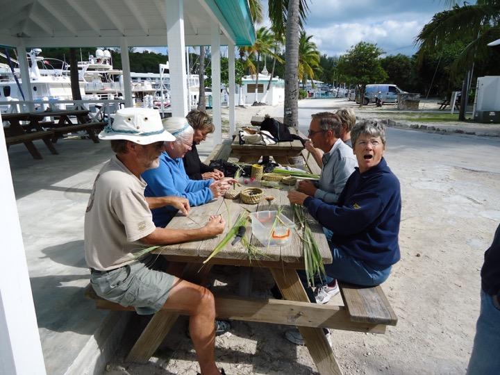
Today was a rainy day. We tried to make the most of it. I scrubbed the deck in the rain. We went over to Mañana to compare electronics and exchange movies. I retaught myself to weave baskets. We bought some grouper for dinner. We had another superb dinner thanks to the local fisherman.
- comments