

Profile
Blog
Photos
Videos
GoneExploring

- Blog
-
Location Date Europe 
1496012400 North America 1374274800 -
Location Date Reykjavik 1439766000 Skogar
1439593200 Hornafjorour 1439506800 Hallormsstadur 1439420400 Egilsstadir 1439334000 Husavik 1439247600 Varmahlid 1439074800 Hveragerdi 1438988400

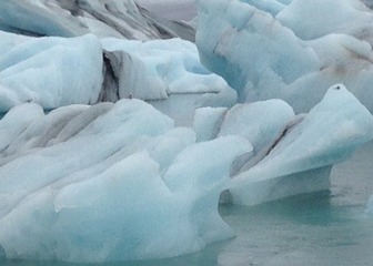
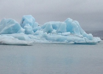


This morning we retraced our steps back to the glacier lake. It looks entirely different as the glaciers are more spread out across the lake. The weather is still and calm and there are fewer people around. We spend some time taking even more photos of icebergs, Arctic tern and seals before returning to the coach. The ocean is also calm and not as dramatic as it had been yesterday.
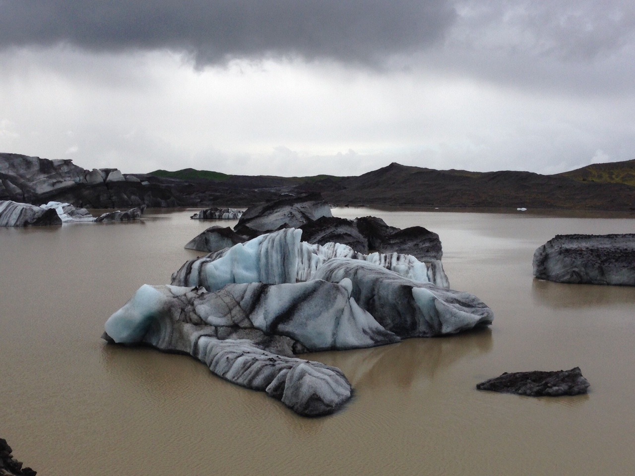
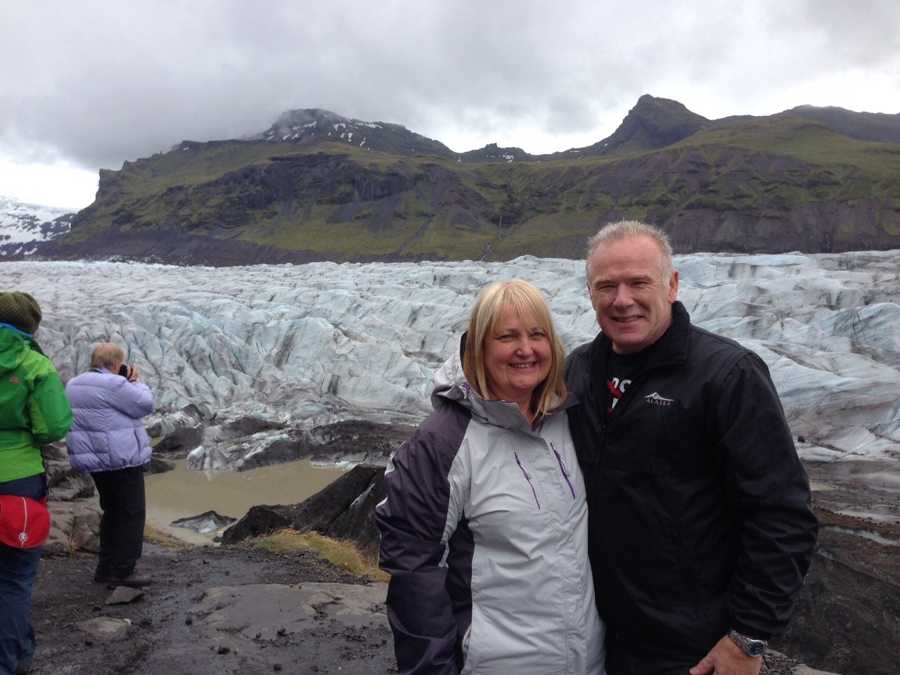
We are driving around the south side of Vatnajokull, the biggest glacier in Iceland. Although the low clouds are obscuring most of it, we can still see the tongues or outlets. Next we head to Skaftafell National Park take a short rocky hike to get up close and personal with one. The water is brown and some of the ice is black from the volcanic sand, along with the heavy clouds the whole scene quite appears menacing and surreal. I'm afraid I'm not very good with edges so was a bit of a scaredy cat, clinging tightly to Steve when it came to scrambling over the wet rocks, along narrow ledges to get closer to the glacier.
Continuing west, and with heavy rain setting in, we drive up a steep hill and park the bus to tackle the steep climb to Svartifoss waterfall. By the time we get back to the bus, the water has run down the front of my coat and soaked my trousers. Siggi immediately takes charge and insists I have a warm blanket over my legs.
We continue our journey and stop for photos at two more waterfalls, one of which is the beautiful double waterfall, Systrafoss. We later cross a bridge at the confluence of two rivers, one freshwater, the other glacial. Where the two meet, the muddy water from the glacier floats on top of the clear, fresh water showing a definite boundary before the two mix together.
We continue our journey, following the coast through the Lakagigar lava fields. The Laki eruption of 1783 lasted eight months. An estimated 20–25% of the population died in the famine and fluoride poisoning after the fissure eruptions ensued. Around 80% of sheep, 50% of cattle and 50% of horses died from the 8 million tons of hydrogen fluoride that were released.
The parish priest and dean of Vestur-Skaftafellssýsla Jón Steingrímsson (1728–1791), grew famous because of the eldmessa ("fire sermon") that he delivered on 20 July 1783. The people of the small settlement of Kirkjubæjarklaustur prayed as the lava threatened the town. The lava flow stopped while the townsfolk were still in church.
Kris showed us a book he had bought called, "Fires of the Earth" , which was a daily account of the effects of the eruption written by Jón Steingrímsson which read:
"This past week, and the two prior to it, more poison fell from the sky than words can describe: ash, volcanic hairs, rain full of sulfur and saltpeter, all of it mixed with sand. The snouts, nostrils, and feet of livestock grazing or walking on the grass turned bright yellow and raw. All water went tepid and light blue in color and gravel slides turned gray. All the earth's plants burned, withered and turned gray, one after another, as the fire increased and neared the settlements."
Bright green moss, called dýjamosi, up to 60 cms deep covers the lava Which Kristberg tells us is protected and people are not allowed to walk on it.
Siggi tells us that he spent a couple of years as a cowboy in Kirkjubæjarklaustur.
We cross vast black sandy plains produced by massive outbursts of water expelled by volcanic activity under the icecaps. Near the small town of Vik are three tall stacks of basalt, lying just offshore at the foot of the mountain Reynisfjall. The geological explanation is that Reynisfjall was eroded by the forces of nature to form these stacks. But the legend attached to them is much more colourful and more fun.
According to this story two trolls tried to drag a three-masted ship to land here. But trolls cannot go out in daylight, and these two made the mistake of staying out too long. When the first rays of the sun struck them and the ship they were turned instantly to stone. Whatever their origin, the stacks are certainly very striking. The tallest stands 66 metres above sea level and with the waves crashing against them and throwing up spray they are indeed an impressive sight.
Dyrhólaey is Iceland’s southernmost point, and one of its most spectacular. Since 1978 it has been a protected nature reserve and in the spring and summer is a nesting site for thousands of sea-birds.
This promontory is linked to the mainland by a causeway over which the road travels. Its name, Dyrhólaey, means “door-hole” and refers to a great rock arch in the cliffs here.
The cliffs here stand some 120 metres high and, with no landmass between here and Antarctica, the Atlantic unleashes its full force against them. At the foot of the cliffs are the dramatic black lava beaches, and off-shore a number of rock pillars and other formations, including in the distance the Reynisdrangar or Troll Rocks.
We descend from the cliff and park up again closer to the beach. There are emphatic warnings posted here about the dangers of the exceptionally strong currents, only yesterday, a family of three were swept into the sea. Fortunately, they were rescued but the entrance to the tiny beach where this happened was taped off.
Overnight at Hotel Skogar. There is an issue with the accommodation provided for Kris and Siggi. Siggi describes it as a shed that you wouldn't keep a pig in and refuses to stay in it. There is a great deal of concern and they decide to go to Reykjavic and return in the morning, a round trip of about 5 hours (?). It's a shame because this is our final dinner together and it spoiled it a bit.
- comments