

Profile
Blog
Photos
Videos

- Blog
- South America
-
-
Location Date San Pedro De Atacama 
1398294000 Stgo 1395792000 Pucón 1395360000 Valdivia 1395100800 Puerto Varas 1394496000 Torres Del Paine 1394236800

We are up early to catch the bus back into Chile to San Pedro De Atacama (our final stop in Chile) and this one takes us back through the Andes, but further north where at it's peak we reach an altitude of around 4500 metres (as benchmarks Everest is 8800m and Ben Nevis is 1344m). The scenery is fantastic and we pass through mountains of brightly coloured rock of reds, oranges and greens. We've got our faces stuck to the window for the most part and it makes the journey go quickly again
After about nine hours we stop in a dusty old town that doesn't look much and stay seated only to hear a few minutes later that this is our stop. An Australian sitting in front of us even gets off to ask 'what the heck is here!' The hostel owner had agreed to pick us up, but the bus is about an hour late (due to the usual disorganised border crossing) so we hang about for 20 minutes before deciding to make our own way there. The air is thin, the sun is hot and the packs are weighing a ton, but we have no choice as there are no taxi's or local buses to take us. After walking for about 20 minutes we are wondering what we are doing here as there really is nothing to pique our interest. Heading towards our tired bodies like a mirage is a car with 'Suzanne Gibson' stuck on a piece of paper in the window. We breathe a sigh of releif and bundle our tired, hot bodies into the car and then drive literally 10 metres up the road to the hostel. It would have been easier to walk that last bit. Inside there is a huge courtyard with hammocks in the trees and three scruffy dogs that come to greet us as we enter. None can really see out of their eyes with their long dirty fringes but they are very content at sniffing everything. We have a large ensuite room which is fine, however, the rest of the place, including the kitchen, is not so good and looks like it really needs a good clean. The hostel owner, Mario (from Ecaudor) is friendly and is able to give some recommendations for local tours and we head into town hoping that our first impressions will be quashed.
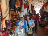
Once we get there we see that we missed the town on our way in and are pleased to see that there are lots of bars, restaurants and tour shops located mainly on one dusty strip. The place has character but lots of touts vying for our attention to buy their tours. We've done our homework and gone to one that has been recommended and its here that we book a couple of trips. We book Valle De La Luna for the following day and Lagos De Altiplano for the day after.
We are collected from our hostel and taken by minibus into the Valle De Luna (Valley of the Moon). This area is famous for its resemblance to the surface of the moon, owing to its different rock formations of peaks and craters that have been carved out by wind and rain erosion. The first stop is at Death Valley and it lives up to its reputation of looking like a moonscape. A prototype mars rover was used by scientists there due to it's dry and unforbidding terrain. It hasn't received a single drop of rain there for hundreds of years. While the guide is pointing out the volcano's in the distance and describing how the landscape has been shaped our interest turns to a sandboarder walking towards a huge dune of about 150 metres. Unfortunately he dosen't actually sand board down in the time we are there. We move on to another area with great scenic photo opportunities and then back on the bus for the Salt Mines where you can see the strips of salt crystals in the rock that have been caused by the effects of millenia of high pressure and the absence of any humidity. We are given a headlamp (although Steve's is broken and more of a hand lamp) to go deeper inside. It is only a short walk through, but we need to contort our bodies to duck under hanging rock and get through small gaps on our hands and knees. At the end we then scale an almost vertical rock to get out. We were glad that nature has left a few handles to enable us to haul ourselves up. Despite feeling like we are on an episode of Gladiator, there is beauty in the quartz and the shapes of the eroded rocks. After a stop at a rock formation called the Three Maria's that supposedly look like three women, but really only two and a half. (South Americans are 'highly imaginative' in looking for signs of the Virgin Mother, whether in rocks, profiles of mountains, cloud formations or vegetables, etc. Del Boy could have paid off Argentina's national debt in that leaky roof scam if the church had been in Buenos Aires rather than Peckham ). We climb for about 20 minutes up to a viewpoint on top of a dune to watch the changing colour of the surrounding mountains as the sun sets. It is truly magnificent and the photos won't do any justice to the colours we see as the sun gradually gets lower and then finally disappears. Another amazing sight to add to the list.
We start the Salar y Lagunas Altiplanicas (High Plain Salt Flats and Lakes) by visiting the National Reserve of the Flamingoes set within the salt plain. The salt plain is caused by the rain water that runs under the mountains in subterranean rivers collecting minerals and salts on its way. At the plains the water evapourates depositing the salt crystals which leave a whitish/grey crust of salt spanning 3000 sq km.
The heavily salted lake draws flamingoes to the area as there are brown shrimp for them to feed on. They pad around in the water to bring the shrimp closer to the surface, and then scoop them up through their hook shaped beak while standing on one leg. Why do they stand on one leg? Researchers believe it is because water invariably draws away more body heat, so to make sure they can feed all day they stand on one leg. Not sure how much difference a spindly leg can make but I'm sure they wouldn't do it just for the fun of it.
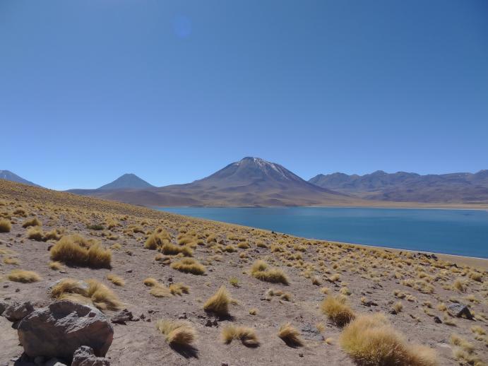
We then move up higher to 4,200 metres to the Lagoons Miscanti and Miniques. Thousands of years ago these waters ran as streams down the mountainside, but following a volcanic eruption of the Miniques Volcano the path of the streams were blocked up and the lakes formed. The lakes, the mountains, flora and fauna are a breathtaking sight (the air is so thin too that it really does take our breath away). We see three Vicunas ( a wild breed from the llama family) drinking from the lake. As another small herd come closer for a drink the three stand their territory and then chase the others away. Despite creeping closer, the thristy travelling pack fail each time as they are chased again and again. Why don't they share just like humans would (not!) or go to a different part of the huge lake!
We have lunch in a local restaurant in a small village named Socaire. Here we have a type of minestrone soup containing alphabetti spaghetti, bread with a spicy piquant sauce which is then followed by slow cooked pork and rice. They do a roaring trade with tourists and everything is served at record speed. We walk down to the tiny village church that has a thatched roof and seperate bell tower. The surrounding hillsides are heavily farmed in terraces and the local people mainly use their own produce, with only a small amount leaving the village to trade in the larger towns.
Our guide points out the route of the ancient Inca road, spanning high along the distant mountain tops. It ran from southern Colombia deep into Chile along the Andes, with an intermittent parallel route along the Pacific coast and various branches and side roads linking the two or extending into Argentina and Bolivia. The roads running east to west were in line with the route of the sun, which the Inca's worshiped as a God. The Inca's built such a good network of roads with excellent connections, this was known as the first 'Incanet'.
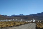
As we are in a high desert there is no cloud in the sky to hide the billions of stars above us so we go on a recommened stargazing tour. We go on the bus about 15 minutes out of the town where there is no light pollution. Everything is so clear and the Canadian astonomer uses his laser torch to point out Mars, Jupiter, Saturn, the Southern Cross, Orions belt, the closest star, milky way and the stars that outline the various signs of the zodiac. A good imagination is needed to make out some of shapes, but then we suppose there was no TV in those days and it probably passed an evening taking the cocoa and hallucinating about lions, virgins and scorpions high in the sky.
We are also told how the stars changing positions helped early humans in knowing when winter was coming and so to harvest their crops etc
He says there are no jokes in astronomy but proceeds to roll out one corny line after another. The loudest laugh comes from Steve.
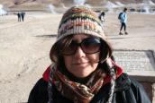
One thing worth noting about San Pedro De Atacama is that as it is at an altitude of 2500m and in the desert, the daytime temperature can be as high as 28 degrees and after the sun goes down it can get to an extremity numbing minus 15. We are bundled up with so many layers of clothes and are also given a blanket but still feel the biting cold.
There are 10 telescopes set up pointing to planets and star constellations. All are interesting to see, but the most interesting one is Saturn and it's rings. After over an hour of standing outside, we are invited inside for some hot chocolate and a question and answer session. One of Steve's facts about there being more stars in the sky than there are grains of sand on the earth remains unconfirmed as the guide is unable to answer this. (Technical note from Steve: the universe is thought to be 13.8 billion years old and we can only see light from stars that exist (or have existed) in this zone. There could be, and probably are, many other galaxies well beyond, but their light has not reached us yet. Given time, 'Steve's fact' will inevitably be proven QED).
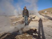
We are up at 4am for the one and a half hour bus ride up in to the mountains to see the El Tatio Geysers at sunrise. We are left to sleep on the way there and wake when we get to the entrance of the geothermal fields. The geysers are thought to be one of the highest elevation in the world at 4400 metres. There are approximately 80 of them spread over approx a 4sq km area and we can see the tall plumes of steam rising high in the breaking dawn. They are hissing and spitting and can jump into life without notice shooting out boiling water and steam . There are stories of tourists who have got too close and fallen through the thin crust around them and being boiled alive, so we stick to the path amazed at how many stupid people go close and stand right over them for the ultimate photo shot. As the sun rises the surrounding mountains look a deep red and gradually become paler as the sun rises higher, in reverse to what we have seen a few days previous at the Valle De Luna..
There are thermal baths there that a few people go into but as it's minus nine outside we wimp out.
They make us breakfast by boiling a bag of eggs and cartons of milk in the geysers.
On the way back we stop at a tiny village named Machuca that has a population of fifty people. The houses are made of adobe (mud), cactus wood and straw. Previously living as llama shepherds, the few residents now run the village purely on tourism. A man sporting the leathered look is barbequeing llama meat kebabs, whose meat is so tender and lean and really delicious. We follow this with a goats cheese empanada that is also really good.
Suzanne has had a pressured headache, tingly toes and fingers, insomnia and fatigue, which we think may be a mild altitude sickness. To combat it we buy some cocoa tea and cocoa leaves from the market to put the locals remedy to the test. Not really sure if it really worked or acted as a placebo, but the heavy head begins to lift eventually after about five days. Luckily there is no nausea or sickness.
We try to book our onwards bus to Arica on the northern Chilean border which will take us into Peru, but find that they are all fully booked as it's May Day tomorrow. We book the next one out, which means one extra night at Mario's. We take the Archeological tour on our final day which is only a few kilometres out of town. This area is known as the archeological capital of Chile. We walk around the pre-Inca ruins of a village that doubled as a fortress. The area known as Pukara de Quitor is named due to the battle between the Spaniards and the Atacamians in1540 when Spaniards beheaded 300 soldiers and displayed the heads on the fortress wall. The town soon became to be known as 'The Village of the Heads'
We head further into the desert to a the Tulor Village that dates back to 800 BC - 500 AD. From a small recently constructed walkway we can view the remaining walls of the houses. A Jesuit Priest and keen Archeologist named Gustavo Le Paige is credited with discovering the ruins. Although covered with lots of sand you can see the houses are made from clay which was collected locally from the river. The rooves were thatched using the desert bushes, so they have long disappeared. It is thought that the strategic region of this area was productive to trade so the people living here would be kept busy making handicrafts. We go into a reconstructed house that only contains a central fire pit used for cooking and to heat the house. We are told that up to twenty people would live in one of these they would need to sleep top to toe so that they all fit in.
Our final stop is at a small farm where we try syrups made from some of the fruit trees on the farm. We drizzle it over popcorn and quinoa (maize cereal) and also some home-made fruit bread that tastes delicious.
Talking of food, there are some great restaurants in the town with huge roaring fires and a great pub that shows non stop sport, including a Crystal Palace game. It proved a bit of a pain to get to but we have really enjoyed our time here and happy to be in a small town surrounded by some truly spectacular natural wonders. However, time to move on...
- comments
Jo Foston Phew, glad you enjoyed it! :) Amazing pics. Outstanding xx
Elisa Thomson Sounds incredible, imagine if you'd have decided to give it a miss! Enjoying reading the blog and all the interesting facts along the way. Missing you and wish I was experiencing it too! Lots of love and stay safe xxxxxxx