

Profile
Blog
Photos
Videos

- Blog
- Europe
- UK
-
Location Date Highland 1342134000 Innerleithen 1341702000 Cumbria 1341615600 Liverpool 1341442800 Clun 1341356400 Southville 1341270000 Callington 1341097200 Truro 1341010800 Portsmouth London Penzance Devon Perth Ballater Inverness 
Helmsdale
Yesterday we left Perth and the black silhouette of Cairngorms National Park loomed before us as we made our way to Glenshee and the highest A road in the country. Little did we know that Glenshee was just the warm up.
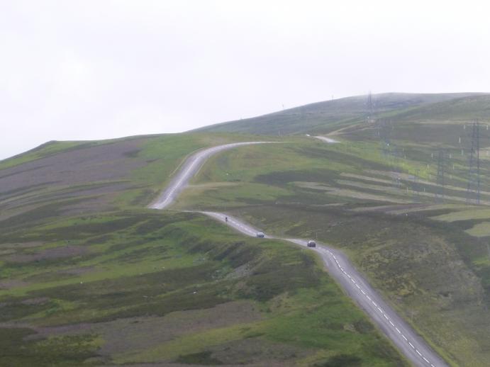
We left our hotel this morning with foreboding after all the staff's friendly questioning on where we were heading, came to the same conclusion: "You're not going over the Lecht, are you?! Aye, Glenshee is fine, but this is…" At this point, words failed them and hand movements suggested an upward, wiggling road. The Lecht was another Ski centre, almost as high has Glenshee. The first climb was fine. It kicked up a couple of times, and on one particularly steep kick we pulled over to admire the view from the top and could smell the burning engines of the cars as they too struggled up. We also met our End to End friends from Birmingham early on. They were struggling as one had hurt his calf and after offering pain killers and seeing we could do nothing to help, we went on.
For much of the day, we could see the road stretch out into the distance, and soon enough I saw a section that looked particularly steep. We turned the corner and there it was, the start of the Lecht and a dreaded triangular road sign: 20%. A lot of these hills are as much about mental power as muscle power, and I admit that after about 30m I got off and walked. But I only walked for about 10-20m and when the road levelled slightly, I manned up and got back on to cycle the rest. Ha! Beat you, horrible hill! There was a little viewing platform near the top of the steep section (which was probably about 2km long) which had a coach load of Swedish tourists cheering and taking pictures of the mad English girl cycling up the steep hill (Andy had already been through and met a similar reception). 'Darn it! I have to cycle the rest now!' Only 300m to go, they shouted. Sadly, I knew it was another 2 miles to the top, as I had just passed the sign. Still, it levelled off after that and was only about 12%... still hard, but a lot more manageable. The ski centre was closed, so we had to go all the way down before being rewarded with coffee and scones.
Another little climb and we started heading out of Cairngorms National Park. To our left we could see the Highlands and as the rain was holding off at this point, we got to see some of the views Scotland is famed for.
Theoretically, at this point it was all downhill to the coast. Whilst not bad as an uphill, being fairly steady, it was the worst downhill ever! Still, it must have been down as moorlands gave way to pine forests, and pine forests gave way to fields. We crested our final hill: I can see the sea!! We crested another final hill, and we could see the sea and a boat. There was something so special and satisfying to look back and see Cairngorms loom behind us and know that through the rain, wind and steep hills, we conquered those mountains and were through!
We stopped in Nairn for some more food and a walk around the town centre and the harbour. This was where my father was born, so it was quite special to be there. It has some pretty buildings, but we were sadly too late to visit the museum.
The rain started again in time for our last little effort to Inverness. Andy got excited on route as we passed the location of the Scottish Open (it took me a while to realise this was golf related). By now we were so close to the sea, we could smell it!
Can't tell you much about Inverness as we're not really in the town centre, but we went to a nice CMRA pub for dinner (which was on Scottish BBC news later, relating to that golf tournament thing). I had ice cream for pudding as I saw the sea first.
- comments
Ken Nearly there, only a few more climbs to go. Enjoy the culmination of the journey and savour the achievement. I hope the weather is kind for you during the last miles.
Penny Awesome! I scream, you scream, we all scream for ice-cream!