

Carl's latest entry
Hiawassee, Georgia (USA)
Having issues with my app updating the blog here is what I tried to post about my hike to Neil's gap:
Today awoke in the company of my new friends and we ate a double serving of French toast, scrambled eggs, and grits. When we hit the trail I went ahead just trying to warm up in the early morning air. I soon realized that my rest at the …


Aunt Cathy Hi Carl The adventure sounds wonderful so far! Hope you continue to experience "trail magic." I'm looking forward to reading future posts. Take good care of yourself.
re: Dahlonega, Georgia (USA)Al & Bonnie Glad you made it to a nice hostel and a bed, shower, internet, and more food. What in the world do you have to eat to get 6,000 calories in a day? Who decides on your trail names? Take care of your feet! Enjoy North Carolina. It is beautiful!
re: Dahlonega, Georgia (USA)Garden Gnome Carl forged ahead doing 15 and 18 mile days for the last 2 days. The terrain was up and down. He is at Deep Gap shelter tonight. There are a few others he met there. Last night the mice took his sock. The backpack was not safe up on the wall. They ate through a bag inside his pack. No damage to the pack. Tonight, he will be using the ropes to hang his pack. There is a mouse nest up near the ceiling. Tomorrow, he has 3 + 11 miles day. The last part is off the AT. He will go into Hiawassee and wait for Brandon. His feet are sore today. Basically, he is about 12 miles south of the North Carolina border. For those in Australia, Carl is walking almost 3, 500 miles/5630 kms. This would be the distance between Cairns and Albury (Vic) via capital cities, or Perth to Melbourne.
re: Dahlonega, Georgia (USA)Frances Hello Carl, What a journey! We are thinking of you, and pray for your safety and we know you will always remember all of the wonderful things that you see and learn on this trip. Looking forward to hearing more from you, Frances
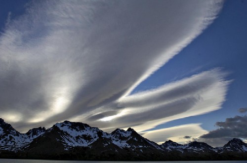
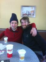
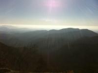
re: Dahlonega, Georgia (USA)Garden Gnome I spoke to Carl about 12 hours ago. He was about to make a post to the blog and upload photos, but since he hasn't, I will add a comment. The next point he expects to be able to make wireless connection will be 4 - 5 days away (about 28th). At the time I spoke to him, they were in a lodge at Neels Gap. The wireless connection was not strong enough to upload pictures. He had stepped outside to speak and I could hear the wind in the background. He said it was quite cold outside at night. Inside, they had the company of many really fascinating people. One such person is Triton. His background is Political Science. So perfect for Carl! Despite the gruelling first part of the journey to reach higher elevation, both are in great spirits. Carl mailed his tent back to FL. That gives him up to 4.5 more pounds for food. There are shelters available every night in GA. He has a tarpaulin made of better material than the tent, should they find themselves without a shelter. Fresh water is abundant, and so are the mice at night in the very basic shelters. It apparently is a bit of a bother for some, but by the time Carl sleeps, he doesn't care about little feet. (Carl's feet are good.) Brandon left his water bottle at Rainbow, but came across a good one at a shelter, where there are exchange boxes for travellers. Earlier on when the path was all vertical, Carl and Brandon had underestimated their caloric needs. They need about 6,000 cal/day. Other trekkers gave them food until they could get more. The previous night, the two stayed in a hostel that was beautiful and the people were very generous. The hostel owners picked them up from the trail, took them into town to get supplies and to buy a big feast of Chinese food, then drove them back to the hostel, which had a comfy bed. In the morning, the owners fed them extremely well, and the result: Carl was turbo charged. He went 8 hours with a 2 minute sit down. Reaching the mountain top where David had taken him 6 months earlier, he lay on the rock and soaked up the sun until the others caught up. That particular vista inspired Carl to hike the AT. Apparently, the beauty of the land is enchanting. The trip has been marked by a deep sense of camaraderie and amazing serendipitous events. Carl's voice was very elated.
re: Dahlonega, Georgia (USA)Carl's mum Steve and Teri...you must be the wonderful people who drove Carl and Brandon to the state forest. Thank you so much!!! You really went out of your way and it helped them enormously. Thank you to everyone who has given them a hand!
re: Dahlonega, Georgia (USA)Steve and Terri Glad to see you made it to the trail. We will enjoy following your blog. Stay healthy.
re: Dahlonega, Georgia (USA)Garden Gnome This website has pics and a nice map of the trail. On a different tab, it has addresses of mail points. Not sure if they would work for the guys: http://markjoat.blogspot.com/2010/12/hiawassee-to-neels-gap-to-hiker-hostel.html
re: Jacksonville, FloridaAT&T coverage http://www.wireless.att.com/coverageviewer/#?type=voice&lat=34.76228961591244&lon=-84.26814706715038&sci=9
re: Jacksonville, FloridaGarden Gnome Mike and Stella - Thanks so much!!! You are awesome! Copy and paste the coordinates in this format: 34 39' 50.896"N, 84 11' 3.135"W drop into Google and ....all you can see are trees! I am looking for the boys... I found a map of BMT: http://www.bmta.org/pdfs/BMT-OverviewMap.pdf and some info: http://www.bmta.org/ The Trail The Benton MacKaye Trail (BMT) is a footpath of nearly 300 miles (480 km) through the Appalachian mountains of the southeastern United States. It is designed for foot travel in the tradition of the Appalachian Trail (AT). Running from Springer Mountain in Georgia to Davenport Gap on the northern edge of the Great Smoky Mountains National Park (the Smokies), the BMT passes through some of the most remote backcountry in Georgia, Tennessee and North Carolina, including eight federally designated Wilderness and Wilderness Study Areas. For further information on the trail, visit the BMT Vital Info page. For Hikers There are numerous access points and trailheads along the BMT route creating many options for one-way and loop hikes, and several more in combination with local trails. Longer hikes are possible on the BMT by doing a partial or full thru-hike. And the longest walks are done by also using the three major intersecting trails, the Pinhoti, the AT, and the 900-plus mile Mountains-to-Sea Trail. Because the BMT intersects the AT at each terminus and in the middle, three large hikable loops are formed in a figure 8: a lower circle of 364 miles, an upper Smokies-only walk of 158 miles, and 'The BMT Loop' - a complete circuit hike of over 500 miles. The Georgia Loop, "toughest hike in Georgia", is a 55-mile triangle of the BMT, the AT and the Duncan Ridge Trail. In the Eastern Continental Trail; the 4400-plus mile route from Key West, Florida to Cape Gaspe, Quebec, Canada; the BMT connects the Pinhoti and Appalachian Trails. For more hiker information, check the Hiker Resources page.
re: Jacksonville, FloridaGarden Gnome Mike and Stella - Thanks so much!!! You are awesome! Google Earth does lat/long coordinates. I found a map of BMT: http://www.bmta.org/pdfs/BMT-OverviewMap.pdf and some info below from: http://www.bmta.org/ The Trail The Benton MacKaye Trail (BMT) is a footpath of nearly 300 miles (480 km) through the Appalachian mountains of the southeastern United States. It is designed for foot travel in the tradition of the Appalachian Trail (AT). Running from Springer Mountain in Georgia to Davenport Gap on the northern edge of the Great Smoky Mountains National Park (the Smokies), the BMT passes through some of the most remote backcountry in Georgia, Tennessee and North Carolina, including eight federally designated Wilderness and Wilderness Study Areas. For further information on the trail, visit the BMT Vital Info page. For Hikers There are numerous access points and trailheads along the BMT route creating many options for one-way and loop hikes, and several more in combination with local trails. Longer hikes are possible on the BMT by doing a partial or full thru-hike. And the longest walks are done by also using the three major intersecting trails, the Pinhoti, the AT, and the 900-plus mile Mountains-to-Sea Trail. Because the BMT intersects the AT at each terminus and in the middle, three large hikable loops are formed in a figure 8: a lower circle of 364 miles, an upper Smokies-only walk of 158 miles, and 'The BMT Loop' - a complete circuit hike of over 500 miles. The Georgia Loop, "toughest hike in Georgia", is a 55-mile triangle of the BMT, the AT and the Duncan Ridge Trail. In the Eastern Continental Trail; the 4400-plus mile route from Key West, Florida to Cape Gaspe, Quebec, Canada; the BMT connects the Pinhoti and Appalachian Trails. For more hiker information, check the Hiker Resources page.
re: Jacksonville, FloridaMike & Stella Met the boys on the AT/BMT near Three Forks (Noontootla Road Crossing-FR58) [34 degree 39' 50.896" N, 84 degree 11' 3.135" W] and they were doing fine.... excited about their second day on the trail and the adventure in front of them. Wish them the best.
re: Jacksonville, FloridaAl & Bonnie You two made it to Gainsville, Ga. on the bus. So are you crossing Lake Lanier toward The Amicalola Falls State Park, and then north to the AT?
re: Jacksonville, FloridaDad The joy of public transport in America. I remember a long August night in the KC train station around 1966 before they Thought AC was a necessity. Have fun.
re: Jacksonville, Florida