

Profile
Blog
Photos
Videos

- Blog
-
-
Location Date Johannesburg 1275001200 South Africa 
1274914800 Springbok 1256947200 Cape Town 1256860800 Bedfordview 1256338800


Fancy a little history and geography lesson …. read on, if not skip and move onto the next blog entry. (Source: www.worldmapmaker.com )
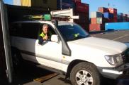
Once the travel bug bites, there is no known antidote, and we shall be happily infected until the end of our lives.So off we go to explore this beautiful continent of ours, and beyond.
AFRICA' GEOGRAPHY
Africa: Africa is the second-largest of the seven continents on Earth (Asia is the largest continent) Africa covers 11,700,000 square miles (30,300,000 square kilometres).
Countries: There are about 53 countries in Africa (some countries are disputed). The biggest country in Africa is Sudan, which covers 2,505,816 square kilometres. The countries with the largest populations in Africa are Nigeria (107,000,000 people), Egypt (64,800,000 people), and Ethiopia (58,700,000 people).
Highest and Lowest Points: The highest point in Africa is Mt. Kilimanjaro, in Tanzania (eastern Africa). Mt. Kilimanjaro is 5895 meters tall. Africa has no long mountain chains.
The lowest point in Africa is Lake Assal, in Djibouti (in eastern Africa near the Horn of Africa); it is 156 meters below sea level.
Lakes: Africa's largest lake is Lake Victoria; it covers 26,836 square miles (69,500 square kilometres). Other large lakes in Africa are Lake Tanganyika, Lake Malawi, and Lake Chad.
Rivers: The longest river in Africa is the Nile River; it is 4,241 miles (6825 kilometres) long. Other long rivers in Africa include the Congo River, the Niger River and the Zambezi River.
Deserts: Africa has many vast deserts, including the largest hot desert in the world, the Sahara. The Sahara Desert is located in northern Africa and covers 9,065,000 square kilometres. The Kalahari, in southern Africa, is another large desert.
SOUTH AFRICA - THE COUNTRY
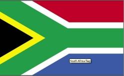
The Flag (adopted 27 April 1994) (source www.worldflags.com)
The flag consists of 2 horizontal stripes of equal width - red on the top and blue on the bottom.The red and blue stripes are separated by a green middle stripe which is bordered in white and splits into a horizontal Y.On the left side of the flag there is a black isosceles triangle which is outlined in yellow.
Meaning: the colours black, yellow and green represent the ANC party colours and the red, white and blue the former Boer republic flags.The Y shape represents the convergence of South Africa's diverse society and the desire for unity.The flag is made up of former flags and the past meanings of the colours were red for bloodshed, blue of open blue skies,green for the land, black for the black people, white for the European people and yellow for its natural resources such as gold.
History: Dutch traders landed at the southern tip of modern day South Africa in 1652 and established a stopover point on the spice route between the Netherlands and the East, founding the city of Cape Town. After the British seized the Cape of Good Hope area in 1806, many of the Dutch settlers (the Boers) trekked north to found their own republics. The discovery of diamonds (1867) and gold (1886) spurred wealth and immigration and intensified the subjugation of the native inhabitants. The Boers resisted British encroachments but were defeated in the Boer War (1899-1902); however, the British and the Afrikaners, as the Boers became known, ruled together under the Union of South Africa. In 1948, the National Party was voted into power and instituted a policy of apartheid - the separate development of the races. The first multi-racial elections in 1994 brought an end to apartheid and ushered in black majority rule under the African National Congress (ANC). ANC infighting, which has grown in recent years, came to a head in September 2008 after President Thabo MBEKI resigned. Kgalema MOTLANTHE, the party's General-Secretary, succeeded as interim president In April 2009 Jacob Zuma become President.
Area: total: 1,219,912 sq km land includes Prince Edward Islands (Marion Island and Prince Edward Island). Slightly less than twice the size of Texas.
Land boundaries: total: 4,862 km border countries: Botswana 1,840 km, Lesotho 909 km, Mozambique 491 km, Namibia 967 km, Swaziland 430 km, Zimbabwe 225 km
Climate: mostly semiarid; subtropical along east coast; sunny days, cool nights
Natural resources: gold, chromium, antimony, coal, iron ore, manganese, nickel, phosphates, tin, uranium, gem diamonds, platinum, copper, vanadium, salt, natural gas
Population: 49 million
Nationality: South African
Ethnic groups: black African 79%, white 9.6%, coloured 8.9%, Indian/Asian 2.5% (2001 census)
Religions: Zion Christian 11.1%, Pentecostal/Charismatic 8.2%, Catholic 7.1%, Methodist 6.8%, Dutch Reformed 6.7%, Anglican 3.8%, Muslim 1.5%, other Christian 36%, other 2.3%, unspecified 1.4%, none 15.1% (2001 census)
Languages: IsiZulu 23.8%, IsiXhosa 17.6%, Afrikaans 13.3%, Sepedi 9.4%, English 8.2%, Setswana 8.2%, Sesotho 7.9%, Xitsonga 4.4%, other 7.2% (2001 census)
Government type: republic
Capital: name: Pretoria (administrative capital) Cape Town (legislative capital); Bloemfontein (judicial capital)
Independence: 31 May 1910 (Union of South Africa formed from four British colonies: Cape Colony, Natal, Transvaal, and Orange Free State); 31 May 1961 (republic declared) 27 April 1994 (majority rule)
National holiday: Freedom Day, 27 April (1994)
Currency: Rand (ZAR)
Exchange rates: rand (ZAR) per US dollar - 8.015 (2009 est)
- comments