

Profile
Blog
Photos
Videos

- Blog
-
Location Date Oceania 1288742400 North America 
1284505200 -
Location Date California
1284505200 Hawaii 1284246000 Nevada 1282777200 Arizona 1282604400 Utah 1282345200 British Columbia 1281481200 Alberta 1281135600 Washington 1280444400 Montana 1280185200 Illinois 1279839600 New York 1279580400 Ontario 1279494000 Massachusetts 1279407600 Washington D.c. 1279148400 -
Location Date Venice Beach Hostel 1284505200 Los Angeles Part One 1283036400 Groveland Hotel, Yosemite National Park
1282258800 The Blackwell's In Los Gatos 1281999600


Days 43 - 45, Yosemite National Park
We woke up to Chocolate Chip Pancakes, Penny's last treat for us, and what a treat it was! I'm holding her fully responsible for the extra pounds I've put on during our stay! Anyway, far too soon it was time to head off on our big road trip and after some photos, directed by the next up and coming sensation (Matthew Blackwell) we were on our way.
The drive was uneventful I'm pleased to report and nothing truly spectacular, just full of very straight roads taking us towards California's border. During the last few miles the landscape changed and the road started to climb. It became very narrow and windy and once again there were very few crash barriers along the edge.
In no time at all we arrived in Groveland after a couple of hours drive. This was 20 miles from the Park's boundary and the closest lodgings we could find. We checked in to find we were actually staying three miles further down the road in an Annex so onwards we went. On arrival we were greeted by one of the groundkeepers who regretfully informed us that our room wasn't yet ready. He was a very helpful gentleman and very friendly as well. Once he learned we were English he proudly announced his name was Thornton and he was very pleased there was a chocolate brand named after him! He advised us to visit a section of the Park which over 90% of visitors don't bother to see so off we went.
We stopped by the park entrance first to get our entrance ticket and some advice from the rangers on which walks to do whilst we were here. They suggested we do the Mist Trail, which is a path that climbed the valley past two spectacular waterfalls hence it's name. When the falls are full hikers feel the full force of the mist from quite a distance. This sounded good to us so we took a map and continued to Hetchy Hetch.
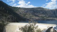
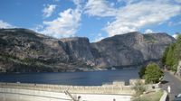
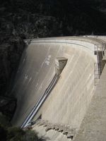
Hetchy Hetch is a reservoir with quite a lot of history behind it. It is the water supply for San Francisco and it angered a lot of people when the valley was flooded and the dam was created. It's quite spectacular though and was definitely a great place to visit. The reason most people don't go there is because it is at the end of a dead end road (about an hours drive) that you can only get to if you exit the Western entrance. There's only one hotel and a camp site on that road so many people don't have any reason to go down there and it is very out of the way. It's a shame because it is truly amazing. You can see the dam and then the water from quite a way away and the last tiny stretch of road into the car park goes right beside the reservoir. We walked across the dam and took in the views on both sides of the wall. Once again the lake had an incredible backdrop of mountains to it and was fed by three waterfalls, two of which would be visible from the dam except the nearest one runs dry in the summer and was noticeably absent. You could see where the water would flow however. The other waterfall was a small trickle and it was easy to see that this National Park was completely different to Glacier. The glaciers feed the waterfalls and rivers all year long and everything is very green there. In Yosemite there are trees and there is greenery but it's more sparse and it is more barren with the temperatures being much higher and all the water coming from snowmelt.
When we got to the other side of the Dam we found a tunnel had been blasted through the mountainside allowing ramblers to access the far side of the reservoir. You can pick up a trail here and walk to the waterfalls mentioned earlier. We walked a little way before deciding to save our energy for the next day and back we headed to the car.
On our return trip back to our room I drove, yes me! I didn't think it was fair to ask Dan to drive over 2000 miles on his own over the next couple of weeks so I decided to have a practice where it was very quiet and the speed limit was very low. The journey back was nice and steady and I stopped in several lay bys to let Dan get out and take photos. We saw Mark again when we got back who was pleasantly surprised that we had taken his advice. He kept saying "I can't believe you really went" and then asked us if we'd walked through the tunnel as if to check we weren't pretending we'd been! As his first suggestion had been such a good one I asked him where we should go for dinner and he recommended the Mexican restaurant in Groveland so once we had dropped off our bags off we went for one of the nicest meals I have had on this whole trip! I didn't have the usual fajitas, I was brave and went with the Enchiladas, and they were very very yummy!
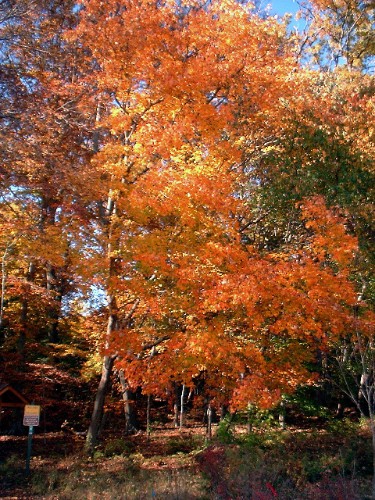
We got up early doors the next morning to make the most of our only full day in the Park and headed back to Groveland for our breakfast. Once we had eaten our fill of an average meal (toast cereal and bagels) we headed back down the road and set off for Yosemite Village, stopping off along the way to take in some truly amazing views. Within half an hour I was completely bowled over and did not want to leave. I drove inside the park to allow Dan to take the 700 photos he wanted. We stopped off at so many places I can't mention them all! Our first noticeable stop was at Bridalveil Falls (yep, its' the third time we've been here) and we walked just under half a mile to the base of the falls. They were very beautiful and once again quite graceful with a faint trickle of water rather than a full gush. The book told us it's a different story in Winter though and I think we were quite lucky to see any water at all!
The next stop was at the Swinging Bridge (no, it didn't swing so I wasn't sure about the name??) The bridge crossed the river to where the river bed opened up and became sandy. It also had a natural pool in the river and there were a few people taking advantage of it too. It was a popular spot for families and picnics and it was lovely to dip our toes in the surprisingly cold water before we continued on.
Our next stop was the car park at the start of our hike. We ate our lunch before we set off so we didn't have to put it in a bear bin, and changed into our boots and off we went. The first thing we saw was a cage, yes a cage! It was a bear trap and it was located in the heart of the village. We guessed that if the bears make it into the village this is the way to get them out again, instead of letting them get themselves out. We instantly realised we were parked in the wrong car park and this added a mile onto the route, DOH!
We came to the river and the official start of the walk and on we went with huge crowds of people. As usual there were plenty of health and safety signs at the base before the path starts to rise quite steeply to the first destination, a bridge that crossed the river and your first glance at Vernal Falls. It's 0.8 miles to this bridge along a paved path that can accommodate wheelchairs and buggies and it is the last place you have restrooms and drinking water fountains. It was a popular spot for paddling, and in come cases wading and it became obvious that a huge proportion of tourists turn back here. As it was an extremely hot day Dan took advantage of the water and did some dunking whereas I splashed the refreshing water onto my face and used the facilities before continuing on.
The path dramatically changed at this point and the mileage sign now warned it was a foot trail only. It became quite narrow, natural and steeper, very much like the Grouse Grind path in that it became stone steps. It was quite hard going, made increasingly difficult when it came to overtake slower walkers, they didn't make it easy! As the path was so narrow if anyone was coming the other way one of you would have to give way and as there is an unspoken walking rule that downhill hikers have right of way I stepped aside frequently to no acknowledgement or word of thanks or anything! This really started to get on my nerves so I made a point of being extremely nice whenever anyone let me pass. I got some confused and baffled looks!
We arrived at the top of Vernal falls quite quickly and were rewarded with some magnificent views of the valley below. Emerald Lake fuels the falls and there are numerous signs advising that swimming is strictly forbidden as there are strong undercurrents. This meant there were at least half a dozen people in the water, including children. It was very difficult not to jump in as the water looked so inviting and we had worked up quite a sweat (did I tell you it was over 40 degrees centigrade today??) but we resisted (stubborn old lifeguard!). I drank quite alot of water at this point thinking this was where we were turning back and that we wouldn't need much before we could replenish from the fountain at the bridge. Dan informed me it was only another mile to the Nevada Waterfalls, which we couldn't quite see at this point. Ooops! And before you start screaming "Drink the stream water" at your PCs (or Macs) there were signs everywhere saying water needed to be treated before being consumed. Double doh! Oh well.
So onwards we went and by now it was much more quieter with only a few people on the path. Again, another fairly steep climb but not as narrow or dramatic as the previous one and we soon made it to our destination. Again, another pool in the river before the fall, again more no swimming signs, again people swimming, *sigh*. This walk was definitely one of our favourites so far and we had both well and truly fallen in love with Yosemite.
After more splashing water and drenching ourselves and some comical photo opportunities we set off back down, this time on the John Muir trail. The signs said it was a further distance but as there were no "foot trail only" signs I though it might be a smoother walk with horses possibly using them. I was right too and the journey down was very pleasant and it seemed like no time at all when the path split and we took the right hand fork back to the top of Vernal Falls where we rejoined our original path.
We got back down to the road and to our car in just over five hours and we covered eight miles. When you add the amount of time we spent hanging around while Dan took his 500 photos we actually spent about three, three and a half hours walking, which we didn't think was too bad for the elevation gained.
On our way back out of the Park we stopped by the river to wash away all the sweat and dirt we has accrued during the walk. The water was freezing but invigorating and Dan was so desperate to get in he got in in his boxers as he hadn't brought his swimmers!
We headed straight to Groveland for food, not wanting to be stung by expensive restaurants in Yosemite Village. As we like last night's meal so much we ate there again so we ate Mexican three nights in a row!!
Friday morning arrived and we packed up once again but alot more easily than normal. It's great having a car, you can just throw things into carrier bags and dump it all in the boot! Nice one!
We headed towards Glacier Point and spent a short while sat in yet some more National Park roadworks (nowhere else in America, just in the Parks!) We stopped several times in lay bys and started playing a new game, we saw a lovely photo of the Leggs on facebook taken in Yosemite so everytime we saw a little stone wall we kept saying "Ooohhhh, this is where they had their photo taken!" Convinced we had found the exact spot we would move on and it would start again. However, we do actually think we found the correct lay by just before the tunnel. We shall compare!
We got to Glacier Point and joined crowds in their hundreds marvel at the stunning Yosemite Valley below. We could see exactly where we had walked yesterday, and also discovered Dan had been calling the wrong piece of cliff face the Half Dome so he has a trillion photos of the incorrect landmark! That was quite funny. We hung around for about 45 minutes taking in the different views, enjoying the sunshine and taking lots of photographs before making a move back down the valley and onto Tioga Road and Rogers Pass, which took us across the Park to the East side where we would eventually exit. It was lovely driving through the tall trees that lined the road and provided precious shade from the harsh sun and it is incredible just what you can find in one country.
Our next stop was at Olmstead Point, where large rock boulders rested on huge slabs of granite. This place is named after a famous landscape architect, who designed Central Park in NYC. The granite stretches for miles, as far as you can say with the boulders dotted around and tall green trees in little clusters. If you look one way you look down across the valley and if you turn and walk a little in the opposite direction you come across a wonderful view of Tenaya Lake peering through the forest.
We drove on to this very lake where we had our daily swim. We found a little sandy bay area and it felt like we were the only ones swimming although you could just make out other people in the water in the distance. It's so magical swimming in clear waters with panoramic views all around you, it's like the film set of a movie. I didn't want to get out, surprise surprise!
We shortly came to our final stop *sniff sniff* just a few miles on, a very famous Meadow which stretch along the Tuolumne River for ten miles. Again, as I've already said it is amazing just what you can find in one place and it is hard to believe, standing in the 40 degree heat that winter lasts for eight months here.
We walked along the trail for a short while until we came to Soda Springs, natural springs in the ground. There was also a memorial lodge in honour of Parsons who campaigned to stop the Hetchy Hetch Dam from being built without success. The lodge is used as respite from the afternoon thunderstorms and often has exhibits as well.
All too soon it was 7pm and time to leave this incredible place and continue on our Road Trip and we were sad to go but it is somewhere we will visit again!
Love Elles xx
- comments