

Profile
Blog
Photos
Videos

- Blog
-
Location Date Oceania 
1336258800 North America - New Zealand
-
Location Date New Brighton 1336258800 Christchurch 1336172400 Dunedin 1336086000 Fiordland National Park 1335999600 Queenstown 1335913200 Fox Glacier 1335826800 Abel Tasman National Park 1335654000 Nelson 1335567600 Lower Hutt 1335481200 Tongariro National Park
1335394800 Taupo 1335308400 Waitomo Caves 1335222000 Waipoua Kauri Forest 1335049200 Manurewa 1334962800 Auckland 1334790000 Franz Josef Glacier Kaikoura Wellington

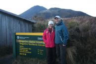


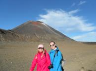
Up at 5 am to catch shuttle to Tongariro base camp. Started hike at 7 am. Sun just peeking over the mountains. 19.4 kms of unbelievable vistas! The first half of the hike was extremely challenging with an elevation gain of 765 meters in just a few km. The track winds up the Mangotepopo Valley to the Saddle between Tongaririo and Ngauruhoe (2 active volcanos). We then climbed to Red Crater (1886 m), the highest point of the hike. The trail dropped down to Emerald Lakes which are water-filled explosion craters.The color is due to dissolved minerals that have washed down from the surrounding thermal areas. We stopped here for lunch and checked out the volcanic steam coming out of fissures in the rocks-strong sulpher smell and too hot to hold your hand over, really amazing to think we are over an active volcano! After passing Blue Lakes, we hiked down the northern slope of Tongariro, then a zigzag descent to Keteahi Hut (1454m). From the hut the track continues down the mountain through tussock plains into the native forest and the end of the hike. Exhausting but totally worth it!! The weather was amazing- clear, blue skies with few clouds. Average walking time for the trail is 5-6 hours with no stops. We finished the crossing in 6 hours, 15 minutes stopping for lunch and 2 snack breaks. Steve wanted to make the first shuttle back and beat everyone else who had been on the bus with us-not surprising that he wanted to be first! LOL We can see why the crossing is one of the world's finest day hikes-definitely an experience you don't get every day! We had an early supper and were in bed by 7 pm.
- comments
Joyce Now that is a hike - it looks so barren and cold but beautiful